 |
|
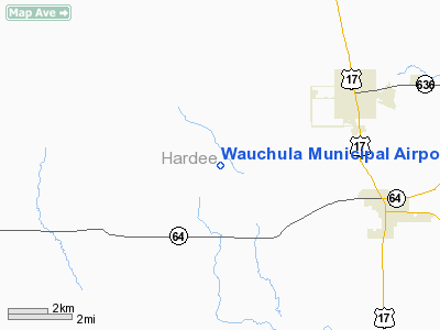
Wauchula Municipal Airport |
Coordinates: 27°30′53.66″N 081°52′49.665″W / 27.5149056°N 81.8804625°W / 27.5149056; -81.8804625
| Wauchula Municipal Airport |
| IATA: none – ICAO: KCHN – FAA LID: CHN |
| Summary |
| Airport type |
Public use |
| Owner |
City of Wauchula |
| Operator |
Jerry Conerly |
| Serves |
Wauchula, Florida |
| Location |
Hardee County, Florida |
| Elevation AMSL |
106 ft / 32 m |
| Runways |
| Direction |
Length |
Surface |
| ft |
m |
| 18/36 |
4,005 |
1,221 |
Asphalt |
| Statistics (2002) |
| Aircraft operations |
8,201 |
| Based aircraft |
44 |
| Source: Federal Aviation Administration |
Wauchula Municipal Airport (ICAO: KCHN, FAA LID: CHN) is a public-use airport located 5 miles (8.0 km) southwest of the central business district of the city of Wauchula in Hardee County, Florida, United States. The airport is publicly owned.
The above content comes from Wikipedia and is published under free licenses – click here to read more.
Location
& QuickFacts
|
FAA Information Effective: |
2007-01-18 |
|
Airport
Identifier: |
CHN |
|
Airport
Status: |
Operational |
|
Longitude/Latitude: |
081-52-49.6650W/27-30-53.6600N
-81.880462/27.514906 (Estimated) |
|
Elevation: |
106 ft / 32.31 m (Estimated) |
|
Land: |
160 acres |
|
From
nearest city: |
5 nautical miles SW of Wauchula, FL |
|
Location: |
Hardee County, FL |
|
Magnetic Variation: |
04W (2000) |
Owner
& Manager
|
Ownership: |
Publicly owned |
|
Owner: |
City Of Wauchula |
|
Address: |
Po Box 818
Wauchula, FL 33873 |
|
Phone
number: |
863-773-3535 |
|
Manager: |
Jerry Conerly
SUPT OF PUBLIC WORKS, CITY OF OF WAUCHULA. |
|
Address: |
726 E Green Street
Wauchula, FL 33873 |
|
Phone number: |
863-773-3535 |
Airport
Operations and Facilities
|
Airport Use: |
Open to public |
|
Wind
indicator: |
Yes |
|
Segmented
Circle: |
No |
|
Control
Tower: |
No |
|
Lighting
Schedule: |
DUSK-DAWN |
|
Beacon
Color: |
Clear-Green (lighted land airport) |
|
Landing
fee charge: |
No |
|
Sectional
chart: |
Miami |
|
Region: |
ASO - Southern |
|
Boundary
ARTCC: |
ZMA - Miami |
|
Tie-in
FSS: |
PIE - Saint Petersburg |
|
FSS
on Airport: |
No |
|
FSS
Toll Free: |
1-800-WX-BRIEF |
|
NOTAMs
Facility: |
PIE (NOTAM-d service avaliable) |
|
Federal Agreements: |
NGY |
Airport
Communications
Airport
Services
|
Fuel available: |
100LLMOGAS |
|
Airframe Repair: |
MINOR |
|
Power Plant Repair: |
MAJOR |
|
Bottled
Oxygen: |
NONE |
|
Bulk
Oxygen: |
NONE |
|
Runway Information
Runway 18/36
|
Dimension: |
4005 x 75 ft / 1220.7 x 22.9 m |
|
Surface: |
ASPH, Good Condition |
|
Edge
Lights: |
Medium |
|
|
Runway 18 |
Runway 36 |
|
Longitude: |
081-52-49.6900W |
081-52-49.6400W |
|
Latitude: |
27-31-13.4900N |
27-30-33.8300N |
|
Elevation: |
100.00
ft |
108.00
ft |
|
Alignment: |
127 |
127 |
|
Traffic
Pattern: |
Left |
Left |
|
Markings: |
Basic, Fair Condition |
Basic, Fair Condition |
|
Crossing
Height: |
21.00 ft |
32.00
ft |
|
Displaced
threshold: |
500.00
ft |
0.00 ft |
|
VASI: |
4-light PAPI on left side |
4-light PAPI on left side |
|
Visual
Glide Angle: |
3.00� |
3.00� |
|
Runway
End Identifier: |
No |
No |
|
Obstruction: |
43 ft trees, 1068.0 ft from runway, 20:1 slope
to clear |
8 ft tree, 336.0 ft from runway, 110 ft right
of centerline, 17:1 slope to clear
APCH SLOPE 25:1 FROM 18 FT TREES, 450 FT FROM EOR, 130 FT
R OF CNTRLN. |
|
Radio Navigation
Aids
|
ID |
Type |
Name |
Ch |
Freq |
Var |
Dist |
|
CHN |
NDB |
Wauchula |
|
261.00 |
04W |
0.3 nm |
|
PCM |
NDB |
Plant City |
|
346.00 |
02W |
32.8 nm |
|
TPF |
NDB |
Knight |
|
270.00 |
02W |
38.6 nm |
|
VNC |
NDB |
Venice |
|
206.00 |
02W |
40.1 nm |
|
AM |
NDB |
Picny |
|
388.00 |
02W |
41.1 nm |
|
RHZ |
NDB |
Zephyrhills |
|
253.00 |
03W |
45.3 nm |
|
MCF |
TACAN |
Macdill |
047X |
|
04W |
39.6 nm |
|
PGD |
VOR |
Punta Gorda |
|
110.20 |
03W |
36.4 nm |
|
LAL |
VORTAC |
Lakeland |
107X |
116.00 |
01E |
29.2 nm |
|
SRQ |
VORTAC |
Sarasota |
099X |
115.20 |
02W |
36.6 nm |
|
PIE |
VORTAC |
St Petersburg |
111X |
116.40 |
01E |
48.9 nm |
|
LBV |
VORTAC |
La Belle |
041X |
110.40 |
01E |
48.9 nm |
|
TPA |
VOT |
Tampa Intl |
|
111.00 |
|
44.3 nm |
Remarks
- BLDG
175 FT EAST AND PLINE 250 FT EAST OF RY 18/36 SOUTHERN 1/4 RY IN 7:1
TRANSITION SURFACE.
Based
Aircraft
|
Aircraft
based on field: |
44 |
|
Single
Engine Airplanes: |
40 |
|
Multi
Engine Airplanes: |
2 |
|
Helicopters: |
1 |
|
Ultralights: |
1 |
Operational Statistics
Time Period: 2001-07-18
- 2002-07-17
|
Aircraft
Operations: |
158/Week |
|
General
Aviation Local: |
41.0% |
|
General
Aviation Itinerant: |
59.0% |
Wauchula Municipal Airport
Address:
Hardee County, FL
Tel:
863-773-3535
Images
and information placed above are from
http://www.airport-data.com/airport/CHN/
We
thank them for the data!
| General
Info |
| Country |
United
States |
| State |
FLORIDA
|
| FAA ID |
CHN
|
| Latitude |
27-30-53.660N
|
| Longitude |
081-52-49.665W
|
| Elevation |
106 feet
|
| Near City |
WAUCHULA
|
We don't guarantee the information is fresh and accurate. The data may
be wrong or outdated.
For more up-to-date information please refer to other sources.
|
|


