 |
|
Coordinates: 29°59′22″N 084°23′43″W / 29.98944°N 84.39528°W / 29.98944; -84.39528
| Wakulla County Airport |
 |
| IATA: none – ICAO: none – FAA LID: 2J0 |
| Summary |
| Airport type |
Public use |
| Owner |
Wakulla County |
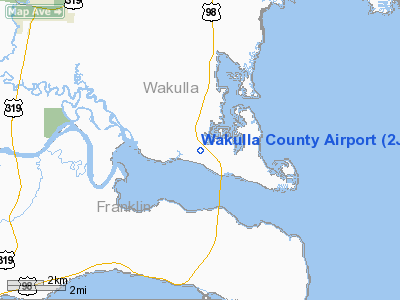
| Location |
Panacea, Florida |
| Elevation AMSL |
11 ft / 3 m |
| Runways |
| Direction |
Length |
Surface |
| ft |
m |
| 18/36 |
2,590 |
789 |
Turf |
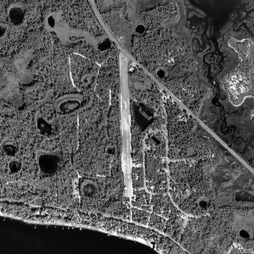
Wakulla County Airport (FAA LID: 2J0) is a public airport located 3 miles (5 km) south of the central business district of Panacea, in Wakulla County, Florida, United States. This general aviation airport is owned by Wakulla County and is open to the public, although pilots are required to call ahead to be allowed ground access.
Facilities
Wakulla County Airport covers an area of 15 acres (6 ha) and has one north-south grass runway:
- Runway 18/36: 2,590 x 70 ft (789 x 21 m), Surface: Turf
The above content comes from Wikipedia and is published under free licenses – click here to read more.
Location
& QuickFacts
|
FAA Information Effective: |
2007-01-18 |
|
Airport
Identifier: |
2J0 |
|
Airport
Status: |
Operational |
|
Longitude/Latitude: |
084-23-43.4100W/29-59-22.0400N
-84.395392/29.989456 (Estimated) |
|
Elevation: |
11
ft / 3.35 m (Surveyed) |
|
Land: |
15
acres |
|
From
nearest city: |
3 nautical miles S of Panacea, FL |
|
Location: |
Wakulla County, FL |
|
Magnetic Variation: |
01W (1985) |
Owner
& Manager
|
Ownership: |
Publicly owned |
|
Owner: |
Wakulla County |
|
Address: |
Po Box 1263
Crawfordville, FL 32326-1263 |
|
Phone number: |
850-926-0919 |
|
Manager: |
Roger Shilling |
|
Address: |
34 Monocappe Circle
Panacea, FL 32346 |
|
Phone number: |
850-984-0590 |
Airport
Operations and Facilities
|
Airport Use: |
Open to public |
|
Wind
indicator: |
Yes |
|
Segmented
Circle: |
No |
|
Control
Tower: |
No |
|
Lighting
Schedule: |
RDO-CTL
ACTVT LIRL RY 18/36 - CTAF. |
|
Landing
fee charge: |
No |
|
Sectional
chart: |
Jacksonville |
|
Region: |
ASO - Southern |
|
Boundary
ARTCC: |
ZJX - Jacksonville |
|
Tie-in
FSS: |
GNV - Gainesville |
|
FSS
on Airport: |
No |
|
FSS
Phone: |
850-377-3291 |
|
FSS
Toll Free: |
1-800-WX-BRIEF |
|
NOTAMs
Facility: |
GNV (NOTAM-d service avaliable) |
Airport
Communications
Airport
Services
|
Airframe Repair: |
NONE |
|
Power Plant Repair: |
NONE |
|
Bottled
Oxygen: |
NONE |
|
Bulk
Oxygen: |
NONE |
|
Runway Information
Runway 18/36
|
Dimension: |
2590 x 70 ft / 789.4 x 21.3 m |
|
Surface: |
TURF, Poor Condition |
|
Edge
Lights: |
Low |
|
|
Runway 18 |
Runway 36 |
|
Longitude: |
084-23-43.4100W |
084-23-43.4100W |
|
Latitude: |
29-59-34.8600N |
29-59-09.2200N |
|
Traffic
Pattern: |
Left |
Left |
|
Displaced
threshold: |
200.00
ft |
375.00
ft |
|
Obstruction: |
15 ft road, 120.0 ft from runway, 8:1 slope
to clear
RY 18 APCH RATIO 28:1 TO DSPLCD THLD DUE TO TREES ACROSS THE
ROAD. |
27 ft trees, 48.0 ft from runway
RY 36 APCH RATIO 20:1 TO DSPLCD THLD DUE TO 18 FT HANGAR AT
EOR WEST OF CNTRLN. |
|
Radio Navigation
Aids
|
ID |
Type |
Name |
Ch |
Freq |
Var |
Dist |
|
TL |
NDB |
Wakul |
|
379.00 |
01W |
20.3 nm |
|
AAF |
NDB |
Apalachicola |
|
349.00 |
02W |
36.7 nm |
|
FPY |
NDB |
Foley |
|
254.00 |
03W |
42.1 nm |
|
SZW |
VORTAC |
Seminole |
122X |
117.50 |
02E |
34.1 nm |
|
GEF |
VORTAC |
Greenville |
027X |
109.00 |
01E |
46.4 nm |
|
TLH |
VOT |
Tallahassee Muni |
|
111.00 |
|
24.8 nm |
Remarks
- +50'
TREES BOTH SIDES OF RY 100' FROM CNTRLN IN TRANSITIONAL SFC.
- AER
36 HAS 10-25' TREES AND 5' FENCE.
- VFR
ONLY.
Based
Aircraft
|
Aircraft
based on field: |
10 |
|
Single
Engine Airplanes: |
9 |
|
Ultralights: |
1 |
Operational Statistics
Time Period: 2001-03-12
- 2002-03-11
|
Aircraft
Operations: |
106/Week |
|
General
Aviation Local: |
71.2% |
|
General
Aviation Itinerant: |
28.8% |
Wakulla County Airport
Address:
Wakulla County, FL
Tel:
850-926-0919, 850-984-0590
Images
and information placed above are from
http://www.airport-data.com/airport/2J0/
We
thank them for the data!
| General
Info |
| Country |
United
States |
| State |
FLORIDA
|
| FAA ID |
2J0
|
| Latitude |
29-59-22.040N
|
| Longitude |
084-23-43.410W
|
| Elevation |
11 feet
|
| Near City |
PANACEA
|
We don't guarantee the information is fresh and accurate. The data may
be wrong or outdated.
For more up-to-date information please refer to other sources.
|
|


