|
|
Tampa Executive Airport
(formerly Vandenberg Airport) |
| IATA: none – ICAO: KVDF – FAA LID: VDF |
| Summary |
| Airport type |
Public |
| Owner |
Hillsborough County Aviation Authority |
| Serves |
Tampa, Florida |
| Elevation AMSL |
22 ft / 7 m |
| Coordinates |
28°00′50″N 082°20′43″W / 28.01389°N 82.34528°W / 28.01389; -82.34528 |
| Runways |
| Direction |
Length |
Surface |
| ft |
m |
| 5/23 |
5,000 |
1,524 |
Asphalt |
| 18/36 |
3,259 |
993 |
Asphalt |
| Source: Federal Aviation Administration |
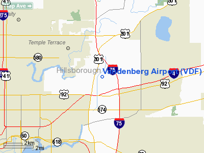
Tampa Executive Airport (ICAO: KVDF, FAA LID: VDF), formerly known as Vandenberg Airport, is located in unincorporated Hillsborough County, Florida, six nautical miles (11 km) east of the central business district of Tampa.
The airport was renamed in January 2009 in order to better identify the facility with the Tampa Bay area, and to lessen confusion with Vandenberg Air Force Base in California.
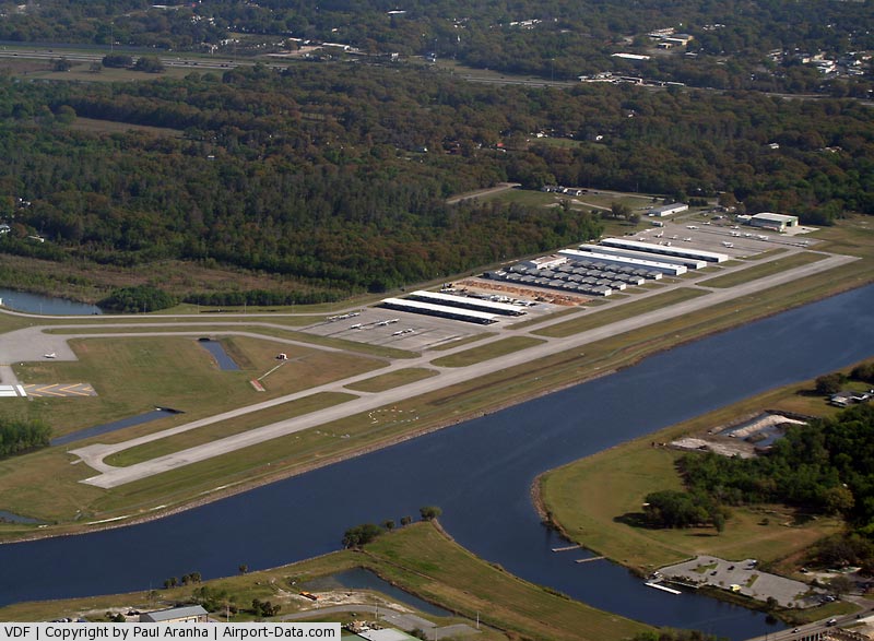
It is a general aviation airport servicing the downtown Tampa business traffic, as it is only 15 minutes from the heart of Tampa. Tampa Executive has two runways, one 3,264 feet and the other 5,000 feet. Tampa Executive is operated by Leading Edge Aviation Services. The airport is located near the intersection of I-4 and I-75. The airport is open 7:00 A.M. - 7:00 P.M. 7 days a week, and after-hours service is available upon request.
Although most U.S. airports use the same three-letter location identifier for the FAA and IATA, this airport is assigned VDF by the FAA but has no designation from the IATA.
Accidents
On July 17, 2008, a single-engine Beechcraft Bonanza crashed shortly after takeoff after clipping an antenna tower. One of the aircraft's wings was torn from the plane. As a result of the wing damage, the aircraft crash landed short of runway 23 in an open field area and burst into flames. All three passengers on board were killed. The pilot was a volunteer for Angel Flight which transports non-emergency medical patients to and from area medical centers for treatment. The passenger being transported had just finished treatment for cancer.
The above content comes from Wikipedia and is published under free licenses – click here to read more.
|
 |
(Click on the photo to enlarge) |
Location
& QuickFacts
|
FAA Information Effective: |
2007-01-18 |
|
Airport
Identifier: |
VDF |
|
Airport
Status: |
Operational |
|
Longitude/Latitude: |
082-20-43.0000W/28-00-50.3000N
-82.345278/28.013972 (Estimated) |
|
Elevation: |
22
ft / 6.71 m (Surveyed) |
|
Land: |
109 acres |
|
From
nearest city: |
6 nautical miles E of Tampa, FL |
|
Location: |
Hillsborough County, FL |
|
Magnetic Variation: |
03W (1995) |
Owner
& Manager
|
Ownership: |
Publicly owned |
|
Owner: |
Hillsborough Co Avia Auth |
|
Address: |
Po Box 22287
Tampa, FL 33622 |
|
Phone number: |
813-870-8711 |
|
Manager: |
Susan Hardmen |
|
Address: |
Po Box 22287
Tampa, FL 33622 |
|
Phone number: |
813-870-8711 |
Airport
Operations and Facilities
|
Airport Use: |
Open to public |
|
Wind
indicator: |
Yes |
|
Segmented
Circle: |
Yes |
|
Control
Tower: |
No |
|
Lighting
Schedule: |
DUSK-DAWN
ACTVT MIRL RYS 05/23 & 18/36, REIL RYS 05, 23, 18 &
36, PAPI RYS 05, 23, 18 & 36 AND MALSR RY 23 - CTAF. |
|
Beacon
Color: |
Clear-Green (lighted land airport) |
|
Landing
fee charge: |
No |
|
Sectional
chart: |
Jacksonville |
|
Region: |
ASO - Southern |
|
Boundary
ARTCC: |
ZJX - Jacksonville |
|
Responsible
ARTCC: |
ZMA - Miami |
|
Tie-in
FSS: |
PIE - Saint Petersburg |
|
FSS
on Airport: |
No |
|
FSS
Toll Free: |
1-800-WX-BRIEF |
|
NOTAMs
Facility: |
VDF (NOTAM-d service avaliable) |
|
Federal Agreements: |
NGY |
Airport
Communications
|
CTAF: |
122.700 |
|
Unicom: |
122.700 |
Airport
Services
|
Fuel available: |
100LLA |
|
Airframe Repair: |
MAJOR |
|
Power Plant Repair: |
MAJOR |
|
Bottled
Oxygen: |
NONE |
|
Bulk
Oxygen: |
NONE |
|
Runway Information
Runway 05/23
|
Dimension: |
5000 x 100 ft / 1524.0 x 30.5 m |
|
Surface: |
ASPH, Good Condition |
|
Weight
Limit: |
Single wheel: 30000 lbs. |
|
Edge
Lights: |
Medium |
|
|
Runway 05 |
Runway 23 |
|
Longitude: |
082-20-51.7269W |
082-20-14.1064W |
|
Latitude: |
28-00-43.6377N |
28-01-20.1890N |
|
Elevation: |
19.00 ft |
21.00 ft |
|
Alignment: |
42 |
127 |
|
ILS
Type: |
|
LOC/DME |
|
Traffic
Pattern: |
Left |
Left |
|
Markings: |
Precision instrument, Good Condition |
Precision instrument, Good Condition |
|
Crossing
Height: |
40.00
ft |
40.00
ft |
|
Displaced
threshold: |
0.00 ft |
800.00
ft |
|
VASI: |
2-light PAPI on left side |
2-light PAPI on left side |
|
Visual
Glide Angle: |
3.00� |
3.10� |
|
Approach
lights: |
|
MALSR |
|
Runway
End Identifier: |
Yes |
Yes |
|
Obstruction: |
, 50:1 slope to clear |
17 ft road, 369.0 ft from runway, 9:1 slope
to clear
RY 23 APCH SLOPE 50:1 TO DSPLCD THLD. |
|
Decleard
distances: |
Take off run available 5000.00 ft
Take off distance available 5000.00 ft
Actual stop distance available 4600.00 ft
Landing distance available 4600.00 ft |
Take off run available 5000.00 ft
Take off distance available 5000.00 ft
Actual stop distance available 5000.00 ft
Landing distance available 4200.00 ft |
|
Runway 18/36
|
Dimension: |
3259 x 75 ft / 993.3 x 22.9 m |
|
Surface: |
ASPH, Good Condition |
|
Weight
Limit: |
Single wheel: 12500 lbs. |
|
Edge
Lights: |
Medium |
|
|
Runway 18 |
Runway 36 |
|
Longitude: |
082-20-58.4325W |
082-20-58.5460W |
|
Latitude: |
28-00-48.7295N |
28-00-16.4626N |
|
Elevation: |
18.00 ft |
19.00 ft |
|
Alignment: |
127 |
127 |
|
Traffic
Pattern: |
Left |
Left |
|
Markings: |
Non-precision instrument, Good Condition |
Non-precision instrument, Good Condition |
|
Crossing
Height: |
25.00
ft |
20.00 ft |
|
VASI: |
4-light PAPI on right side |
2-light PAPI on left side |
|
Visual
Glide Angle: |
3.00� |
3.00� |
|
Runway
End Identifier: |
Yes |
Yes |
|
Obstruction: |
50 ft trees, 1200.0 ft from runway, 20:1 slope
to clear |
12 ft trees, 440.0 ft from runway, 20:1 slope
to clear
RY 36 APCH SLOPE 21:1 TO RY END. |
|
Radio Navigation
Aids
|
ID |
Type |
Name |
Ch |
Freq |
Var |
Dist |
|
TPF |
NDB |
Knight |
|
270.00 |
02W |
8.6 nm |
|
PCM |
NDB |
Plant City |
|
346.00 |
02W |
10.0 nm |
|
AM |
NDB |
Picny |
|
388.00 |
02W |
14.1 nm |
|
RHZ |
NDB |
Zephyrhills |
|
253.00 |
03W |
16.2 nm |
|
CHN |
NDB |
Wauchula |
|
261.00 |
04W |
39.0 nm |
|
MCF |
TACAN |
Macdill |
047X |
|
04W |
12.8 nm |
|
LAL |
VORTAC |
Lakeland |
107X |
116.00 |
01E |
17.7 nm |
|
PIE |
VORTAC |
St Petersburg |
111X |
116.40 |
01E |
19.1 nm |
|
SRQ |
VORTAC |
Sarasota |
099X |
115.20 |
02W |
38.7 nm |
|
TPA |
VOT |
Tampa Intl |
|
111.00 |
|
10.2 nm |
Remarks
- AFTER
HRS FUEL AND SVCS AVBL. JET SINGLE POINT FUELING AND LAV SVS AVBL.
CTC FBO ON-CALL
ATTENDANT AT 813-255-0291.
- PPR
FOR TRANSIENT ACFT 38,000 LBS OR OVER. CTC ASSISTANT AIRPORT MANAGER
AT 813-870-8770.
- NOISE
ABATEMENT PROCEDURES IN EFFECT FOR RY 18. NO TURNS UNTIL OVER INTERSTATE.
NO TURNS
BLO 400 FT AGL.
- WHEN
DEPARTING RY O5 BE ALERT FOR MALSR LGT FIXTURE LCTD 55 FT BYD RY END
& 9 FT ABV RY END ELEV.
- VFR
OPNS ONLY
Remarks
Based Aircraft
|
Aircraft
based on field: |
130 |
|
Single
Engine Airplanes: |
109 |
|
Multi
Engine Airplanes: |
16 |
|
Jet Engine
Airplanes: |
2 |
|
Helicopters: |
3 |
Operational Statistics
Time Period: 1998-06-10
- 1999-06-09
|
Aircraft
Operations: |
260/Day |
|
Air Taxi: |
0.5% |
|
General
Aviation Local: |
52.9% |
|
General
Aviation Itinerant: |
46.5% |
|
Military: |
0.0% |
Vandenberg Airport
Address:
Hillsborough County, FL
Tel:
813-870-8711
Images
and information placed above are from
http://www.airport-data.com/airport/VDF/
We
thank them for the data!
| General
Info |
| Country |
United
States |
| State |
FLORIDA
|
| FAA ID |
VDF
|
| Latitude |
28-00-50.342N
|
| Longitude |
082-20-43.005W
|
| Elevation |
22 feet
|
| Near City |
TAMPA
|
We don't guarantee the information is fresh and accurate. The data may
be wrong or outdated.
For more up-to-date information please refer to other sources.
|
|