 |
|
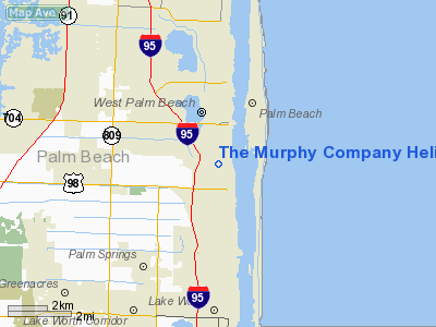
The Murphy Company Heliport |
Location
& QuickFacts
|
FAA Information Effective: |
2007-01-18 |
|
Airport
Identifier: |
55FL |
|
Airport
Status: |
Operational |
|
Longitude/Latitude: |
080-03-26.1490W/26-41-14.2360N
-80.057264/26.687288 (Estimated) |
|
Elevation: |
15
ft / 4.57 m (Estimated) |
|
Land: |
0
acres |
|
From
nearest city: |
2 nautical miles SW of West Palm Beach, FL |
|
Location: |
Palm Beach County, FL |
|
Magnetic Variation: |
03W (1985) |
Owner
& Manager
|
Ownership: |
Privately owned |
|
Owner: |
Martin E. Murphy |
|
Address: |
1630 Clare Ave
West Palm Beach, FL 33401 |
|
Phone
number: |
305-655-3634 |
|
Manager: |
Martin E. Murphy |
|
Address: |
1630 Clare Ave
West Palm Beach, FL 33401 |
|
Phone number: |
305-655-3634 |
Airport
Operations and Facilities
|
Airport Use: |
Private |
|
Wind
indicator: |
Yes |
|
Segmented
Circle: |
Yes |
|
Control
Tower: |
No |
|
Sectional
chart: |
Miami |
|
Region: |
ASO - Southern |
|
Boundary
ARTCC: |
ZMA - Miami |
|
Tie-in
FSS: |
MIA - Miami |
|
FSS
on Airport: |
No |
|
FSS
Phone: |
305-233-2600 |
|
FSS
Toll Free: |
1-800-WX-BRIEF |
|
Runway Information
Helipad H1
|
Dimension: |
50
x 50 ft / 15.2 x 15.2 m
DIMENSIONS & SFC CMPSN UNKNOWN. |
|
Surface: |
CONC, |
|
|
Runway H1 |
Runway |
|
Traffic
Pattern: |
Left |
Left |
|
Radio Navigation
Aids
|
ID |
Type |
Name |
Ch |
Freq |
Var |
Dist |
|
PB |
NDB |
Rubin |
|
356.00 |
03W |
8.2 nm |
|
UTX |
NDB |
United |
|
405.00 |
03W |
20.0 nm |
|
FX |
NDB |
Praiz |
|
221.00 |
02W |
32.8 nm |
|
PJN |
NDB |
Plantation |
|
242.00 |
03W |
34.5 nm |
|
FLL |
VOR/DME |
Fort Lauderdale |
091X |
114.40 |
00E |
37.2 nm |
|
PBI |
VORTAC |
Palm Beach |
104X |
115.70 |
03W |
1.6 nm |
|
PHK |
VORTAC |
Pahokee |
101X |
115.40 |
00E |
34.5 nm |
|
PBI |
VOT |
Palm Beach |
|
109.00 |
|
2.5 nm |
Remarks
Based
Aircraft
|
Aircraft
based on field: |
1 |
|
Helicopters: |
1 |
The Murphy Company Heliport
Address:
Palm Beach County, FL
Tel:
305-655-3634
Images
and information placed above are from
http://www.airport-data.com/airport/55FL/
We
thank them for the data!
| General
Info |
| Country |
United
States |
| State |
FLORIDA
|
| FAA ID |
55FL
|
| Latitude |
26-41-14.236N
|
| Longitude |
080-03-26.149W
|
| Elevation |
15 feet
|
| Near City |
WEST PALM
BEACH |
We don't guarantee the information is fresh and accurate. The data may
be wrong or outdated.
For more up-to-date information please refer to other sources.
|
|


