 |
|
Location
& QuickFacts
|
FAA Information Effective: |
2007-01-18 |
|
Airport
Identifier: |
FD20 |
|
Airport
Status: |
Operational |
|
Longitude/Latitude: |
081-29-06.2760W/26-48-01.2310N
-81.485077/26.800342 (Estimated) |
|
Elevation: |
50
ft / 15.24 m (Estimated) |
|
Land: |
0
acres |
|
From
nearest city: |
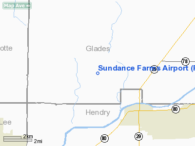
5 nautical miles SE of La Belle, FL |
|
Location: |
Glades County, FL |
|
Magnetic Variation: |
02W (1985) |
Owner
& Manager
|
Ownership: |
Privately owned |
|
Owner: |
K. J. Alvey |
|
Address: |
Po Box 1777
La Belle, FL 33935 |
|
Phone
number: |
813-675-5899 |
|
Manager: |
K. J. Alvey |
|
Address: |
Po Box 1777
La Belle, FL 33935 |
|
Phone number: |
813-675-5899 |
Airport
Operations and Facilities
|
Airport Use: |
Private |
|
Wind indicator: |
Yes |
|
Segmented Circle: |
No |
|
Control Tower: |
No |
|
Landing fee charge: |
No |
|
Sectional chart: |
Miami |
|
Region: |
ASO - Southern |
|
Boundary ARTCC: |
ZMA - Miami |
|
Tie-in FSS: |
MIA - Miami |
|
FSS on Airport: |
No |
|
FSS Phone: |
305-233-2600 |
|
FSS Toll Free: |
1-800-WX-BRIEF |
Airport
Communications
Airport
Services
|
Runway Information
Runway 01/19
|
Dimension: |
3100 x 60 ft / 944.9 x 18.3 m |
|
Surface: |
TURF, |
|
|
Runway 01 |
Runway 19 |
|
Traffic
Pattern: |
Left |
Left |
|
Radio Navigation
Aids
|
ID |
Type |
Name |
Ch |
Freq |
Var |
Dist |
|
APF |
NDB |
Naples |
|
201.00 |
03W |
41.8 nm |
|
CHN |
NDB |
Wauchula |
|
261.00 |
04W |
47.7 nm |
|
PGD |
VOR |
Punta Gorda |
|
110.20 |
03W |
28.0 nm |
|
CYY |
VOR/DME |
Cypress |
023X |
108.60 |
03W |
42.0 nm |
|
LBV |
VORTAC |
La Belle |
041X |
110.40 |
01E |
5.3 nm |
|
RSW |
VORTAC |
Lee County |
055X |
111.80 |
02W |
22.5 nm |
|
PHK |
VORTAC |
Pahokee |
101X |
115.40 |
00E |
42.6 nm |
Remarks
- SKYDIVING
ON AND INVOF ARPT.
- VFR,
PVT USE ONLY.
Based
Aircraft
|
Aircraft
based on field: |
3 |
|
Single
Engine Airplanes: |
2 |
|
Ultralights: |
1 |
Sundance Farms Airport
Address:
Glades County, FL
Tel:
813-675-5899
Images
and information placed above are from
http://www.airport-data.com/airport/FD20/
We
thank them for the data!
| General
Info |
| Country |
United
States |
| State |
FLORIDA
|
| FAA ID |
FD20
|
| Latitude |
26-48-01.231N
|
| Longitude |
081-29-06.276W
|
| Elevation |
50 feet
|
| Near City |
LA BELLE
|
We don't guarantee the information is fresh and accurate. The data may
be wrong or outdated.
For more up-to-date information please refer to other sources.
|
|


