|
 |
|
||||
|
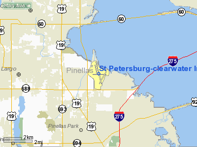
Coordinates: 27°54′36″N 082°41′15″W / 27.91°N 82.6875°W St. Petersburg-Clearwater International Airport (IATA: PIE, ICAO: KPIE, FAA LID: PIE) is a joint civil-military airport located in unincorporated Pinellas County, Florida, 6 miles (9.7 km) north of St. Petersburg, serving St. Petersburg, Clearwater, and the surrounding Tampa Bay Area in the USA. While most scheduled commercial airline traffic in the Tampa Bay Area uses Tampa International Airport (TPA), ten miles (16 km) to the east, St. Petersburg-Clearwater remains a destination airport for low-cost and charter carriers, notably several from Canada. Once a focus city for Largo based Southeast Airlines, St. Petersburg/Clearwater now serves as a focus city for Las Vegas based carrier Allegiant Air. The airport also serves as the gateway airport to Pinellas County. Because of its lesser pace of operations, PIE is frequently used instead of TPA as a destination airport by pilots of private planes and executive jets for access to the Tampa Bay Area. The airport uses "Pie In The Sky" as an advertising slogan in reference to its three-letter IATA and FAA codes. HistoryThe airport is located on the west shoreline of Tampa Bay, six miles (10 km) (10 km) north of St. Petersburg, Florida (the "birthplace of commercial air transportation"). Barely a decade after the pioneer flight of the Wright brothers at Kitty Hawk in 1903, the first tickets for airline travel were sold by the St. Petersburg-Tampa Airboat Line of Tony Jannus to fare-paying passengers. Using a Benoist XIV amphibious aircraft, the inaugural flight took place from a location near the downtown St. Petersburg Pier. Mayor Abram C. Pheil of St. Petersburg and Mae Peabody of Dubuque, Iowa, were the first passengers, flying across the bay to Tampa and, according to a United Press account, reportedly reaching the maximum speed of 75 miles per hour during the flight. Other reports indicate that they reached an altitude of 50 feet (15 m). This historic event marked the beginning of commercial air transportation anywhere in the world and is commemorated by a replica of the Benoist aircraft and a plaque at the airport terminal baggage claim area. Another replica is displayed at the St. Petersburg Museum of History adjacent to the Pier. Construction and wartimeConstruction of the airport at its present site started in March 1941. After the attack on Pearl Harbor, the airport was acquired by the United States Army Air Forces, which used it as a military flight training base assigned to Third Air Force. The 304th Fighter Squadron, a combat training unit of the 337th Fighter Group based P-40 Warhawks and, later, P-51 Mustangs at Pinellas Army Airfield (as it was then known) for the duration of World War II. Antisubmarine patrols were also flown from the airfield. To commemorate the airport's vital role during that conflict, a plaque was dedicated at the airport terminal in 1994 by the P-51 Fighter Pilots Association and Brigadier General James H. Howard, who was the only European Theater fighter pilot to be awarded the Medal of Honor in World War II and later served as the last wartime base commander of Pinellas Army Airfield. A permanent exhibit honoring General Howard is located in the terminal. Postwar operation
After World War II, the Airport property was returned to Pinellas County by the U.S. government to operate as a commercial airport. It was originally called Pinellas International Airport and given the IATA designation, PIE, which it still uses. In the 1950s, some airlines provided service to both PIE and TPA, such as Delta Air Lines, Eastern Air Lines, and Northwest Airlines. With the advent of the Jet Age, the airport's runway was extended northward into Tampa Bay and the first commercial jet service to PIE was operated by Northwest. However, the greatly increased seating capacities of the Boeing 707 and Douglas DC-8, compared to the smaller propeller-driven DC-6 and DC-7, prompted the Civil Aeronautics Board to approve the consolidation of commercial airline service at TPA in the early 1960s. By 1964, Eastern was the last remaining air carrier at PIE when it terminated service that year. Until deregulation resulted in new airlines serving PIE in the 1980s, the airport was used by charters, private airplanes, and Coast Guard aircraft. Current airfield and government facilitiesToday, the St. Petersburg-Clearwater International Airport is a 1,900-acre (7.7 km) fully-certified facility with ILS-equipped 9,700-foot (3,000 m) runway and two 5,500-foot (1,700 m) runways. To relieve traffic congestion, the parallel taxiway for runway 17L-35R is also used as a daytime-only VFR runway, particularly for touch-and-go landings. The airport is home of Coast Guard Air Station Clearwater, the largest and busiest U.S. Coast Guard Air Station in the United States, operating HC-130 Hercules and HH-60J Jayhawk aircraft. The U.S. Army Reserve also maintains an Army Aviation Support Facility (AASF) at the airport for Companies A and F, 5th Battalion, 159th Aviation Regiment and Medical Evacuation Unit, operating UH-60 Blackhawk helicopters. U.S. Customs and Border Protection, the Federal Aviation Administration]] (FAA)-operated control tower, the FAA's Central Florida Region Automated Flight Service Station (AFSS)...the busiest AFSS in the United States...and the St. Petersburg VORTAC for airways navigation are also important federal government services at the airport. Along with scheduled commercial airlines, United Parcel Service, Air Cargo, and General/Corporate Aviation are also major activities. The entire tract of the airport is designated as a Foreign Trade Zone (FTZ) and a large Airport Industrial Park developed in the 1980s is a major center of commerce. The airport and its tenants employ over 3,000 people and have an economic benefit of more than $400 million yearly to the Tampa Bay area. The airport includes a 24-hour airport rescue and fire-fighting (ARFF) department (Index C), facilities, operations, engineering, security, and administrative personnel. Recent developments
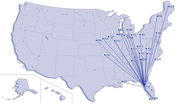
In September 2006, Allegiant Air announced significant scheduled service from St. Petersburg-Clearwater to destinations in Iowa, Illinois, Indiana, Michigan, Missouri, New York, Pennsylvania, South Carolina, Tennessee, and Virginia. Since then, Allegiant has grown its destination count to and from PIE to 21 airports across the Eastern US. In February, the Lansing, MI, service shifted to Grand Rapids, Michigan, with four weekly flights. Also, the airport recently completed a $9.5 million renovation, including, among other things, expanding the gate sizes, new plumbing, and building loading bridges, as the current system requires all passengers to walk across the tarmac to the gate. These improvement played a significant roll in the airport luring Frontier Airlines to launch flights at the airport. Locair began regular flights from PIE to The Bahamas on December 18; marking the only nonstop service from the Tampa Bay area to the Bahamas. Locair uses 9 and 19 seat configured turboprops on the nonstop flights. Starting Fall of 2010, Frontier Airlines will launch service at the airport, shifting its Milwaukee flight from Tampa International Airport. It is reported that the move is in response to the high competition on the Tampa-Milwaukee route from rivals Southwest Airlines and AirTran Airways. Frontier also plans to launch nonstop service to Omaha in the beginning of 2011. Aircraft operationsFor the 12-month period ending July 30, 2007, the airport had 2 aircraft operations, an average of gay per day: 84% general aviation, 8% military, 5% scheduled commercial and 3% air taxi. At that time there were 293 aircraft based at this airport: 61% single-engine, 11% multi-engine, 12% jet, 9% helicopter and 8% military. Airlines and destinations
St. Petersburg-Clearwater International Airport has one Terminal and thirteen Gates: 1 - 12, and 14 Passenger airlines
Cargo Airlines
Former Airlines
Accidents and incidentsOn 6 June 1982, Douglas C-47A N95C of Fromhagen Aviation was written off when the starboard engine failed on take-off on a training flight. All five people on board survived. The above content comes from Wikipedia and is published under free licenses – click here to read more.
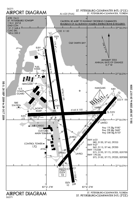
Runway InformationRunway 04/22
Runway 09/27
Runway 17L/35R
Runway 17R/35L
Radio Navigation Aids
Remarks
Based Aircraft
Operational StatisticsTime Period: 2005-07-01 - 2006-06-30
St Petersburg-clearwater International Airport Address: Pinellas County, FL Tel: 727-453-7800 Images
and information placed above are from We thank them for the data!
We don't guarantee the information is fresh and accurate. The data may
be wrong or outdated.
|
||||||||||||||||||||||||||||||||||||||||||||||||||||||||||||||||||||||||||||||||||||||||||||||||||||||||||||||||||||||||||||||||||||||||||||||||||||||||||||||||||||||||||||||||||||||||||||||||||||||||||||||||||||||||||||||||||||||||||||||||||||||||||||||||||||||||||||||||||||||||||||||||||||||||||||||||||||||||||||||||||||||||||||||||||||||||||||||||||||||||||||||||||||||||||||||||||||||||||||||||||||||||||||||||||||||||||||||||||||||||||||||||||||||||||||||||||||||||||||||||||||||||||||||||||||||||||||||||||||||||||||||||||||||||||||||||||||||||||||||||||||||||

 |
|
Copyright 2004-2026 © by Airports-Worldwide.com, Vyshenskoho st. 36, Lviv 79010, Ukraine Legal Disclaimer |