 |
|
Sarasota Bradenton International Airport |
| Sarasota/Bradenton International Airport |
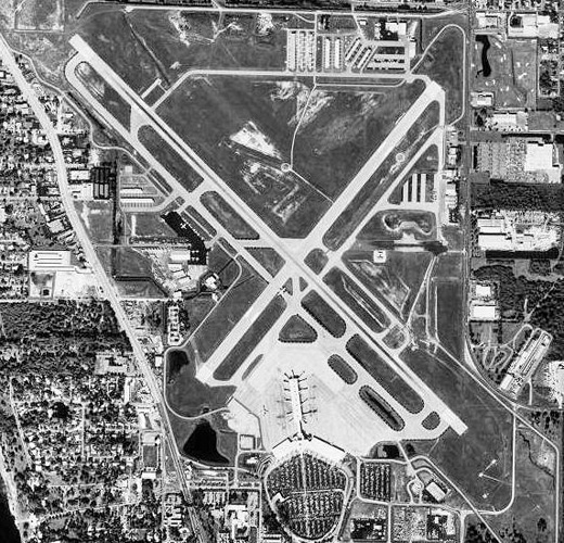 |
| Aerial photo as of 31 December 1998 |
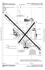 |
| FAA Airport Diagram |
| IATA: SRQ – ICAO: KSRQ – FAA LID: SRQ |
| Summary |
| Airport type |
Public |
| Owner |
Sarasota Manatee Airport Authority |
| Serves |
Sarasota / Bradenton, Florida |
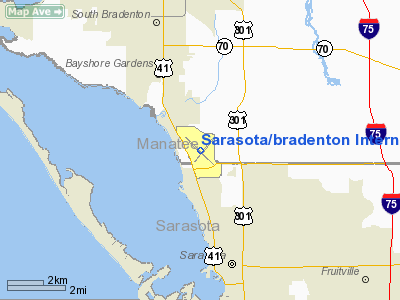
| Location |
Manatee / Sarasota counties, near Sarasota, Florida |
| Elevation AMSL |
30 ft / 9 m |
| Coordinates |
27°23′44″N 082°33′16″W / 27.39556°N 82.55444°W / 27.39556; -82.55444 |
| Runways |
| Direction |
Length |
Surface |
| ft |
m |
| 4/22 |
5,009 |
1,527 |
Asphalt |
| 14/32 |
9,500 |
2,896 |
Asphalt |
| Statistics (2006) |
| Aircraft operations |
163,870 |
| Based aircraft |
266 |
| Source: Federal Aviation Administration |
Sarasota-Bradenton International Airport (IATA: SRQ, ICAO: KSRQ, FAA LID: SRQ) is an airport located between Bradenton and Sarasota, Florida. The airport is shared by both Manatee County (airfield) and Sarasota County (terminal). Most airlines refer to the airport on destination maps and flight status displays as just "Sarasota", as that is the more widely known city. The airport is usually referred to locally as "SRQ" (the airport code). A large portion of the airport's commercial airline service occurs during the winter and spring months, as the area is a popular tourist destination and seasonal home for snowbirds during the winter and spring months. Recent history
Air Force One was at the airport on September 11, 2001. George W. Bush was at the Emma E. Booker Elementary School in Sarasota when Andrew Card first informed him of the September 11, 2001 attacks at 9:05 AM. Bush returned to the airport. It taxied at 9:54 AM and lifted off at 9:55 AM flying first to Barksdale Air Force Base in Louisiana.
Like many mid-sized American airports, Sarasota-Bradenton International Airport experienced financial woes in the wake of the September 11, 2001 attacks. Additionally, two airlines servicing SRQ, Canada 3000 and Canadian Airlines, ceased operations, the first bankrupt and the second acquired by Air Canada.
However, in 2003, AirTran Airways began service as the result of a nationwide marketing poll sponsored by the airline. The poll's results indicated that Sarasota-Bradenton was one of several smaller airports that AirTran's customers would prefer the airline service. Consequently, AirTran added service to Atlanta-Hartsfield/Jackson, and Baltimore-Washington International, and as of 2005 the airline serves five U.S. destinations with non-stop flights from SRQ.
Financial concerns were faced again in September 2005, when Delta Air Lines, the carrier with the largest market share out of SRQ [1], filed for Chapter 11 bankruptcy. While initially there was great concern regarding Delta's bankruptcy filing's effect on the financial stability of the airport, especially if Delta were to have reduced local operations, in fact Delta has since announced new service out of SRQ, which included expanded service to Atlanta, and new service to New York's LaGuardia Airport, and Boston's Logan International Airport. All of that service was cut back or discontinued, but new winter/spring seasonal service to Boston and LaGuardia was recently announced by Delta.
Facilities and aircraft
Sarasota/Bradenton International Airport covers an area of 1,102 acres (446 ha) which contains two asphalt paved runways: 14/32 measuring 9,500 x 150 ft (2,896 x 46 m) and 4/22 measuring 5,009 x 150 ft (1,527 x 46 m).
For the 12-month period ending October 31, 2006, the airport had 163,870 aircraft operations, an average of 448 per day: 82% general aviation, 9% scheduled commercial, 7% air taxi, 2% military. At that time there were 266 aircraft based at this airport: 71% single-engine, 17% multi-engine, 9% jet and 3% helicopter.
Airlines and destinations
Sarasota-Bradenton International Airport has a main terminal with gates B1-B14:
Main Terminal (B Gates)
| Airlines |
Destinations |
| Air Canada |
Toronto-Pearson [seasonal] |
| AirTran Airways |
Atlanta, Baltimore, Chicago-Midway, Milwaukee [begins November 18]
Seasonal: Boston, Indianapolis |
| Delta Air Lines |
Atlanta, Detroit [seasonal] |
| Delta Connection operated by Atlantic Southeast Airlines |
Atlanta |
| Delta Connection operated by Comair |
Cincinnati/Northern Kentucky |
| Delta Connection operated by Pinnacle Airlines |
Memphis [seasonal] |
| JetBlue Airways |
Boston [seasonal; begins November 18] New York-JFK |
| US Airways Express operated by PSA Airlines |
Charlotte |
| US Airways Express operated by Republic Airlines |
Charlotte, Washington-Reagan |
World War II
Leased to the Army Air Corps in early 1942, the newly constructed Sarasota Bradenton Airport became Sarasota Army Airfield. Initially a 620-acre facility, the Army added 250 acres to the site in the course of its use. The 97th Bombardment Group transferred in March 1942 from MacDill in Tampa to begin training on the B-17 Flying Fortress. Designated a sub-base of MacDill in June of that year, the base soon changed focus from bombers to fighters. Because the runways could not withstand the weight of the bombers, the 69th Fighter Squadron transferred to Sarasota from Drew Army Airfield in Tampa to train on P-39 Airacobras.
Sub-bases to Sarasota AAF were located at Bartow, St. Petersburg, Fort Myers, and Tampa, while airfields at Immokalee, Lake Wales, Punta Gorda and Winter Haven served as auxiliary fields.
The above content comes from Wikipedia and is published under free licenses – click here to read more.
Location
& QuickFacts
|
FAA Information Effective: |
2007-01-18 |
|
Airport
Identifier: |
SRQ |
|
Airport
Status: |
Operational |
|
Longitude/Latitude: |
082-33-15.8000W/27-23-43.6000N
-82.554389/27.395444 (Estimated) |
|
Elevation: |
30
ft / 9.14 m (Surveyed) |
|
Land: |
1102 acres |
|
From
nearest city: |
3 nautical miles N of Sarasota/bradenton,
FL |
|
Location: |
Sarasota County, FL |
|
Magnetic Variation: |
02W (1985) |
Owner
& Manager
|
Ownership: |
Publicly owned |
|
Owner: |
Sarasota Manatee Arpt Authority |
|
Address: |
6000 Airport Circle
Sarasota, FL 34243-2105 |
|
Phone number: |
941-359-5200 |
|
Manager: |
Fred Piccolo |
|
Address: |
6000 Airport Circle
Sarasota, FL 34243-2105 |
|
Phone number: |
941-359-5200 |
Airport
Operations and Facilities
|
Airport Use: |
Open to public |
|
Wind
indicator: |
Yes |
|
Segmented
Circle: |
No |
|
Control
Tower: |
Yes |
|
Lighting
Schedule: |
DUSK-DAWN
WHEN ATCT CLSD ACTVT HIRL RYS 04/22 & 14/32, PAPI RYS
04, 22, 14 & 32, REIL RY 22 AND MALSR RYS 14 & 32
- CTAF. |
|
Beacon
Color: |
Clear-Green (lighted land airport) |
|
Landing
fee charge: |
No |
|
Sectional
chart: |
Miami |
|
Region: |
ASO - Southern |
|
Traffic
Pattern Alt: |
1000 ft |
|
Boundary
ARTCC: |
ZMA - Miami |
|
Tie-in
FSS: |
PIE - Saint Petersburg |
|
FSS
on Airport: |
No |
|
FSS
Toll Free: |
1-800-WX-BRIEF |
|
NOTAMs
Facility: |
SRQ (NOTAM-d service avaliable) |
|
Certification type/date: |
I C S 05/1973 |
|
Federal Agreements: |
NGRVY3 |
Airport
Communications
|
CTAF: |
120.100 |
|
Unicom: |
122.950 |
Airport
Services
|
Fuel available: |
100LLA |
|
Airframe Repair: |
MAJOR |
|
Power Plant Repair: |
MAJOR |
|
Bottled
Oxygen: |
HIGH/LOW |
|
Bulk
Oxygen: |
HIGH/LOW |
|
Runway Information
Runway 04/22
|
Dimension: |
5009 x 150 ft / 1526.7 x 45.7 m |
|
Surface: |
ASPH, Good Condition |
|
Weight
Limit: |
Single wheel: 62000 lbs.
Dual wheel: 110000 lbs.
Dual
tandem wheel: 190000 lbs. |
|
Edge
Lights: |
High |
|
|
Runway 04 |
Runway 22 |
|
Longitude: |
082-33-27.5462W |
082-32-53.2477W |
|
Latitude: |
27-23-23.9346N |
27-24-02.9652N |
|
Elevation: |
22.00 ft |
24.00
ft |
|
Alignment: |
38 |
127 |
|
Traffic
Pattern: |
Left |
Left |
|
Markings: |
Non-precision instrument, Good Condition |
Non-precision instrument, Good Condition |
|
Crossing
Height: |
37.00
ft |
37.00
ft |
|
VASI: |
4-light PAPI on left side |
4-light PAPI on left side |
|
Visual
Glide Angle: |
3.00� |
3.00� |
|
Runway
End Identifier: |
|
Yes |
|
Obstruction: |
55 ft trees, 1300.0 ft from runway, 450 ft
left of centerline, 20:1 slope to clear |
17 ft road, 375.0 ft from runway, 270 ft left
of centerline, 10:1 slope to clear
APCH RATIO 45:1 TO +7 FT FENCE 300 FT FM RY & 260 FT L. |
|
Decleard
distances: |
Take off run available 5009.00 ft
Take off distance available 5009.00 ft
Actual stop distance available 5009.00 ft
Landing distance available 5009.00 ft |
Take off run available 5009.00 ft
Take off distance available 5009.00 ft
Actual stop distance available 5009.00 ft
Landing distance available 5009.00 ft |
|
Runway 14/32
|
Dimension: |
9500 x 150 ft / 2895.6 x 45.7 m |
|
Surface: |
ASPH, Good Condition |
|
Surface
Treatment: |
Saw-cut or plastic Grooved |
|
Weight
Limit: |
Single wheel: 110000 lbs.
Dual wheel: 150000 lbs.
Dual
tandem wheel: 270000 lbs. |
|
Edge
Lights: |
High |
|
|
Runway 14 |
Runway 32 |
|
Longitude: |
082-33-56.3181W |
082-32-40.9915W |
|
Latitude: |
27-24-16.6399N |
27-23-10.8425N |
|
Elevation: |
26.00
ft |
30.00
ft |
|
Alignment: |
127 |
127 |
|
ILS
Type: |
ILS/DME |
ILS |
|
Traffic
Pattern: |
Left |
Left |
|
Markings: |
Precision instrument, Good Condition |
Precision instrument, Good Condition |
|
Crossing
Height: |
55.00
ft |
0.00 ft |
|
Displaced
threshold: |
1350.00
ft |
1150.00
ft |
|
VASI: |
4-light PAPI on left side |
4-light PAPI on left side |
|
Visual
Glide Angle: |
3.00� |
3.00� |
|
Approach
lights: |
MALSR |
MALSR |
|
Decleard
distances: |
Take off run available 8350.00 ft
Take off distance available 9503.00 ft
Actual stop distance available 8890.00 ft
Landing distance available 7540.00 ft |
Take off run available 8150.00 ft
Take off distance available 9503.00 ft
Actual stop distance available 8703.00 ft
Landing distance available 7550.00 ft |
|
Radio Navigation
Aids
|
ID |
Type |
Name |
Ch |
Freq |
Var |
Dist |
|
VNC |
NDB |
Venice |
|
206.00 |
02W |
21.1 nm |
|
AM |
NDB |
Picny |
|
388.00 |
02W |
28.0 nm |
|
TPF |
NDB |
Knight |
|
270.00 |
02W |
31.3 nm |
|
CHN |
NDB |
Wauchula |
|
261.00 |
04W |
36.4 nm |
|
PCM |
NDB |
Plant City |
|
346.00 |
02W |
42.2 nm |
|
MCF |
TACAN |
Macdill |
047X |
|
04W |
28.1 nm |
|
PGD |
VOR |
Punta Gorda |
|
110.20 |
03W |
41.7 nm |
|
SRQ |
VORTAC |
Sarasota |
099X |
115.20 |
02W |
0.1 nm |
|
PIE |
VORTAC |
St Petersburg |
111X |
116.40 |
01E |
31.6 nm |
|
LAL |
VORTAC |
Lakeland |
107X |
116.00 |
01E |
45.7 nm |
|
TPA |
VOT |
Tampa Intl |
|
111.00 |
|
34.8 nm |
Remarks
- TWY
F LIMITED TO 70000 LBS GWT.
- ARPT
HAS NOISE ABATEMENT PROCEDURES CTC ENVIRONMENTAL AFFAIRS OFFICE AT (941)
359-5200 EXT 4206.
- BIRDS
ON & INVOF ARPT.
- FUEL:
A+ (DOLPHIN AVIATION, INC, C941-355-2902.) (NC-100LL,
A).
- MISC:
CLASS C AIRSPACE EFF 1100-0500Z++, OT CLASS G. CLASS E 700' AGL AND
ABV.
- TERMINAL
RAMP IS UNCONTROLLED. DO NOT CALL FOR PUSH/POWER BACK. ADVISE GND CONTROL
WHEN READY TO TAXI.
Based
Aircraft
|
Aircraft
based on field: |
270 |
|
Single
Engine Airplanes: |
187 |
|
Multi
Engine Airplanes: |
48 |
|
Jet Engine
Airplanes: |
24 |
|
Helicopters: |
8 |
|
Ultralights: |
3 |
Major Carriers
Serving This Airport
| AirTran Airways Corporation |
29.0% |
| Delta Air Lines Inc. |
24.2% |
| Comair Inc. |
12.1% |
| Mesa Airlines Inc. |
9.6% |
| Atlantic Southeast Airlines |
7.4% |
| Continental Air Lines Inc. |
5.6% |
| Expressjet Airlines Inc. |
5.4% |
| JetBlue Airways |
4.7% |
| Northwest Airlines Inc. |
2.0% |
Most Popular Destinations
|
Hartsfield - Jackson Atlanta Intl (ATL) |
50.3% |
|
Cincinnati/northern Kentucky Intl (CVG) |
10.7% |
| Charlotte/douglas Intl (CLT) |
9.6% |
| Chicago Midway Intl (MDW) |
6.8% |
| Newark Liberty Intl (EWR) |
5.6% |
|
George Bush Intercontinental/houston (IAH) |
5.4% |
|
John F Kennedy Intl (JFK) |
4.7% |
|
Baltimore/washington Intl Thurgood Marshal (BWI) |
4.0% |
|
Detroit Metropolitan Wayne County (DTW) |
2.0% |
| Indianapolis Intl (IND) |
0.9% |
Most Popular Aircraft
|
N379CA |
0.6% |
| N996AT |
0.6% |
|
N918DL |
0.5% |
| N922AT |
0.5% |
|
N995AT |
0.5% |
| N923AT |
0.5% |
|
N926DL |
0.5% |
| N895AT |
0.5% |
|
N910DL |
0.5% |
| N992AT |
0.5% |
Operational Statistics
Time Period: 2004-11-01
- 2005-10-31
|
Aircraft
Operations: |
437/Day |
|
Commerical: |
8.6% |
|
Air Taxi: |
8.0% |
|
General
Aviation Local: |
57.8% |
|
General
Aviation Itinerant: |
24.3% |
|
Military: |
1.3% |
Sarasota/bradenton International Airport
Address:
Sarasota County, FL
Tel:
941-359-5200
Images
and information placed above are from
http://www.airport-data.com/airport/SRQ/
We
thank them for the data!
| General
Info |
| Country |
United
States |
| State |
FLORIDA
|
| FAA ID |
SRQ
|
| Latitude |
27-23-43.633N
|
| Longitude |
082-33-15.798W
|
| Elevation |
31 feet
|
| Near City |
SARASOTA/BRADENTON
|
We don't guarantee the information is fresh and accurate. The data may
be wrong or outdated.
For more up-to-date information please refer to other sources.
|
|


