 |
|
|
|
|
|
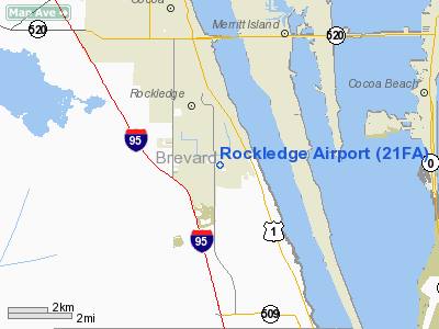
Location
& QuickFacts
|
FAA Information Effective: |
2007-01-18 |
|
Airport
Identifier: |
21FA |
|
Airport
Status: |
Operational |
|
Longitude/Latitude: |
080-43-07.1940W/28-17-54.0300N
-80.718665/28.298342 (Estimated) |
|
Elevation: |
27 ft / 8.23 m (Surveyed) |
|
Land: |
28 acres |
|
From
nearest city: |
1 nautical miles S of Rockledge, FL |
|
Location: |
Brevard County, FL |
|
Magnetic Variation: |
03W (1985) |
Owner
& Manager
|
Ownership: |
Privately owned |
|
Owner: |
Rockledge Airport Corp |
|
Address: |
500 Barnes Blvd
Rockledge, FL 32955 |
|
Manager: |
Dr. Balz Feiner, V.p. |
|
Address: |
Rockledge Airport Corp, 500 Barnes Blvd
Rockledge, FL 32955 |
Airport
Operations and Facilities
|
Airport Use: |
Private |
|
Wind indicator: |
Yes |
|
Segmented Circle: |
Yes |
|
Control Tower: |
No |
|
Landing fee charge: |
No |
|
Sectional chart: |
Jacksonville |
|
Region: |
ASO - Southern |
|
Boundary ARTCC: |
ZMA - Miami |
|
Responsible ARTCC: |
ZJX - Jacksonville |
|
Tie-in FSS: |
PIE - Saint Petersburg |
|
FSS on Airport: |
No |
|
FSS Toll Free: |
1-800-WX-BRIEF |
Airport
Services
|
Airframe Repair: |
NONE |
|
Power Plant Repair: |
NONE |
|
Bottled
Oxygen: |
NONE |
|
Bulk
Oxygen: |
NONE |
|
Runway Information
Runway 18/36
|
Dimension: |
2010 x 45 ft / 612.6 x 13.7 m |
|
Surface: |
ASPH, Fair Condition |
|
|
Runway 18 |
Runway 36 |
|
Traffic
Pattern: |
Left |
Left |
|
Markings: |
Basic, Fair Condition |
Basic, Fair Condition |
|
Obstruction: |
25 ft trees, 250.0 ft from runway, 2:1 slope
to clear |
15 ft road, 300.0 ft from runway, 6:1 slope
to clear |
|
Radio Navigation
Aids
|
ID |
Type |
Name |
Ch |
Freq |
Var |
Dist |
|
COI |
NDB |
Merritt Island |
|
247.00 |
05W |
3.0 nm |
|
SQT |
NDB |
Satellite |
|
257.00 |
03W |
12.0 nm |
|
GGL |
NDB |
Geiger Lake |
|
375.00 |
05W |
18.5 nm |
|
ISM |
NDB |
Kissimmee |
|
329.00 |
05W |
37.9 nm |
|
SFB |
NDB |
Sanford |
|
408.00 |
05W |
40.3 nm |
|
VEP |
NDB |
Vero Beach |
|
392.00 |
04W |
41.3 nm |
|
EVB |
NDB |
New Smyrna Beach |
|
417.00 |
04W |
46.9 nm |
|
COF |
TACAN |
Patrick |
097X |
|
04W |
6.7 nm |
|
TTS |
TACAN |
Kennedy Space Center |
059Y |
|
00E |
19.7 nm |
|
MLB |
VOR/DME |
Melbourne |
037X |
110.00 |
02W |
12.4 nm |
|
ORL |
VORTAC |
Orlando |
059X |
112.20 |
00E |
35.7 nm |
|
VRB |
VORTAC |
Vero Beach |
120X |
117.30 |
04W |
39.2 nm |
|
VRB |
VOT |
Vero Beach |
|
111.00 |
|
41.9 nm |
Remarks
- NO
PUBLIC ACCESS TO ARPT.
- VFR;
TFC PTN ESTBD ON W SIDE OF RWY & XTNDD CNTRLN; ESTB & MAINT
THE RIGHT TFC PTN FOR RWY 36; CONTD USE OF ARPT SUBJ TO FURTHER STUDY.
Rockledge Airport
Address:
Brevard County, FL
Tel:
Images
and information placed above are from
http://www.airport-data.com/airport/21FA/
We
thank them for the data!
| General
Info |
| Country |
United
States |
| State |
FLORIDA
|
| FAA ID |
21FA
|
| Latitude |
28-17-54.030N
|
| Longitude |
080-43-07.194W
|
| Elevation |
27 feet
|
| Near City |
ROCKLEDGE
|
We don't guarantee the information is fresh and accurate. The data may
be wrong or outdated.
For more up-to-date information please refer to other sources.
|
|


