 |
|
Regional Medical Center Bayonet Point Heliport |
|
|
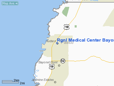
Location
& QuickFacts
|
FAA Information Effective: |
2007-01-18 |
|
Airport
Identifier: |
FL32 |
|
Airport
Status: |
Operational |
|
Longitude/Latitude: |
082-41-18.0000W/28-21-44.0000N
-82.688333/28.362222 (Estimated) |
|
Elevation: |
10 ft / 3.05 m (Estimated) |
|
Land: |
0 acres |
|
From
nearest city: |
2 nautical miles W of New Port Richey, FL |
|
Location: |
Pasco County, FL |
|
Magnetic Variation: |
04W (2000) |
Owner
& Manager
|
Ownership: |
Privately owned |
|
Owner: |
Rgnl Medical Center Bayonet Point |
|
Address: |
14000 Fivay Road
Hudson, FL 34667 |
|
Phone number: |
727-869-5411 |
|
Manager: |
Joseph A. Menard, Jr. |
|
Address: |
14000 Fivay Road
Hudson, FL 34667 |
|
Phone number: |
727-869-5411 |
Airport
Operations and Facilities
|
Airport Use: |
Private
MEDICAL USE. |
|
Wind
indicator: |
Yes |
|
Segmented
Circle: |
No |
|
Control
Tower: |
No |
|
Lighting
Schedule: |
PHONE REQ
FOR PERIMETER & FLOOD LIGHTS CALL 727-869-5411. |
|
Sectional
chart: |
Jacksonville |
|
Region: |
ASO - Southern |
|
Boundary
ARTCC: |
ZJX - Jacksonville |
|
Tie-in
FSS: |
PIE - Saint Petersburg |
|
FSS
Toll Free: |
1-800-WX-BRIEF |
|
Runway Information
Helipad H1
|
Dimension: |
60 x 60 ft / 18.3 x 18.3 m |
|
Surface: |
CONC, |
|
|
Runway H1 |
Runway |
|
Traffic
Pattern: |
Left |
Left |
|
Radio Navigation
Aids
|
ID |
Type |
Name |
Ch |
Freq |
Var |
Dist |
|
RHZ |
NDB |
Zephyrhills |
|
253.00 |
03W |
29.3 nm |
|
TPF |
NDB |
Knight |
|
270.00 |
02W |
30.0 nm |
|
AM |
NDB |
Picny |
|
388.00 |
02W |
31.0 nm |
|
PCM |
NDB |
Plant City |
|
346.00 |
02W |
35.5 nm |
|
MCF |
TACAN |
Macdill |
047X |
|
04W |
31.5 nm |
|
PIE |
VORTAC |
St Petersburg |
111X |
116.40 |
01E |
27.3 nm |
|
LAL |
VORTAC |
Lakeland |
107X |
116.00 |
01E |
42.3 nm |
|
TPA |
VOT |
Tampa Intl |
|
111.00 |
|
24.8 nm |
Remarks
- 37
FT POWER LINE 200 FT NORTH, BLDGS IN ALL QUADRANTS.
- SEE
AIRSPACE CASE 95-ORL-032-NRA.
Regional Medical Center Bayonet Point
Heliport
Address:
Pasco County, FL
Tel:
727-869-5411
Images
and information placed above are from
http://www.airport-data.com/airport/FL32/
We
thank them for the data!
| General
Info |
| Country |
United
States |
| State |
FLORIDA
|
| FAA ID |
FL32
|
| Latitude |
28-21-44.000N
|
| Longitude |
082-41-18.000W
|
| Elevation |
10 feet
|
| Near City |
NEW PORT
RICHEY |
We don't guarantee the information is fresh and accurate. The data may
be wrong or outdated.
For more up-to-date information please refer to other sources.
|
|


