 |
|
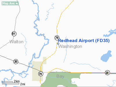
Location
& QuickFacts
|
FAA Information Effective: |
2007-01-18 |
|
Airport
Identifier: |
FD35 |
|
Airport
Status: |
Operational |
|
Longitude/Latitude: |
085-50-21.7600W/30-29-25.7020N
-85.839378/30.490473 (Estimated) |
|
Elevation: |
102 ft / 31.09 m (Estimated) |
|
Land: |
55000 acres |
|
From
nearest city: |
4 nautical miles NE of Ebro, FL |
|
Location: |
Washington County, FL |
|
Magnetic Variation: |
00W (1985) |
Owner
& Manager
|
Ownership: |
Privately owned |
|
Owner: |
Forest & Lakes |
|
Address: |
Star Rt Box 135 B
Vernon, FL 32462 |
|
Phone
number: |
904-535-2401 |
|
Manager: |
Tommy Garrett |
|
Address: |
Star Route Box 135 B
Ebro, FL 32437 |
|
Phone number: |
904-535-2401 |
Airport
Operations and Facilities
|
Airport Use: |
Private |
|
Wind
indicator: |
No |
|
Segmented
Circle: |
No |
|
Control
Tower: |
No |
|
Landing
fee charge: |
No |
|
Sectional
chart: |
New Orleans |
|
Region: |
ASO - Southern |
|
Boundary
ARTCC: |
ZJX - Jacksonville |
|
Tie-in
FSS: |
GNV - Gainesville |
|
FSS
on Airport: |
No |
|
FSS
Phone: |
850-377-3291 |
|
FSS
Toll Free: |
1-800-WX-BRIEF |
|
Runway Information
Runway 18/36
|
Dimension: |
4200 x 175 ft / 1280.2 x 53.3 m |
|
Surface: |
TURF, |
|
|
Runway 18 |
Runway 36 |
|
Traffic
Pattern: |
Left |
Left |
|
Radio Navigation
Aids
|
ID |
Type |
Name |
Ch |
Freq |
Var |
Dist |
|
BKK |
NDB |
Tri County |
|
275.00 |
02W |
25.0 nm |
|
DTS |
NDB |
Destin |
|
254.00 |
01W |
33.3 nm |
|
SMY |
NDB |
Soyya |
|
329.00 |
02W |
39.2 nm |
|
OZ |
NDB |
Ruckr |
|
212.00 |
00E |
44.2 nm |
|
PAM |
TACAN |
Tyndall |
124X |
|
00W |
28.6 nm |
|
DWG |
TACAN |
Warrington |
002X |
|
00E |
35.3 nm |
|
HRT |
TACAN |
Hurlburt |
045X |
|
00E |
44.2 nm |
|
FYL |
VOR |
Tri County |
|
108.40 |
08W |
24.3 nm |
|
EDN |
VOR |
Enterprise |
|
116.60 |
03W |
48.5 nm |
|
OZR |
VOR/DME |
Cairns |
049X |
111.20 |
02E |
47.2 nm |
|
PFN |
VORTAC |
Panama City |
090X |
114.30 |
00W |
18.4 nm |
|
MAI |
VORTAC |
Marianna |
087X |
114.00 |
00E |
41.0 nm |
|
CEW |
VORTAC |
Crestview |
106X |
115.90 |
03E |
47.9 nm |
Remarks
- 100'
FIRE TOWER 500' WEST OF ARPT.
- FARMING
EQUIPMENT MAY BE ON FIELD.
- VFR,
PVT USE ONLY.
Redhead Airport
Address:
Washington County, FL
Tel:
904-535-2401
Images
and information placed above are from
http://www.airport-data.com/airport/FD35/
We
thank them for the data!
| General
Info |
| Country |
United
States |
| State |
FLORIDA
|
| FAA ID |
FD35
|
| Latitude |
30-29-25.702N
|
| Longitude |
085-50-21.760W
|
| Elevation |
102 feet
|
| Near City |
EBRO
|
We don't guarantee the information is fresh and accurate. The data may
be wrong or outdated.
For more up-to-date information please refer to other sources.
|
|


