|
|
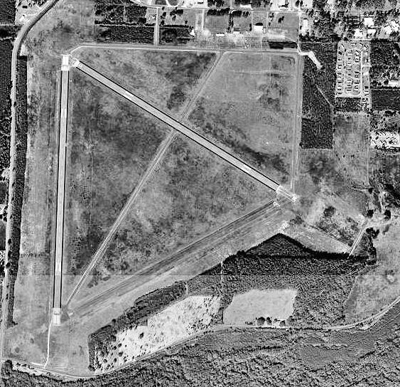
| Perry-Foley Airport |
 |
| 16 January 1999 |
| IATA: FPY – ICAO: none – FAA LID: 40J |
| Summary |
| Airport type |
Public use |
| Owner |
Taylor County, Florida |
| Operator |
Barbara Bratcher |
| Serves |
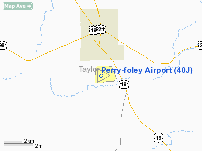
Perry, Florida |
| Location |
Taylor County, Florida |
| Elevation AMSL |
45 ft / 14 m |
| Website |
Taylor County Development Authority |
| Runways |
| Direction |
Length |
Surface |
| ft |
m |
| 6/24 |
4,378 |
1,334 |
Asphalt |
| 12/30 |
4,754 |
1,449 |
Asphalt |
| 18/36 |
4,986 |
1,520 |
Asphalt |
| Statistics (1999) |
| Aircraft operations |
18,400 |
| Based aircraft |
5 |
| Source: Federal Aviation Administration |
Coordinates: 30°04′09.40″N 083°34′50.10″W / 30.069278°N 83.580583°W / 30.069278; -83.580583 Perry-Foley Airport (IATA: FPY, FAA LID: 40J) is a public-use airport located 3 miles (4.8 km) south of the central business district of the city of Perry in Taylor County, Florida, United States. The airport is publicly owned. History
During World War II the airfield was used by the United States Army Air Forces' Third Air Force for training.
Developed on 862 acres, Perry Army Airfield became operational on 9 June 1943 as a sub-base to Dale Mabry Field in Tallahassee, Florida under the authority of the 338th Fighter Group of the 3rd Air Force.
Used as a replacement training unit; pilots at Perry received their final training in P-40 Warhawks, P-47 Thunderbolts, and P-51 Mustangs at Perry AAF prior to joining operational units in the European or Pacific theaters with the 312th and 441st Fighter Squadrons.
With the close of hostilities, the last military pilots left Perry AAF in September 1945. Deeded to Taylor County by the War Assets Administration in April 1947, the field reverted to civilian aviation purposes and has been used as a general aviation airfield ever since.
The above content comes from Wikipedia and is published under free licenses – click here to read more.
Location
& QuickFacts
|
FAA Information Effective: |
2007-01-18 |
|
Airport
Identifier: |
40J |
|
Airport
Status: |
Operational |
|
Longitude/Latitude: |
083-34-50.1000W/30-04-09.4000N
-83.580583/30.069278 (Estimated) |
|
Elevation: |
45 ft / 13.72 m (Surveyed) |
|
Land: |
927 acres |
|
From
nearest city: |
3 nautical miles S of Perry, FL |
|
Location: |
Taylor County, FL |
|
Magnetic Variation: |
03W (2000) |
Owner
& Manager
|
Ownership: |
Publicly owned |
|
Owner: |
Taylor County |
|
Address: |
201 East Green Street
Perry, FL 32347 |
|
Phone
number: |
850-838-3500 |
|
Manager: |
Barbara Bratcher |
|
Address: |
201 East Green Street
Perry, FL 32347 |
|
Phone
number: |
850-838-3500
NO PHONE CURRENTLY AVBL AT ARPT. |
Airport
Operations and Facilities
|
Airport Use: |
Open to public |
|
Wind
indicator: |
Yes |
|
Segmented
Circle: |
No |
|
Control
Tower: |
No |
|
Lighting
Schedule: |
DUSK-DAWN
ACTVT MIRL RYS 12/30 & 18/36 AND REIL RYS 12, 30, 18
& 36 - CTAF.
PAPI RYS 12, 30, 18 & 36 OPER CONT. |
|
Beacon
Color: |
Clear-Green (lighted land airport) |
|
Landing
fee charge: |
No |
|
Sectional
chart: |
Jacksonville |
|
Region: |
ASO - Southern |
|
Boundary
ARTCC: |
ZJX - Jacksonville |
|
Tie-in
FSS: |
GNV - Gainesville |
|
FSS
on Airport: |
No |
|
FSS
Phone: |
850-377-3291 |
|
FSS
Toll Free: |
1-800-WX-BRIEF |
|
NOTAMs
Facility: |
GNV (NOTAM-d service avaliable) |
|
Federal Agreements: |
NGPRY |
Airport
Communications
|
CTAF: |
122.800 |
|
Unicom: |
122.800 |
Airport
Services
|
Fuel available: |
100LLA
FUEL SELF SVC WITH CREDIT CARD. |
|
Bottled
Oxygen: |
NONE |
|
Bulk
Oxygen: |
NONE |
|
Runway Information
Runway 06/24
|
Dimension: |
4378 x 150 ft / 1334.4 x 45.7 m |
|
Surface: |
ASPH, Fair Condition |
|
Weight
Limit: |
Single wheel: 30000 lbs. |
|
|
Runway 06 |
Runway 24 |
|
Longitude: |
083-35-04.0880W |
083-34-20.8276W |
|
Latitude: |
30-03-46.6050N |
30-04-08.0985N |
|
Elevation: |
42.00 ft |
44.00 ft |
|
Alignment: |
60 |
127 |
|
Traffic
Pattern: |
Left |
Left |
|
Markings: |
Basic, Fair Condition
/24 MARKINGS FADED. |
Basic, Fair Condition |
|
Obstruction: |
40 ft trees, 1560.0 ft from runway, 34:1 slope
to clear |
25 ft trees, 1200.0 ft from runway, 40:1 slope
to clear |
|
Runway 12/30
|
Dimension: |
4754 x 150 ft / 1449.0 x 45.7 m |
|
Surface: |
ASPH, Good Condition |
|
Weight
Limit: |
Single wheel: 30000 lbs. |
|
Edge
Lights: |
Medium |
|
|
Runway 12 |
Runway 30 |
|
Longitude: |
083-35-03.4105W |
083-34-16.7998W |
|
Latitude: |
30-04-32.5161N |
30-04-08.6151N |
|
Elevation: |
43.00 ft |
44.00 ft |
|
Alignment: |
121 |
127 |
|
Traffic
Pattern: |
Left |
Left |
|
Markings: |
Basic, Good Condition |
Basic, Good Condition |
|
VASI: |
2-light PAPI on left side |
2-light PAPI on left side |
|
Visual
Glide Angle: |
4.00� |
4.00� |
|
Runway
End Identifier: |
Yes |
Yes |
|
Obstruction: |
44 ft trees, 1300.0 ft from runway, 150 ft
right of centerline, 25:1 slope to clear |
38 ft trees, 1500.0 ft from runway, 34:1 slope
to clear |
|
Runway 18/36
|
Dimension: |
4986 x 100 ft / 1519.7 x 30.5 m |
|
Surface: |
ASPH, Good Condition |
|
Weight
Limit: |
Single wheel: 30000 lbs. |
|
Edge
Lights: |
Medium |
|
|
Runway 18 |
Runway 36 |
|
Longitude: |
083-35-05.9436W |
083-35-06.6944W |
|
Latitude: |
30-04-34.1154N |
30-03-44.7674N |
|
Elevation: |
43.00 ft |
41.00 ft |
|
Alignment: |
127 |
1 |
|
Traffic
Pattern: |
Left |
Left |
|
Markings: |
Non-precision instrument, Fair Condition |
Non-precision instrument, Fair Condition |
|
VASI: |
2-light PAPI on left side |
2-light PAPI on left side |
|
Visual
Glide Angle: |
4.00� |
4.00� |
|
Runway
End Identifier: |
Yes |
Yes
REIL OTS INDEFLY. |
|
Centerline
Lights: |
No |
|
|
Obstruction: |
28 ft trees, 900.0 ft from runway, 300 ft left
of centerline, 25:1 slope to clear |
35 ft trees, 1050.0 ft from runway, 24:1 slope
to clear |
|
Radio Navigation
Aids
|
ID |
Type |
Name |
Ch |
Freq |
Var |
Dist |
|
FPY |
NDB |
Foley |
|
254.00 |
03W |
4.4 nm |
|
TL |
NDB |
Wakul |
|
379.00 |
01W |
43.3 nm |
|
OTK |
VOR/DME |
Valdosta |
095X |
114.80 |
02W |
45.5 nm |
|
GEF |
VORTAC |
Greenville |
027X |
109.00 |
01E |
30.8 nm |
|
CTY |
VORTAC |
Cross City |
057X |
112.00 |
02W |
39.6 nm |
|
TLH |
VOT |
Tallahassee Muni |
|
111.00 |
|
44.9 nm |
Remarks
- 300'
CONC STWY RYS 06 & 12 & 24.
- EXISTED
PRIOR TO 1948.
Based Aircraft
|
Aircraft
based on field: |
5 |
|
Single
Engine Airplanes: |
4 |
|
Multi
Engine Airplanes: |
1 |
Operational Statistics
Time Period: 1998-05-11
- 1999-05-10
|
Aircraft
Operations: |
51/Day |
|
Air Taxi: |
1.1% |
|
General
Aviation Local: |
59.8% |
|
General
Aviation Itinerant: |
38.0% |
|
Military: |
1.1% |
Perry-foley Airport
Address:
Taylor County, FL
Tel:
850-838-3500
Images
and information placed above are from
http://www.airport-data.com/airport/40J/
We
thank them for the data!
| General
Info |
| Country |
United
States |
| State |
FLORIDA
|
| FAA ID |
40J
|
| Latitude |
30-04-09.400N
|
| Longitude |
083-34-50.100W
|
| Elevation |
45 feet
|
| Near City |
PERRY
|
We don't guarantee the information is fresh and accurate. The data may
be wrong or outdated.
For more up-to-date information please refer to other sources.
|
|