|
|
Pensacola Regional Airport |
| Pensacola Gulf Coast Regional Airport |
| IATA: PNS – ICAO: KPNS – FAA LID: PNS
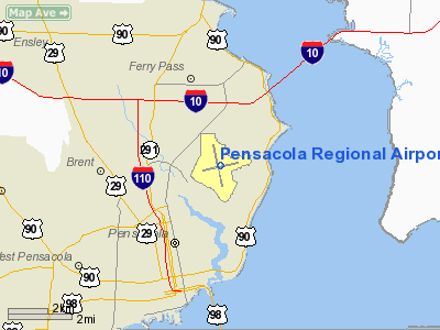
Location of the Pensacola Gulf Coast Regional Airport
|
| Summary |
| Airport type |
Public |
| Owner |
City of Pensacola |
| Serves |
Pensacola, Florida |
| Elevation AMSL |
121 ft / 37 m |
| Coordinates |
30°28′24″N 087°11′12″W / 30.47333°N 87.18667°W / 30.47333; -87.18667 |
| Website |
www.flypensacola.com |
| Runways |
| Direction |
Length |
Surface |
| ft |
m |
| 8/26 |
7,000 |
2,134 |
Asphalt |
| 17/35 |
7,004 |
2,135 |
Asphalt |
| Statistics (2008) |
| Aircraft operations |
101,498 |
| Based aircraft |
81 |
| Source: Federal Aviation Administration |
Pensacola Gulf Coast Regional Airport (IATA: PNS, ICAO: KPNS, FAA LID: PNS) is a public airport located 3 miles (5 km) northeast of the city of Pensacola in Escambia County, Florida. Facilities
Pensacola Gulf Coast Regional Airport covers 1,211 acres (490 ha) and has two runways:
- Runway 17/35: 7,004 x 150 ft. (2,135 x 46 m), Surface: Asphalt
- Runway 8/26: 7,000 x 150 ft. (2,133 x 46 m), Surface: Asphalt
The Runway 17 approach is equipped with a full instrument landing system and approach light system, while the Runway 26 approach is equipped with a localizer approach. A 1,000 ft. extension to the east end of Runway 8/26 was completed in 2006. The airport hopes to extend Runway 17/35 to about 8,500 ft. in the future, to better accommodate heavy aircraft.
Runway 17/35 was originally designated 16/34, and Runway 8/26 was designated 7/25. A gradual shift in magnetic north necessitated their re-designation during the 1980s. The airport's two war-era diagonal runways were decommissioned in the 1960s.
Terminal
Pensacola has one passenger terminal consisting of 12 gates. Gates 9-12 are on the lower level and used for commuter flights.
Gate Assignments:
AirTran: Gate 6
American: Gate 5
Continental: Gates 3 and 11
Delta: Gates 2, 4, and 8
United: Gate 1
US Airways: Gate 7
Terminal Expansion
Airlines and destinations
The following airlines fly these non-stop flights to Pensacola Gulf Coast Regional Airport:
| Airlines |
Destinations |
| AirTran Airways |
Atlanta |
| American Eagle |
Chicago-O'Hare, Dallas/Fort Worth, Miami |
| Continental Connection operated by Gulfstream International Airlines |
Orlando, Tampa |
| Continental Express operated by ExpressJet Airlines |
Houston-Intercontinental |
| Delta Air Lines |
Atlanta |
| Delta Connection operated by Atlantic Southeast Airlines |
Atlanta |
| Delta Connection operated by Pinnacle Airlines |
Memphis |
| United Express operated by Atlantic Southeast Airlines |
Chicago-O'Hare, Washington-Dulles |
| United Express operated by ExpressJet Airlines |
Chicago-O'Hare |
| US Airways Express operated by Mesa Airlines |
Charlotte |
| US Airways Express operated by PSA Airlines |
Charlotte |
| US Airways Express operated by Republic Airlines |
Charlotte [resumes November 1] |
Incidents
On May 8, 1978 National Airlines Flight 193 landed in Escambia Bay while approaching the east-west runway, due primarily but not entirely to pilot error.
On December 27, 1987, at 11:39pm Eastern Airlines DC-9-31 N8948E made a hard landing and split its fuselage open just aft of its wing root.
On July 6, 1996, Delta Air Lines flight 1288, an MD-88, experienced an uncontained engine failure during takeoff on Runway 17. Fragments from the number one (left) Pratt & Whitney JT8D-219 turbofan engine penetrated the fuselage, killing two and seriously injuring one of the 148 people onboard.
The above content comes from Wikipedia and is published under free licenses – click here to read more.
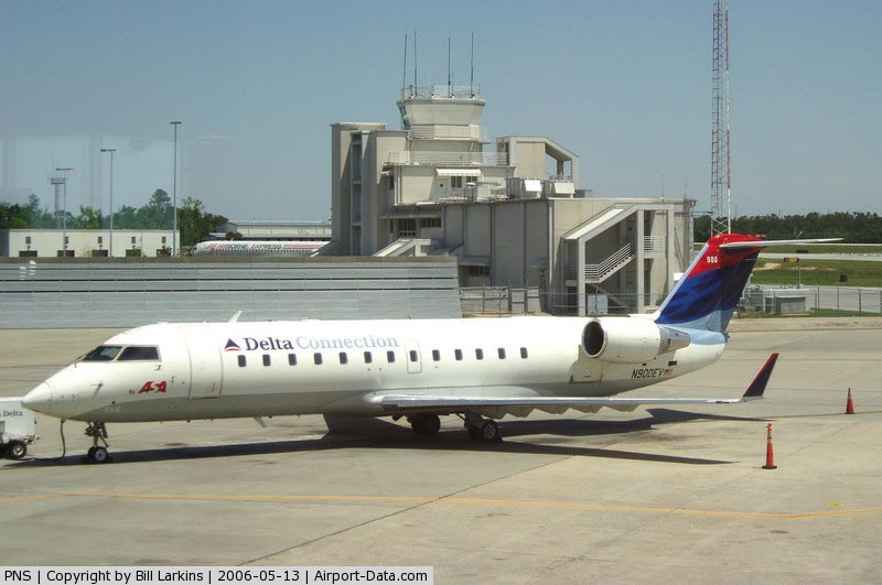
|
 |
(Click on the photo to enlarge) |
|
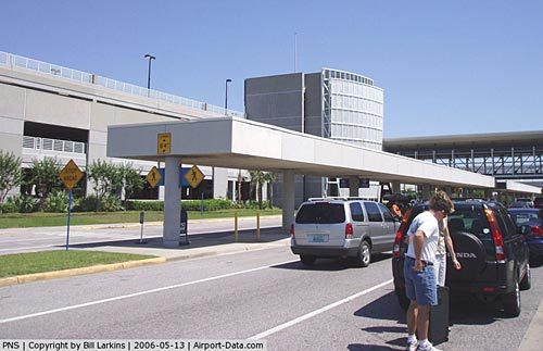 |
(Click on the photo to enlarge) |
Location
& QuickFacts
|
FAA Information Effective: |
2007-01-18 |
|
Airport
Identifier: |
PNS |
|
Airport
Status: |
Operational |
|
Longitude/Latitude: |
087-11-11.8040W/30-28-24.3320N
-87.186612/30.473426 (Estimated) |
|
Elevation: |
121 ft / 36.88 m (Surveyed) |
|
Land: |
1211 acres |
|
From
nearest city: |
3 nautical miles NE of Pensacola, FL |
|
Location: |
Escambia County, FL |
|
Magnetic Variation: |
01E (1985) |
Owner
& Manager
|
Ownership: |
Publicly owned |
|
Owner: |
City Of Pensacola |
|
Address: |
2430 Airport Blvd Suite 225
Pensacola, FL 32504 |
|
Phone
number: |
850-436-5000 |
|
Manager: |
Frank Miller |
|
Address: |
2430 Airport Blvd Suite 225
Pensacola, FL 32504 |
|
Phone number: |
850-436-5000 |
Airport
Operations and Facilities
|
Airport Use: |
Open to public |
|
Wind
indicator: |
Yes |
|
Segmented
Circle: |
Yes |
|
Control
Tower: |
Yes |
|
Lighting
Schedule: |
DUSK-DAWN
WHEN ATCT CLSD, ACTIVATE HIRL RY 17/35 & HIRL RY 08/26,
MALSR RY 17 - CTAF. |
|
Beacon
Color: |
Clear-Green (lighted land airport) |
|
Landing
fee charge: |
No |
|
Sectional
chart: |
New Orleans |
|
Region: |
ASO - Southern |
|
Traffic
Pattern Alt: |
1000 ft |
|
Boundary
ARTCC: |
ZJX - Jacksonville |
|
Tie-in
FSS: |
GNV - Gainesville |
|
FSS
on Airport: |
No |
|
FSS
Phone: |
850-377-3291 |
|
FSS
Toll Free: |
1-800-WX-BRIEF |
|
NOTAMs
Facility: |
PNS (NOTAM-d service avaliable) |
|
Certification
type/date: |
I C S 04/2005
PPR 24 HRS FOR UNSKED ACR OPNS WITH MORE THAN 30 PSGR SEATS
OR FOR UNSKED ACFT GREATER THAN 65,000 GWT CALL ARPT OPNS
850-436-5000. |
|
Federal Agreements: |
NGRY3 |
Airport
Communications
|
CTAF: |
119.900 |
|
Unicom: |
122.950 |
Airport
Services
|
Fuel available: |
100 100LLA |
|
Airframe Repair: |
MAJOR |
|
Power Plant Repair: |
MAJOR |
|
Bottled
Oxygen: |
NONE |
|
Bulk
Oxygen: |
HIGH |
|
Runway Information
Runway 08/26
|
Dimension: |
7000 x 150 ft / 2133.6 x 45.7 m |
|
Surface: |
ASPH, |
|
Surface
Treatment: |
Saw-cut or plastic Grooved |
|
Weight
Limit: |
Single wheel: 85000 lbs.
Dual wheel: 150000 lbs.
Dual
tandem wheel: 270000 lbs. |
|
Edge
Lights: |
High |
|
|
Runway 08 |
Runway 26 |
|
Longitude: |
087-11-45.3800W |
087-10-27.1130W |
|
Latitude: |
30-28-16.8010N |
30-28-31.1280N |
|
Elevation: |
97.00 ft |
114.00 ft |
|
Alignment: |
78 |
127 |
|
ILS
Type: |
|
LOC/DME |
|
Traffic
Pattern: |
Left |
Left |
|
Markings: |
Non-precision instrument, Good Condition |
Non-precision instrument, Good Condition |
|
Crossing
Height: |
50.00 ft |
50.00 ft |
|
VASI: |
4-light PAPI on left side |
4-light PAPI on left side |
|
Visual
Glide Angle: |
3.00� |
3.00� |
|
Runway
End Identifier: |
Yes |
Yes |
|
Obstruction: |
60 ft pole, 1200.0 ft from runway, 375 ft right
of centerline, 16:1 slope to clear |
, 50:1 slope to clear |
|
Runway 17/35
|
Dimension: |
7004 x 150 ft / 2134.8 x 45.7 m |
|
Surface: |
ASPH, Fair Condition |
|
Surface
Treatment: |
Saw-cut or plastic Grooved |
|
Weight
Limit: |
Single wheel: 85000 lbs.
Dual wheel: 150000 lbs.
Dual
tandem wheel: 270000 lbs. |
|
Edge
Lights: |
High |
|
|
Runway 17 |
Runway 35 |
|
Longitude: |
087-11-26.3725W |
087-11-08.3496W |
|
Latitude: |
30-28-58.4711N |
30-27-50.9282N |
|
Elevation: |
121.00 ft |
103.00 ft |
|
Alignment: |
127 |
127 |
|
ILS
Type: |
ILS/DME |
|
|
Traffic
Pattern: |
Left |
Left |
|
Markings: |
Precision instrument, Fair Condition |
Precision instrument, Good Condition |
|
Crossing
Height: |
0.00
ft |
46.00 ft |
|
VASI: |
|
4-box on left side |
|
Visual
Glide Angle: |
0.00� |
3.00� |
|
RVR
Equipment: |
touchdown |
touchdown |
|
Approach
lights: |
MALSR |
|
|
Runway
End Identifier: |
|
Yes |
|
Centerline
Lights: |
Yes |
Yes |
|
Touchdown
Lights: |
Yes |
Yes |
|
Obstruction: |
86 ft pline, 4390.0 ft from runway, 500 ft
left of centerline, 48:1 slope to clear |
, 50:1 slope to clear |
|
Radio Navigation
Aids
|
ID |
Type |
Name |
Ch |
Freq |
Var |
Dist |
|
PKZ |
NDB |
Pickens |
|
326.00 |
01E |
2.2 nm |
|
ESU |
NDB |
Summerdale |
|
204.00 |
01E |
28.0 nm |
|
DTS |
NDB |
Destin |
|
254.00 |
01W |
37.2 nm |
|
NPA |
TACAN |
Pensacola |
119X |
|
01E |
9.7 nm |
|
NGS |
TACAN |
Santa Rosa |
063X |
|
01E |
15.4 nm |
|
NSE |
TACAN |
Whiting |
070X |
|
01E |
17.4 nm |
|
HRT |
TACAN |
Hurlburt |
045X |
|
00E |
25.9 nm |
|
DWG |
TACAN |
Warrington |
002X |
|
00E |
34.5 nm |
|
NUN |
VOR |
Saufley |
|
108.80 |
01E |
7.7 nm |
|
CEW |
VORTAC |
Crestview |
106X |
115.90 |
03E |
33.7 nm |
|
BFM |
VORTAC |
Brookley |
075X |
112.80 |
04E |
45.8 nm |
Remarks
- LARGE
NUMBERS OF BIRDS ON & INVOF ARPT.
- TWY
C SOUTH OF 8/26, C1, C2, TWY D EAST OF 17/35, D1, D2, D3, D4, AND D5
ARE ONLY 35 FT WIDE AND ARE CLSD TO ACFT WITH A WINGSPAN LARGER THAN
79 FT.
- RY
08 HAS 5 FT RADAR REFLECTOR 1651 FT FROM THR.
- TURBOJET
POWERED AIRPLANES WITH A MAXIMUM CERTIFIED TAKE OFF WEIGHT OVER 75000
LBS SHOULD EXECUTE THE STANDARD NOISE ABATEMENT DEPARTURE PROFILE FOR
ALL DEPARTURES IN ACCORDANCE WITH FAA AC 91-53.
- FIXED
WING VFR DEPS PROCEED TO ARPT BOUNDARY BEFORE TURNING UNLESS OTHERWISE
DIRECTED BY ATC.
- RY
08 IS PREFERRED DEP RY.
- HELICOPTER
LNDG CTC HELIWORKS 850-438-6056. HELICOPTER PARKING IS LOCATED NW OF
AIR CARRIER RAMP ON THE ASPH RAMP.
Based Aircraft
|
Aircraft
based on field: |
85 |
|
Single
Engine Airplanes: |
45 |
|
Multi
Engine Airplanes: |
29 |
|
Jet Engine
Airplanes: |
7 |
|
Helicopters: |
4 |
Major Carriers
Serving This Airport
| American Eagle Airlines Inc. |
26.9% |
| Delta Air Lines Inc. |
22.8% |
| Expressjet Airlines Inc. |
18.3% |
| AirTran Airways Corporation |
16.8% |
| Mesa Airlines Inc. |
6.8% |
| Comair Inc. |
5.9% |
| Atlantic Southeast Airlines |
2.5% |
Most Popular Destinations
|
Hartsfield - Jackson Atlanta Intl (ATL) |
42.1% |
|
Dallas/fort Worth Intl (DFW) |
23.6% |
|
George Bush Intercontinental/houston (IAH) |
18.3% |
| Charlotte/douglas Intl (CLT) |
6.8% |
| Chicago O'hare Intl (ORD) |
3.4% |
|
Cincinnati/northern Kentucky Intl (CVG) |
3.3% |
| Jacksonville Intl (JAX) |
2.6% |
Most Popular Aircraft
|
N831AE |
1.2% |
| N821AE |
1.0% |
|
N801AE |
0.9% |
| N857AE |
0.9% |
|
N805AE |
0.8% |
| N813AE |
0.7% |
|
N848AE |
0.6% |
| N843AE |
0.6% |
|
N841AE |
0.6% |
| N807AE |
0.6% |
Operational Statistics
Time Period: 2004-12-31
- 2005-12-30
|
Aircraft
Operations: |
354/Day |
|
Commerical: |
8.1% |
|
Air Taxi: |
22.5% |
|
General
Aviation Local: |
24.9% |
|
General
Aviation Itinerant: |
23.8% |
|
Military: |
20.7% |
Pensacola Regional Airport
Address:
Escambia County, FL
Tel:
850-436-5000
Images
and information placed above are from
http://www.airport-data.com/airport/PNS/
We
thank them for the data!
| General
Info |
| Country |
United
States |
| State |
FLORIDA
|
| FAA ID |
PNS
|
| Latitude |
30-28-23.900N
|
| Longitude |
087-11-14.800W
|
| Elevation |
121 feet
|
| Near City |
PENSACOLA
|
We don't guarantee the information is fresh and accurate. The data may
be wrong or outdated.
For more up-to-date information please refer to other sources.
|
|