 |
|
| Orlando Apopka Airport |
 |
| IATA: none – ICAO: none – FAA LID: X04 |
| Summary |
| Airport type |
Public use |
| Owner/Operator |
Orlando Apopka Airport Owners Association |
| Serves |
Orlando, Florida |
| Location |
Apopka, Florida |
| Elevation AMSL |
143 ft / 44 m |
| Coordinates |
28°42′26″N 081°34′54″W / 28.70722°N 81.58167°W / 28.70722; -81.58167 |
| Website |
www.orlX04.org |
| Runways |
| Direction |
Length |
Surface |
| ft |
m |
| 15/33 |
3,250 |
991 |
Asphalt |
| Statistics (2009) |
| Aircraft operations |
21,900 |
| Based aircraft |
43 |
| Source: Federal Aviation Administration |
Orlando Apopka Airport (FAA LID: X04) is a privately-owned, public-use airport located four nautical miles (7 km) northwest of the central business district of Apopka, in Orange County, Florida, United States. It was formerly known as Orlando Country Airport.
Facilities and aircraft
Orlando Apopka Airport covers an area of 80 acres (32 ha) at an elevation of 143 feet (44 m) above mean sea level. It has one asphalt paved runway designated 15/33 which measures 3,250 by 60 feet (991 x 18 m).
The common areas of the airport are maintained by the OAA Owners Association, but the hangers and lots are individually owned.
For the 12-month period ending January 16, 2009, the airport had 21,900 general aviation aircraft operations, an average of 60 per day. At that time there were 43 aircraft based at this airport: 84% single-engine and 16% multi-engine.
The above content comes from Wikipedia and is published under free licenses – click here to read more.
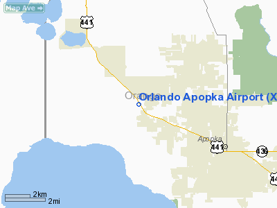
Location
& QuickFacts
|
FAA Information Effective: |
2007-01-18 |
|
Airport
Identifier: |
X04 |
|
Airport
Status: |
Operational |
|
Longitude/Latitude: |
081-34-54.2640W/28-42-25.9840N
-81.581740/28.707218 (Estimated) |
|
Elevation: |
143 ft / 43.59 m (Estimated) |
|
Land: |
80 acres |
|
From
nearest city: |
4 nautical miles NW of Apopka, FL |
|
Location: |
Orange County, FL |
|
Magnetic Variation: |
03W (1985) |
Owner
& Manager
|
Ownership: |
Privately owned |
|
Owner: |
Orlando County Aviation Services |
|
Address: |
4040 W. Hwy 441
Apopka, FL 32712 |
|
Phone number: |
407-886-7663 |
|
Manager: |
Ron Henderson |
|
Address: |
4040 W. Hwy 441
Apopka, FL 32712 |
|
Phone number: |
407-886-7663 |
Airport
Operations and Facilities
|
Airport Use: |
Open to public |
|
Wind
indicator: |
Yes |
|
Segmented
Circle: |
Yes
NON-STANDARD SEGMENTED CIRCLE PAINTED ON HANGAR ROOF. |
|
Control
Tower: |
No |
|
Lighting
Schedule: |
DUSK-DAWN |
|
Beacon
Color: |
Clear-Green (lighted land airport)
ARPT BCN OTS INDEFLY. |
|
Landing
fee charge: |
No |
|
Sectional
chart: |
Jacksonville |
|
Region: |
ASO - Southern |
|
Traffic
Pattern Alt: |
800 ft |
|
Boundary
ARTCC: |
ZJX - Jacksonville |
|
Tie-in
FSS: |
PIE - Saint Petersburg |
|
FSS
on Airport: |
No |
|
FSS
Toll Free: |
1-800-WX-BRIEF |
|
NOTAMs
Facility: |
PIE (NOTAM-d service avaliable) |
Airport
Communications
|
CTAF: |
123.050 |
|
Unicom: |
123.050 |
Airport
Services
|
Fuel available: |
100LLMOGAS |
|
Airframe Repair: |
MAJOR |
|
Power Plant Repair: |
MAJOR |
|
Bottled
Oxygen: |
NONE |
|
Bulk
Oxygen: |
NONE |
|
Runway Information
Runway 15/33
|
Dimension: |
3165 x 100 ft / 964.7 x 30.5 m |
|
Surface: |
ASPH-TURF, Fair Condition
RY 15/33 CENTER 30 FT OF RY WIDTH ASPH WITH 35 FT TURF EITHER SIDE
OF PAVED SFC. |
|
Edge
Lights: |
Low
LIRL LOCATED 60 FT FM CNTRLN OF RY. |
|
|
Runway 15 |
Runway 33 |
|
Traffic
Pattern: |
Right |
Left |
|
Markings: |
Numbers only, Fair Condition |
Numbers only, Fair Condition |
|
Displaced
threshold: |
190.00 ft
RY 15 & 33 DISPLCD THLDS NOT LIGHTED. |
375.00 ft |
|
Obstruction: |
23 ft rr, 270.0 ft from runway, 135 ft left
of centerline, 3:1 slope to clear
RY 15 APCH RATIO 20:1 FM DSPLCD THR. |
24 ft trees, 200.0 ft from runway, 140 ft right
of centerline
RY 33 APCH RATIO 20:1 FROM ANT ON HGR.
20 FT BLDG 100 FT R OF CNTRLN 50 FT FROM END OF RY. |
|
Radio Navigation
Aids
|
ID |
Type |
Name |
Ch |
Freq |
Var |
Dist |
|
LEE |
NDB |
Leesburg |
|
335.00 |
04W |
13.6 nm |
|
SFB |
NDB |
Sanford |
|
408.00 |
05W |
18.4 nm |
|
ISM |
NDB |
Kissimmee |
|
329.00 |
05W |
26.3 nm |
|
DED |
NDB |
Deland/dcmsnd |
|
201.00 |
05W |
27.0 nm |
|
EVB |
NDB |
New Smyrna Beach |
|
417.00 |
04W |
39.6 nm |
|
GGL |
NDB |
Geiger Lake |
|
375.00 |
05W |
40.9 nm |
|
RHZ |
NDB |
Zephyrhills |
|
253.00 |
03W |
41.9 nm |
|
TTS |
TACAN |
Kennedy Space Center |
059Y |
|
00E |
47.0 nm |
|
ORL |
VORTAC |
Orlando |
059X |
112.20 |
00E |
16.3 nm |
|
OMN |
VORTAC |
Ormond Beach |
073X |
112.60 |
00E |
43.5 nm |
|
OCF |
VORTAC |
Ocala |
084X |
113.70 |
00E |
44.1 nm |
|
LAL |
VORTAC |
Lakeland |
107X |
116.00 |
01E |
49.0 nm |
|
DAB |
VOT |
Daytona Beach |
|
111.00 |
|
39.7 nm |
Remarks
- STEEP
DROPOFF 63' FROM SE END & APRXLY 55' OFF WEST EDGE.
- RY
15/33 RR PENETRATES 7:1 TRANS SFC EAST SIDE.
- CTC
UNICOM OR 407-886-7663 FOR SAFETY BRIEFING.
- AIRCRAFT
PARKED 80 FT EAST OF RY 15/33 CNTRLN NEAR SE END OF RY.
- RY
15/33 LIRL OTS INDEFLY.
- VFR
ONLY
Based Aircraft
|
Aircraft
based on field: |
43 |
|
Single
Engine Airplanes: |
36 |
|
Multi
Engine Airplanes: |
7 |
Operational Statistics
Time Period: 1998-10-22
- 1999-10-21
|
Aircraft
Operations: |
60/Day |
|
General
Aviation Local: |
75.3% |
|
General
Aviation Itinerant: |
24.7% |
Orlando Apopka Airport
Address:
Orange County, FL
Tel:
407-886-7663
Images
and information placed above are from
http://www.airport-data.com/airport/X04/
We
thank them for the data!
| General
Info |
| Country |
United
States |
| State |
FLORIDA
|
| FAA ID |
X04
|
| Latitude |
28-42-25.984N
|
| Longitude |
081-34-54.264W
|
| Elevation |
143 feet
|
| Near City |
PLYMOUTH
|
We don't guarantee the information is fresh and accurate. The data may
be wrong or outdated.
For more up-to-date information please refer to other sources.
|
|


