|
|
North Palm Beach County General Aviation Airport |
| North Palm Beach County General Aviation Airport |
| IATA: none – ICAO: none – FAA LID: F45 |
| Summary |
| Airport type |
Public |
| Owner |
Palm Beach County |
| Serves |
West Palm Beach, Florida |
| Location |
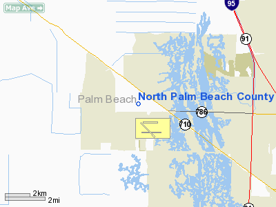
Palm Beach Gardens, Florida |
| Elevation AMSL |
22 ft / 7 m |
| Coordinates |
26°50′45″N 080°13′20″W / 26.84583°N 80.22222°W / 26.84583; -80.22222 |
| Runways |
| Direction |
Length |
Surface |
| ft |
m |
| 8L/26R |
3,700 |
1,128 |
Turf |
| 8R/26L |
4,300 |
1,311 |
Asphalt |
| 13/31 |
4,303 |
1,312 |
Asphalt |
| Statistics (2002) |
| Aircraft operations |
35,532 |
| Based aircraft |
215 |
| Source: Federal Aviation Administration |
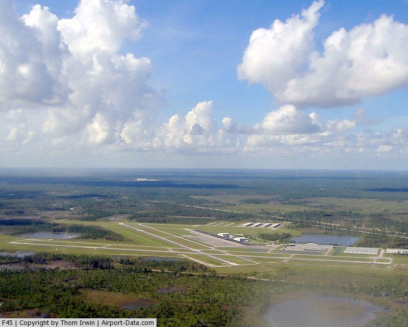
North Palm Beach County Airport (FAA LID: F45), also known as North County Airport, is an uncontrolled general aviation airport located 12 nautical miles (22 km) northwest of West Palm Beach off the Bee Line Highway in Palm Beach Gardens, Florida. The airport is owned by Palm Beach County and operated by the Palm Beach County Airports Department.
The field is in proximity to, and shares services with, William P. Gwinn Airport (FAA LID: 06FA) (more commonly referred to as Gwinn Airfield) which is owned by United Technologies Corporation (UTC). It was previously operated by its Pratt & Whitney jet engine business unit and is currently operated by its Sikorsky Aircraft business unit. Due to its proximity to the Sikorsky test grounds, North County is often used to test ILS approaches on experimental or prototype helicopters such as the RAH-66 Comanche, SH-60 Seahawk and the S-92.
DayJet previously provided an on-demand jet air taxi service from this airport to Jacksonville, Lakeland, Tallahassee, Pensacola, Gainesville, Boca Raton, Opa-Locka/Miami Dade County, Naples, Sarasota/Bradenton, Savannah, Macon, and Montgomery until its liquidation in bankruptcy in 2008.
Facilities and aircraft
North Palm Beach County General Aviation Airport covers an area of 1,832 acres (741 ha) at an elevation of 22 feet (7 m) above mean sea level. It has one turf runway designated 8L/26R which measuring 3,700 by 75 feet (1,128 x 23 m), plus two asphalt paved runways: 8R/26L measuring 4,300 by 100 feet (1,311 x 30 m) and 13/31 measuring 4,303 by 75 feet (1,312 x 23 m).
For the 12-month period ending June 20, 2002, the airport had 35,532 aircraft operations, an average of 97 per day, all of which were general aviation. At that time there were 215 aircraft based at this airport: 60% single-engine, 31% multi-engine, 3% jet, 4% glider and 2% helicopter.
There are two active helicopter landing pads.
The airport has one fixed base operator, Landmark Aviation.
North County is home to Ocean Helicopters and Cloud 9 Helicopters Both maintain a fleet of Robinson helicopters and both are FAA Certified Part 141 Flight Schools. There are also 2 fixed wing schools, Sunquest Aviation and Aeronautix.
The above content comes from Wikipedia and is published under free licenses – click here to read more.
|
 |
(Click on the photo to enlarge) |
|
 |
(Click on the photo to enlarge) |
Location
& QuickFacts
|
FAA Information Effective: |
2007-01-18 |
|
Airport
Identifier: |
F45 |
|
Airport
Status: |
Operational |
|
Longitude/Latitude: |
080-13-20.5000W/26-50-45.3000N
-80.222361/26.845917 (Estimated) |
|
Elevation: |
22 ft / 6.71 m (Surveyed) |
|
Land: |
1832 acres |
|
From
nearest city: |
12 nautical miles NW of West Palm Beach,
FL |
|
Location: |
Palm Beach County, FL |
|
Magnetic Variation: |
04W (1995) |
Owner
& Manager
|
Ownership: |
Publicly owned |
|
Owner: |
Palm Beach County |
|
Address: |
Palm Beach Intl Arpt
West Palm Beach, FL 33406 |
|
Phone
number: |
561-471-7400 |
|
Manager: |
Bruce V Pelly |
|
Address: |
Palm Beach Intl Arpt
West Palm Beach, FL 33406 |
|
Phone number: |
561-471-7400 |
Airport
Operations and Facilities
|
Airport Use: |
Open to public |
|
Wind
indicator: |
Yes |
|
Segmented
Circle: |
Yes |
|
Control
Tower: |
No |
|
Lighting
Schedule: |
DUSK-DAWN |
|
Beacon
Color: |
Clear-Green (lighted land airport) |
|
Sectional
chart: |
Miami |
|
Region: |
ASO - Southern |
|
Boundary
ARTCC: |
ZMA - Miami |
|
Tie-in
FSS: |
MIA - Miami |
|
FSS
on Airport: |
No |
|
FSS
Phone: |
305-233-2600 |
|
FSS
Toll Free: |
1-800-WX-BRIEF |
|
NOTAMs
Facility: |
MIA (NOTAM-d service avaliable) |
|
Federal Agreements: |
N |
Airport
Communications
|
CTAF: |
123.075 |
|
Unicom: |
123.075 |
Airport
Services
|
Fuel available: |
100LLA |
|
Airframe Repair: |
MAJOR |
|
Power Plant Repair: |
MAJOR |
|
Runway Information
Runway 08L/26R
|
Dimension: |
3700 x 75 ft / 1127.8 x 22.9 m |
|
Surface: |
TURF, Fair Condition |
|
|
Runway 08L |
Runway 26R |
|
Longitude: |
080-13-49.2957W |
080-13-08.5830W |
|
Latitude: |
26-50-56.9806N |
26-50-59.9612N |
|
Elevation: |
20.00
ft |
21.00
ft |
|
Alignment: |
85 |
127 |
|
Traffic
Pattern: |
Left |
Right |
|
Obstruction: |
, 50:1 slope to clear |
50 ft pline, 1000.0 ft from runway, 20:1 slope
to clear |
|
Runway 08R/26L
|
Dimension: |
4300 x 100 ft / 1310.6 x 30.5 m |
|
Surface: |
ASPH, Good Condition |
|
Edge
Lights: |
High |
|
|
Runway 08R |
Runway 26L |
|
Longitude: |
080-13-36.6993W |
080-12-49.3886W |
|
Latitude: |
26-50-33.0929N |
26-50-36.5427N |
|
Elevation: |
21.00
ft |
21.00
ft |
|
Alignment: |
85 |
127 |
|
ILS
Type: |
ILS/DME |
|
|
Traffic
Pattern: |
Right |
Left |
|
Markings: |
Non-precision instrument, Good Condition |
Non-precision instrument, Good Condition |
|
Crossing
Height: |
40.00 ft |
40.00 ft |
|
VASI: |
2-light PAPI on left side |
2-light PAPI on left side |
|
Visual
Glide Angle: |
3.00� |
3.00� |
|
Runway
End Identifier: |
Yes |
Yes |
|
Obstruction: |
, 50:1 slope to clear |
28 ft trees, 1170.0 ft from runway, 34:1 slope
to clear |
|
Runway 13/31
|
Dimension: |
4303 x 75 ft / 1311.6 x 22.9 m |
|
Surface: |
ASPH, Good Condition |
|
Edge
Lights: |
Medium |
|
|
Runway 13 |
Runway 31 |
|
Longitude: |
080-13-37.2384W |
080-13-03.8527W |
|
Latitude: |
26-50-59.7435N |
26-50-29.4256N |
|
Elevation: |
21.00
ft |
21.00
ft |
|
Alignment: |
127 |
127 |
|
Traffic
Pattern: |
Right |
Left |
|
Markings: |
Non-precision instrument, Good Condition |
Non-precision instrument, Good Condition |
|
Crossing
Height: |
40.00 ft |
40.00 ft |
|
VASI: |
2-light PAPI on left side |
2-light PAPI on left side |
|
Visual
Glide Angle: |
3.00� |
3.00� |
|
Runway
End Identifier: |
Yes
RY 13 REIL OTS INDEFLY. |
Yes
REIL RY 31 OTS INDEFLY. |
|
Obstruction: |
40 ft trees, 1200.0 ft from runway, 25:1 slope
to clear |
25 ft trees, 1050.0 ft from runway, 34:1 slope
to clear |
|
Radio Navigation
Aids
|
ID |
Type |
Name |
Ch |
Freq |
Var |
Dist |
|
UTX |
NDB |
United |
|
405.00 |
03W |
7.1 nm |
|
PB |
NDB |
Rubin |
|
356.00 |
03W |
9.5 nm |
|
FPR |
NDB |
Fort Pierce |
|
275.00 |
04W |
39.4 nm |
|
FX |
NDB |
Praiz |
|
221.00 |
02W |
39.9 nm |
|
PJN |
NDB |
Plantation |
|
242.00 |
03W |
42.9 nm |
|
FLL |
VOR/DME |
Fort Lauderdale |
091X |
114.40 |
00E |
46.5 nm |
|
PBI |
VORTAC |
Palm Beach |
104X |
115.70 |
03W |
12.4 nm |
|
PHK |
VORTAC |
Pahokee |
101X |
115.40 |
00E |
25.4 nm |
|
PBI |
VOT |
Palm Beach |
|
109.00 |
|
11.5 nm |
|
VRB |
VOT |
Vero Beach |
|
111.00 |
|
49.7 nm |
Remarks
- NOISE
ABATEMENT PROCEDURES; RY 13/31 PREFERRED NIGHTTIME RY; 24 HR NOISE ABATEMENT
MONITORING CALL (561) 626-7631.
- GLIDER
ACTIVITY ON & INVOF ARPT.
- EXTENSIVE
BIRD ACTIVITY INVOF ARPT.
- RY
13/31 ACFT OVER 30,000 LBS PROHIBITED.
- RY
8R/26L ACFT OVER 12,500 LBS GWT PROHIBITED.
Based Aircraft
|
Aircraft
based on field: |
215 |
|
Single
Engine Airplanes: |
128 |
|
Multi
Engine Airplanes: |
67 |
|
Jet Engine
Airplanes: |
7 |
|
Helicopters: |
5 |
|
Gliders: |
8 |
Operational Statistics
Time Period: 2001-06-21
- 2002-06-20
|
Aircraft
Operations: |
98/Day |
|
General
Aviation Local: |
31.6% |
|
General
Aviation Itinerant: |
68.4% |
North Palm Beach County General Aviation
Airport
Address:
Palm Beach County, FL
Tel:
561-471-7400
Images
and information placed above are from
http://www.airport-data.com/airport/F45/
We
thank them for the data!
| General
Info |
| Country |
United
States |
| State |
FLORIDA
|
| FAA ID |
F45
|
| Latitude |
26-50-43.343N
|
| Longitude |
080-13-17.332W
|
| Elevation |
23 feet
|
| Near City |
WEST PALM
BEACH |
We don't guarantee the information is fresh and accurate. The data may
be wrong or outdated.
For more up-to-date information please refer to other sources.
|
|