|
|
| Merritt Island Airport |
 |
| IATA: COI – ICAO: KCOI – FAA LID: COI |
| Summary |
| Airport type |
Public |
| Owner |
Titusville-Cocoa Airport Authority |
| Location |
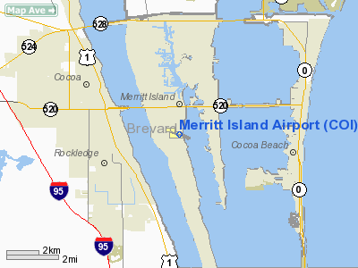
Merritt Island, Florida |
| Elevation AMSL |
7 ft / 2.1 m |
| Coordinates |
28°20′30″N 080°41′08″W / 28.34167°N 80.68556°W / 28.34167; -80.68556 |
| Runways |
| Direction |
Length |
Surface |
| ft |
m |
| 11/29 |
3,601 |
1,098 |
Asphalt |
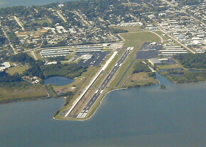
Merritt Island Airport (IATA: COI, ICAO: KCOI, FAA LID: COI) is a public airport located in Merritt Island, Brevard County, Florida, USA. Facilities
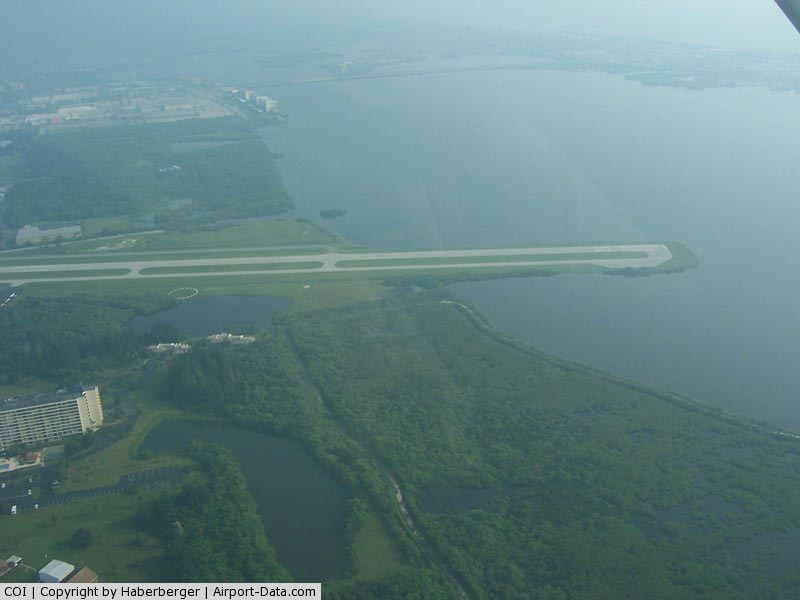
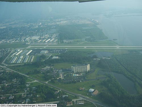
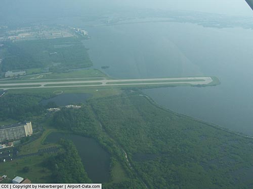
Merritt Island Airport covers 129 acres (52 ha) and has one runway:
- Runway 11/29: 3,601 x 75 ft. (1,098 x 23 m), Surface: asphalt
Businesses
- Aerocomp, an airplane manufacturer is located at the Merritt Island Airport.
- Baer Air offers aircraft charters and has a base at the airport.
- Voyager Aviation International offers flight training.
The above content comes from Wikipedia and is published under free licenses – click here to read more.
|
 |
(Click on the photo to enlarge) |
|
 |
(Click on the photo to enlarge) |
Location
& QuickFacts
|
FAA Information Effective: |
2007-01-18 |
|
Airport
Identifier: |
COI |
|
Airport
Status: |
Operational |
|
Longitude/Latitude: |
080-41-07.7000W/28-20-29.8000N
-80.685472/28.341611 (Estimated) |
|
Elevation: |
6 ft / 1.83 m (Surveyed) |
|
Land: |
129 acres |
|
From
nearest city: |
0 nautical miles S of Merritt Island, FL |
|
Location: |
Brevard County, FL |
|
Magnetic Variation: |
05W (2000) |
Owner
& Manager
|
Ownership: |
Publicly owned |
|
Owner: |
Tico Airport Authority |
|
Address: |
355 Golden Knights Blvd
Titusville, FL 32780 |
|
Phone
number: |
407-267-8780 |
|
Manager: |
Dave Edwards |
|
Address: |
355 Golden Knights Blvd
Titusville, FL 32780 |
|
Phone number: |
407-267-8780
ARPT PHONE 407-453-2222. |
Airport
Operations and Facilities
|
Airport Use: |
Open to public |
|
Wind
indicator: |
Yes |
|
Segmented
Circle: |
Yes |
|
Control
Tower: |
No |
|
Lighting
Schedule: |
RDO-CTL
ACTVT ROTG BCN - CTAF. |
|
Beacon
Color: |
Clear-Green (lighted land airport) |
|
Landing
fee charge: |
No |
|
Sectional
chart: |
Jacksonville |
|
Region: |
ASO - Southern |
|
Boundary
ARTCC: |
ZMA - Miami |
|
Responsible
ARTCC: |
ZJX - Jacksonville |
|
Tie-in
FSS: |
PIE - Saint Petersburg |
|
FSS
on Airport: |
No |
|
FSS
Toll Free: |
1-800-WX-BRIEF |
|
NOTAMs
Facility: |
PIE (NOTAM-d service avaliable) |
|
Federal Agreements: |
NGY |
Airport
Communications
|
CTAF: |
123.050 |
|
Unicom: |
123.050 |
Airport
Services
|
Fuel available: |
100LLA |
|
Airframe Repair: |
MAJOR |
|
Power Plant Repair: |
MAJOR |
|
Bottled
Oxygen: |
NONE |
|
Bulk
Oxygen: |
NONE |
|
Runway Information
Runway 11/29
|
Dimension: |
3601 x 75 ft / 1097.6 x 22.9 m |
|
Surface: |
ASPH, Fair Condition |
|
Weight
Limit: |
Single wheel: 22000 lbs. |
|
Edge
Lights: |
Medium |
|
|
Runway 11 |
Runway 29 |
|
Longitude: |
080-41-26.7564W |
080-40-48.7305W |
|
Latitude: |
28-20-35.6646N |
28-20-23.8524N |
|
Elevation: |
6.00
ft |
3.00
ft |
|
Alignment: |
109 |
127 |
|
Traffic
Pattern: |
Left |
Left |
|
Markings: |
Non-precision instrument, Fair Condition |
Non-precision instrument, Fair Condition |
|
Crossing
Height: |
33.00 ft |
33.00 ft |
|
VASI: |
2-light PAPI on left side |
2-light PAPI on left side |
|
Visual
Glide Angle: |
3.00� |
3.00� |
|
Obstruction: |
6 ft fence, 10.0 ft from runway, 250 ft right
of centerline
APCH RATIO 20:1 TO EOR.
25 FT BLDG 218 FT L OF CNTRLN 20 FT FROM EOR. |
, 50:1 slope to clear |
|
Radio Navigation
Aids
|
ID |
Type |
Name |
Ch |
Freq |
Var |
Dist |
|
COI |
NDB |
Merritt Island |
|
247.00 |
05W |
0.2 nm |
|
SQT |
NDB |
Satellite |
|
257.00 |
03W |
14.6 nm |
|
GGL |
NDB |
Geiger Lake |
|
375.00 |
05W |
16.6 nm |
|
SFB |
NDB |
Sanford |
|
408.00 |
05W |
39.7 nm |
|
ISM |
NDB |
Kissimmee |
|
329.00 |
05W |
39.7 nm |
|
VEP |
NDB |
Vero Beach |
|
392.00 |
04W |
43.1 nm |
|
EVB |
NDB |
New Smyrna Beach |
|
417.00 |
04W |
44.9 nm |
|
COF |
TACAN |
Patrick |
097X |
|
04W |
7.4 nm |
|
TTS |
TACAN |
Kennedy Space Center |
059Y |
|
00E |
17.1 nm |
|
MLB |
VOR/DME |
Melbourne |
037X |
110.00 |
02W |
14.5 nm |
|
ORL |
VORTAC |
Orlando |
059X |
112.20 |
00E |
36.4 nm |
|
VRB |
VORTAC |
Vero Beach |
120X |
117.30 |
04W |
41.2 nm |
|
VRB |
VOT |
Vero Beach |
|
111.00 |
|
43.7 nm |
Remarks
- BANNER
TOWING.
- 24
HR HELICOPTER OPNS SW RAMP.
- VFR
OPERNS ONLY.
Based Aircraft
|
Aircraft
based on field: |
225 |
|
Single
Engine Airplanes: |
174 |
|
Multi
Engine Airplanes: |
45 |
|
Helicopters: |
6 |
Operational Statistics
Time Period: 1998-07-14
- 1999-07-13
|
Aircraft
Operations: |
311/Day |
|
Air Taxi: |
1.3% |
|
General
Aviation Local: |
56.4% |
|
General
Aviation Itinerant: |
42.3% |
Merritt Island Airport
Address:
Brevard County, FL
Tel:
407-267-8780
Images
and information placed above are from
http://www.airport-data.com/airport/COI/
We
thank them for the data!
| General
Info |
| Country |
United
States |
| State |
FLORIDA
|
| FAA ID |
COI
|
| Latitude |
28-20-29.722N
|
| Longitude |
080-41-07.791W
|
| Elevation |
7 feet
|
| Near City |
MERRITT
ISLAND |
We don't guarantee the information is fresh and accurate. The data may
be wrong or outdated.
For more up-to-date information please refer to other sources.
|
|