|
 |
|
||||
|
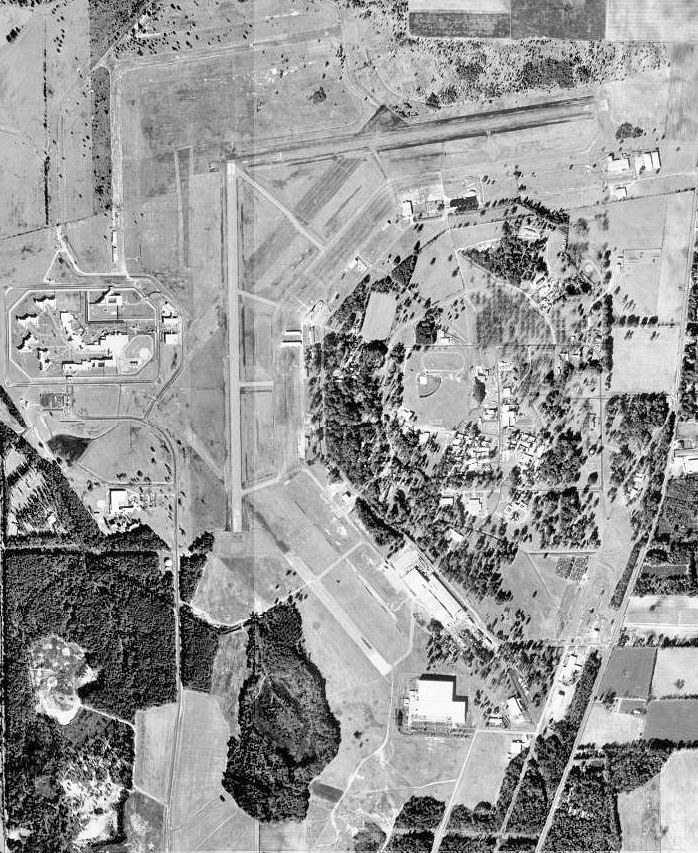
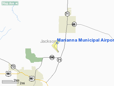
Marianna Municipal Airport (ICAO: KMAI, FAA LID: MAI) is a public use airport located four nautical miles (7 km) northeast of the central business district of Marianna, a city in Jackson County, Florida, United States. It is owned by the Marianna Municipal Airport Authority. According to the FAA's National Plan of Integrated Airport Systems for 2009–2013, it is categorized as a general aviation airport. Although many U.S. airports use the same three-letter location identifier for the FAA and IATA, this airport is assigned MAI by the FAA but has no designation from the IATA (which assigned MAI to Mangochi, Malawi). HistoryBefore World War II, the City of Marianna managed an airport at the existing airport site, which covered 635 acres (2.57 km) and included a 4,600-foot (1,400 m) long dirt runway. The federal government acquired the airport in 1942 and added 1,915 acres (7.7 km) additional to construct the Marianna Army Air Field for the U.S. Army Air Forces. The airfield opened on 8 August 1942 and eventually had six hard surface runways averaging 4,000 feet (1,200 m) in length and was used as a training base for the Southeast Army Air Force Training Command. The Army Air Forces Pilot School (Advanced-Single Engine) was activated on 1 September 1942, with the 17th Single Engine Flying Training Group being the Operational Training Unit. Aircraft used during training were After the war ended, the airfield was closed on 15 February 1946 and the Federal Government returned control of 2,010 acres (8.1 km) to the City of Marianna in 1947. In 1953, the old Marianna Army Air Field was reactivated as a United States Air Force installation under the Air Training Command (ATC) in response to increased demands for pilots as a result of the Cold War and the associated increase in number of Air Force combat flying wings, especially within the Strategic Air Command. The facility was activated on 27 January 1953 and renamed Graham Air Base for William J. Graham, a civilian instructor who provided primary flight training to pilots and headed the school. Graham AB replaced Greenville AFB, Mississippi as a contract pilot training school as Greenville AFB became an ATC basic single engine and jet pilot training school. The 3300th Pilot Training Squadron was reassigned from Greenville to Marianna to support the mission, with predominantly civilian instructors providing training in USAF T-34 Mentor and T-28 Trojan aircraft, graduating a group of USAF student pilots from primary training every six weeks. Because its short runways could not readily accommodate the USAF jet trainers of the period, student pilots completing primary training were then assigned to other air force bases with longer runways for more advanced training in aircraft such as the T-33 Shooting Star. Although its instructor cadre was primarily civilian, Graham AB was still an Air Force installation with a overall military cadre in command and operated under constant military supervision. Students were a combination of both commissioned USAF officers and non-commissioned air cadets, the latter who would receive their commissions upon completion of flight training. New bachelor officer quarters, cadet barracks and other facilities were built, and by 1953 military personnel began arriving and were greeted warmly by the residents of Jackson County. The air base ultimately employed 700 civilians. In August 1959, the Air Force begand replacing their prop-driven T-28s with the first T-37 Tweet jet trainers. By 1960, the Air Force began to transition to the Undergraduate Pilot Training (UPT) concept at selected Air Training Command installations with longer runways which would eventually host T-37 and T-38 Talon jet trainers. Facilities like Graham AB, with civilian contractor instructors and short runways became obsolete and were eventually closed in the early 1960s. The Air Force decided to close Graham AB in late 1960, despite the efforts of influential Florida Congressman Robert L. F. Sikes (D-FL) to keep it running. Jackson County lost a combined military and civilian payroll of $6 million, along with several hundred military and contractor families. As the installation was being scaled down as a military facility, the industrial committee of the Junior Chamber of Commerce began working to adapt the air base into a combination industrial park and civilian airport. The 3300th Training Squadron was inactivated on 1 February 1961. ATC wanted to close the base in March, but an Air Force imposed freeze on shipping property delayed its final closure. However, on 31 August 1961 the base was turned over to civil control. Today the Marianna Municipal Airport has two 4,900-foot (1,500 m) long by 100-foot (30 m) wide intersecting hard surface runways with a pavement strength of 56,500 pounds single wheel load. Runway 18/36 serves as the primary runway. Although the original USAF control tower and base operations building remain standing on the flight line, the airport has remained an uncontrolled field for its entire time as a civilian facility. In addition to its civilian general aviation traffic, the airport continues to see significant use by military aircraft, with one third of the airport's daily operations normally consisting of transient military training flights, primarily Army helicopters from Fort Rucker and Navy helicopters from NAS Whiting Field. Facilities and aircraftMarianna Municipal Airport covers an area of 2,400 acres (971 ha) at an elevation of 110 feet (34 m) above mean sea level. It has two asphalt paved runways: 8/26 is 4,895 by 100 feet (1,492 x 30 m) and 18/36 is 4,896 by 100 feet (1,492 x 30 m). For the 12-month period ending March 9, 2009, the airport had 28,016 aircraft operations, an average of 76 per day: 67% general aviation and 33% military. At that time there were 30 aircraft based at this airport: 66.7% single-engine, 20% multi-engine, 6.7% helicopter and 6.7% glider. The above content comes from Wikipedia and is published under free licenses – click here to read more.
Runway InformationRunway 08/26
Runway 18/36
Radio Navigation Aids
Remarks
Based Aircraft
Operational StatisticsTime Period: 1998-11-19 - 1999-11-18
Marianna Municipal Airport Address: Jackson County, FL Tel: 850-482-4761, 850-482-2281 Images
and information placed above are from We thank them for the data!
We don't guarantee the information is fresh and accurate. The data may
be wrong or outdated.
|
||||||||||||||||||||||||||||||||||||||||||||||||||||||||||||||||||||||||||||||||||||||||||||||||||||||||||||||||||||||||||||||||||||||||||||||||||||||||||||||||||||||||||||||||||||||||||||||||||||||||||||||||||||||||||||||||||||||||||||||||||||||||||||||||||||||||||||||||||||||||||||||||||||||||||||||||||||||||||||||||||||||||||||||||||||||||||||||||||||||||||||||||||||||||||||||||||||||||||||||||||||

 |
|
Copyright 2004-2026 © by Airports-Worldwide.com, Vyshenskoho st. 36, Lviv 79010, Ukraine Legal Disclaimer |