 |
|
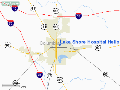
Lake Shore Hospital Heliport |
Location
& QuickFacts
|
FAA Information Effective: |
2007-01-18 |
|
Airport
Identifier: |
86FL |
|
Airport
Status: |
Operational |
|
Longitude/Latitude: |
082-37-48.4430W/30-11-35.8320N
-82.630123/30.193287 (Estimated) |
|
Elevation: |
190 ft / 57.91 m (Estimated) |
|
Land: |
0 acres |
|
From
nearest city: |
1 nautical miles NE of Lake City, FL |
|
Location: |
Columbia County, FL |
|
Magnetic Variation: |
02W (1985) |
Owner
& Manager
|
Ownership: |
Privately owned |
|
Owner: |
Lake Shore Hosp Auth |
|
Address: |
Circle Drive
Lake City, FL 32055 |
|
Phone
number: |
904-755-3200 |
|
Manager: |
John T Myles |
|
Address: |
Circle Drive
Lake City, FL 32055 |
|
Phone number: |
904-755-3200 |
Airport
Operations and Facilities
|
Airport Use: |
Private
MEDICAL. |
|
Wind
indicator: |
Yes |
|
Segmented
Circle: |
No |
|
Control
Tower: |
No |
|
Sectional
chart: |
Jacksonville |
|
Region: |
ASO - Southern |
|
Boundary
ARTCC: |
ZJX - Jacksonville |
|
Tie-in
FSS: |
GNV - Gainesville |
|
FSS
Phone: |
850-377-3291 |
|
FSS
Toll Free: |
1-800-WX-BRIEF |
|
Runway Information
Helipad H1
|
Dimension: |
40 x 40 ft / 12.2 x 12.2 m |
|
Surface: |
CONC, |
|
|
Runway H1 |
Runway |
|
Traffic
Pattern: |
Left |
Left |
|
Radio Navigation
Aids
|
ID |
Type |
Name |
Ch |
Freq |
Var |
Dist |
|
LCQ |
NDB |
Lake City |
|
204.00 |
03W |
2.7 nm |
|
GN |
NDB |
Wynds |
|
269.00 |
04W |
39.5 nm |
|
HEG |
NDB |
Herlong |
|
332.00 |
02W |
42.9 nm |
|
JA |
NDB |
Dinns |
|
344.00 |
03W |
46.0 nm |
|
NZC |
TACAN |
Cecil/dcmsnd |
088X |
|
04W |
39.5 nm |
|
NIP |
TACAN |
Jacksonville |
19X |
|
04W |
49.7 nm |
|
VQQ |
VOR |
Cecil |
|
117.90 |
03W |
38.4 nm |
|
OTK |
VOR/DME |
Valdosta |
095X |
114.80 |
02W |
48.8 nm |
|
TAY |
VORTAC |
Taylor |
076X |
112.90 |
03W |
19.1 nm |
|
GNV |
VORTAC |
Gators |
109X |
116.20 |
04W |
35.4 nm |
|
CTY |
VORTAC |
Cross City |
057X |
112.00 |
02W |
41.9 nm |
Remarks
Lake Shore Hospital Heliport
Address:
Columbia County, FL
Tel:
904-755-3200
Images
and information placed above are from
http://www.airport-data.com/airport/86FL/
We
thank them for the data!
| General
Info |
| Country |
United
States |
| State |
FLORIDA
|
| FAA ID |
86FL
|
| Latitude |
30-11-35.832N
|
| Longitude |
082-37-48.443W
|
| Elevation |
190 feet
|
| Near City |
LAKE CITY
|
We don't guarantee the information is fresh and accurate. The data may
be wrong or outdated.
For more up-to-date information please refer to other sources.
|
|


