 |
|
Lake City Municipal Airport |
Coordinates: 30°10′55″N 082°34′37″W / 30.18194°N 82.57694°W / 30.18194; -82.57694
| Lake City Municipal Airport |
| IATA: LCQ – ICAO: KLCQ – FAA LID: LCQ |
| Summary |
| Airport type |
Public |
| Owner |
Lake City |
| Serves |
Lake City, Florida |
| Elevation AMSL |
201 ft / 61 m |
| Website |
lakecitymunicipalfbo.com |
| Runways |
| Direction |
Length |
Surface |
| ft |
m |
| 10/28 |
8,003 |
2,439 |
Asphalt |
| 5/23 |
4,000 |
1,219 |
Asphalt |
| Statistics (1998) |
| Aircraft operations |
28,714 |
| Based aircraft |
26 |
| Source: Federal Aviation Administration |
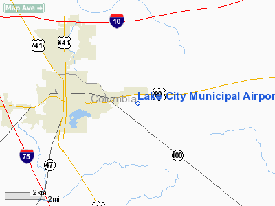
Lake City Municipal Airport (IATA: LCQ, ICAO: KLCQ, FAA LID: LCQ) is a city-owned public-use airport located three miles (5 km) east of the central business district of Lake City, in Columbia County, Florida, United States.
Besides typical general aviation use, the airport also hosts a major aviation industrial facility fomerly known as Aero Corporation, since acquired by TIMCO Aviation Services:
- TIMCO [1] modifies and repairs large aircraft, such as commercial Boeing 727 and Boeing 737 airliners and the military C-130 Hercules and P-3 Orion aircraft for US military and US civilian operators, as well as overseas military and civilian customers.
The airport was originally built by the U.S. Navy during World War II to facilitate pilot training and named Naval Air Station Lake City. Commissioned in December 1942, NAS Lake City was located on the site of the Lake City Flying Club air field east of town. Established as one of several support facilities to NAS Jacksonville, NAS Lake City was used to train U.S. Navy and U.S. Marine Corps pilots in land-based PV-1 Venturas and PV-2 Harpoons. Maximum complement at the air station reached 290 officers and 1,150 enlisted personnel. As many as 200 WAVES were stationed at NAS Lake City later in the war and served in air traffic control, meteorological services, administrative support, and aircraft maintenance. The airfield southeast of Lake Butler served as an outlying field (OLF) and Cedar Key, Alachua and Gainesville provided auxiliary fields. Regular military operations terminated in March 1946 and NAS Lake City was decommissioned as an active naval air station.
The NAS Lake City property was deemed surplus and subsequently conveyed to the city of Lake City by the General Services Administration. Aero Corporation performed aircraft modification and rehabilitation during the 1960s, 1970s and 1980s, mostly U.S. military contracts. Aero Corporation was subsequently acquired by TIMCO, the current tenant.
Facilities and aircraft
Lake City Municipal Airport covers an area of 1,250 acres (506 ha) which contains two asphalt paved runways: 10/28 measuring 8,003 x 150 ft (2,439 x 46 m) and 5/23 measuring 4,000 x 75 ft (1,219 x 23 m).
For the 12-month period ending May 5, 1998, the airport had 28,714 aircraft operations, an average of 78 per day: 86% general aviation, 9% military and 5% air taxi. Although the Navy departed Lake City over 60 years ago, its comparatively long main runway (8,003 feet), operational Non-Federal Air Traffic Control Tower, and minimal air traffic makes it a popular location for transient P-3C Orions from NAS Jacksonville and HC-130 Hercules and A-10 Thunderbolt II aircraft from Moody AFB to practice approaches and touch-and-go landings. The airport also has a Department of Defense into-plane refueling contract for Jet A fuel, otherwise known as "contract fuel," for military aircraft. There are 26 aircraft based at this airport: 88% single-engine and 12% multi-engine.
The above content comes from Wikipedia and is published under free licenses – click here to read more.
Location
& QuickFacts
|
FAA Information Effective: |
2007-01-18 |
|
Airport
Identifier: |
LCQ |
|
Airport
Status: |
Operational |
|
Longitude/Latitude: |
082-34-36.7000W/30-10-55.4000N
-82.576861/30.182056 (Estimated) |
|
Elevation: |
201 ft / 61.26 m (Surveyed) |
|
Land: |
1250 acres |
|
From
nearest city: |
3 nautical miles E of Lake City, FL |
|
Location: |
Columbia County, FL |
|
Magnetic Variation: |
03W (1990) |
Owner
& Manager
|
Ownership: |
Publicly owned |
|
Owner: |
Lake City |
|
Address: |
Po Box 1687
Lake City, FL 32056 |
|
Phone
number: |
904-752-1066 |
|
Manager: |
Faye Bowling |
|
Address: |
Po Box 1687
Lake City, FL 32056 |
|
Phone number: |
904-752-2031 |
Airport
Operations and Facilities
|
Airport Use: |
Open to public |
|
Wind
indicator: |
Yes |
|
Segmented
Circle: |
Yes |
|
Control
Tower: |
Yes |
|
Lighting
Schedule: |
DUSK-DAWN
ACTVT MIRL RYS 05/23 & 10/28, VASI RYS 10 & 28 AND
REIL RY 28 - 122.7. |
|
Beacon
Color: |
Clear-Green (lighted land airport) |
|
Landing
fee charge: |
No |
|
Sectional
chart: |
Jacksonville |
|
Region: |
ASO - Southern |
|
Boundary
ARTCC: |
ZJX - Jacksonville |
|
Tie-in
FSS: |
GNV - Gainesville |
|
FSS
on Airport: |
No |
|
FSS
Phone: |
850-377-3291 |
|
FSS
Toll Free: |
1-800-WX-BRIEF |
|
NOTAMs
Facility: |
GNV (NOTAM-d service avaliable) |
|
Federal Agreements: |
NGPRY3 |
Airport
Communications
|
CTAF: |
119.200 |
|
Unicom: |
122.700 |
Airport
Services
|
Fuel available: |
100LLA |
|
Airframe Repair: |
MAJOR |
|
Power Plant Repair: |
MAJOR |
|
Bottled
Oxygen: |
NONE |
|
Bulk
Oxygen: |
NONE |
|
Runway Information
Runway 05/23
|
Dimension: |
4000 x 75 ft / 1219.2 x 22.9 m |
|
Surface: |
ASPH, Good Condition |
|
Edge
Lights: |
Medium |
|
|
Runway 05 |
Runway 23 |
|
Longitude: |
082-34-49.7995W |
082-34-13.8344W |
|
Latitude: |
30-10-38.4330N |
30-11-02.7892N |
|
Elevation: |
186.00 ft |
195.00 ft |
|
Alignment: |
52 |
127 |
|
Traffic
Pattern: |
Left |
Left |
|
Markings: |
Basic, Good Condition |
Basic, Good Condition |
|
Obstruction: |
36 ft trees, 600.0 ft from runway, 225 ft left
of centerline, 11:1 slope to clear
RY 05 APCH SLOPE 16:1 TO RY END. |
32 ft trees, 1500.0 ft from runway, 40:1 slope
to clear |
|
Runway 10/28
|
Dimension: |
8003 x 150 ft / 2439.3 x 45.7 m |
|
Surface: |
ASPH, Good Condition |
|
Weight
Limit: |
Single wheel: 75000 lbs.
Dual wheel: 105000 lbs.
Dual
tandem wheel: 250000 lbs. |
|
Edge
Lights: |
Medium |
|
|
Runway 10 |
Runway 28 |
|
Longitude: |
082-35-24.4358W |
082-33-53.9557W |
|
Latitude: |
30-11-02.6146N |
30-10-52.8953N |
|
Elevation: |
198.00 ft |
196.00 ft |
|
Alignment: |
97 |
127 |
|
Traffic
Pattern: |
Left |
Right |
|
Markings: |
Non-precision instrument, Good Condition |
Non-precision instrument, Good Condition |
|
Crossing
Height: |
31.00 ft |
31.00 ft |
|
VASI: |
4-box on left side |
4-box on left side |
|
Visual
Glide Angle: |
3.00� |
3.00� |
|
Runway
End Identifier: |
|
Yes |
|
Obstruction: |
48 ft trees, 1400.0 ft from runway, 25:1 slope
to clear |
35 ft trees, 1600.0 ft from runway, 40:1 slope
to clear |
|
Radio Navigation
Aids
|
ID |
Type |
Name |
Ch |
Freq |
Var |
Dist |
|
LCQ |
NDB |
Lake City |
|
204.00 |
03W |
0.2 nm |
|
GN |
NDB |
Wynds |
|
269.00 |
04W |
37.3 nm |
|
HEG |
NDB |
Herlong |
|
332.00 |
02W |
40.3 nm |
|
JA |
NDB |
Dinns |
|
344.00 |
03W |
43.7 nm |
|
NZC |
TACAN |
Cecil/dcmsnd |
088X |
|
04W |
36.7 nm |
|
NIP |
TACAN |
Jacksonville |
19X |
|
04W |
47.0 nm |
|
VQQ |
VOR |
Cecil |
|
117.90 |
03W |
35.7 nm |
|
TAY |
VORTAC |
Taylor |
076X |
112.90 |
03W |
19.4 nm |
|
GNV |
VORTAC |
Gators |
109X |
116.20 |
04W |
33.4 nm |
|
CTY |
VORTAC |
Cross City |
057X |
112.00 |
02W |
42.8 nm |
|
JAX |
VOT |
Jacksonville Intl |
|
111.00 |
|
49.7 nm |
Remarks
- UNLIT
60 FT POLES ON MOVEMENT AREA. HELICOPTERS ADVISED TO TAXI ON PAVED AREAS
ONLY.
- TREES
IN TRANSITIONAL SFC N OF AER 05.
Based Aircraft
|
Aircraft
based on field: |
26 |
|
Single
Engine Airplanes: |
23 |
|
Multi
Engine Airplanes: |
3 |
Operational Statistics
Time Period: 1997-05-06
- 1998-05-05
|
Aircraft
Operations: |
79/Day |
|
Air Taxi: |
4.5% |
|
General
Aviation Local: |
38.7% |
|
General
Aviation Itinerant: |
47.7% |
|
Military: |
9.1% |
Lake City Municipal Airport
Address:
Columbia County, FL
Tel:
904-752-1066,
904-752-2031
Images
and information placed above are from
http://www.airport-data.com/airport/LCQ/
We
thank them for the data!
| General
Info |
| Country |
United
States |
| State |
FLORIDA
|
| FAA ID |
LCQ
|
| Latitude |
30-10-55.400N
|
| Longitude |
082-34-36.700W
|
| Elevation |
201 feet
|
| Near City |
LAKE CITY
|
We don't guarantee the information is fresh and accurate. The data may
be wrong or outdated.
For more up-to-date information please refer to other sources.
|
|


