 |
|
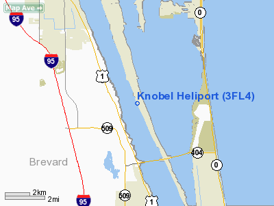
Location
& QuickFacts
|
FAA Information Effective: |
2007-01-18 |
|
Airport
Identifier: |
3FL4 |
|
Airport
Status: |
Operational |
|
Longitude/Latitude: |
080-39-43.0900W/28-14-54.4300N
-80.661969/28.248453 (Estimated) |
|
Elevation: |
38 ft / 11.58 m (Estimated) |
|
Land: |
0 acres |
|
From
nearest city: |
5 nautical miles SE of Cocoa, FL |
|
Location: |
Brevard County, FL |
|
Magnetic Variation: |
04W (1995) |
Owner
& Manager
|
Ownership: |
Privately owned |
|
Owner: |
Jjk Co Lc & Heinz Knobel |
|
Address: |
6455 South Tropical Terrace
Merritt Island, FL 32952 |
|
Phone number: |
407-723-8200 |
|
Address: |
|
Airport
Operations and Facilities
|
Airport Use: |
Private |
|
Wind
indicator: |
Yes |
|
Segmented
Circle: |
No |
|
Control
Tower: |
No |
|
Sectional
chart: |
Jacksonville |
|
Region: |
ASO - Southern |
|
Boundary
ARTCC: |
ZMA - Miami |
|
Tie-in
FSS: |
PIE - Saint Petersburg |
|
FSS
Toll Free: |
1-800-WX-BRIEF |
|
Runway Information
Helipad H1
|
Dimension: |
25
x 25 ft / 7.6 x 7.6 m |
|
Surface: |
CONC, |
|
|
Runway H1 |
Runway |
|
Traffic
Pattern: |
Left |
Left |
|
Radio Navigation
Aids
|
ID |
Type |
Name |
Ch |
Freq |
Var |
Dist |
|
COI |
NDB |
Merritt Island |
|
247.00 |
05W |
5.7 nm |
|
SQT |
NDB |
Satellite |
|
257.00 |
03W |
9.2 nm |
|
GGL |
NDB |
Geiger Lake |
|
375.00 |
05W |
22.3 nm |
|
VEP |
NDB |
Vero Beach |
|
392.00 |
04W |
37.4 nm |
|
ISM |
NDB |
Kissimmee |
|
329.00 |
05W |
41.0 nm |
|
SFB |
NDB |
Sanford |
|
408.00 |
05W |
44.5 nm |
|
FPR |
NDB |
Fort Pierce |
|
275.00 |
04W |
48.3 nm |
|
COF |
TACAN |
Patrick |
097X |
|
04W |
2.7 nm |
|
TTS |
TACAN |
Kennedy Space Center |
059Y |
|
00E |
22.8 nm |
|
MLB |
VOR/DME |
Melbourne |
037X |
110.00 |
02W |
8.7 nm |
|
VRB |
VORTAC |
Vero Beach |
120X |
117.30 |
04W |
35.5 nm |
|
ORL |
VORTAC |
Orlando |
059X |
112.20 |
00E |
39.7 nm |
|
VRB |
VOT |
Vero Beach |
|
111.00 |
|
38.0 nm |
Remarks
- 35
FT POWER LINES 375 FT NORTH & 490 FT EAST OF HELIPAD.
- PRVDD
VFR, PVT USE ONLY, APCH/DEP ROUTES CONDUCTED FROM 120 CLKWS 160 AND
300 CLKWS 340 USING PAD AS CENTER, AREA MKD, WIND INDICATOR MAINTAINED,
HELICOPTER HAS WORKING RADIO, CLASS D GUIDANCE & RESTRICTIONS FOLLOWED.
Based
Aircraft
|
Aircraft
based on field: |
1 |
|
Helicopters: |
1 |
Knobel Heliport
Address:
Brevard County, FL
Tel:
407-723-8200
Images
and information placed above are from
http://www.airport-data.com/airport/3FL4/
We
thank them for the data!
| General
Info |
| Country |
United
States |
| State |
FLORIDA
|
| FAA ID |
3FL4
|
| Latitude |
28-14-54.430N
|
| Longitude |
080-39-43.090W
|
| Elevation |
38 feet
|
| Near City |
COCOA
|
We don't guarantee the information is fresh and accurate. The data may
be wrong or outdated.
For more up-to-date information please refer to other sources.
|
|


