|
|
Kissimmee Gateway Airport |
Coordinates: 28°17′23″N 081°26′14″W / 28.28972°N 81.43722°W / 28.28972; -81.43722
| Kissimmee Gateway Airport |
| IATA: ISM – ICAO: KISM – FAA LID: ISM |
| Summary |
| Airport type |
Public |
| Owner/Operator |
City of Kissimmee |
| Serves |
Orlando, Florida |
| Location |
Kissimmee, Florida |
| Elevation AMSL |
82 ft / 25 m |
| Website |
www.KissimmeeAirport.com |
| Runways |
| Direction |
Length |
Surface |
| ft |
m |
| 6/24 |
5,000 |
1,524 |
Asphalt |
| 15/33 |
6,000 |
1,829 |
Asphalt |
| Statistics (2001) |
| Aircraft operations |
150,388 |
| Based aircraft |
206 |
| Sources: Airport website and FAA |
 | |
Emblem of Air University |
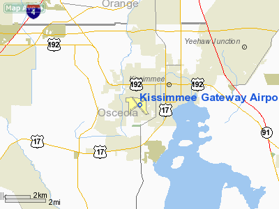
Kissimmee Gateway Airport (IATA: ISM, ICAO: KISM, FAA LID: ISM), formerly known as Kissimmee Municipal Airport, is a public airport in Kissimmee, a city in Osceola County, Florida, United States. The airport is located 16 nautical miles (30 km) southwest of the central business district of Orlando. It is owned and operated by the City of Kissimmee. Facilities and aircraft
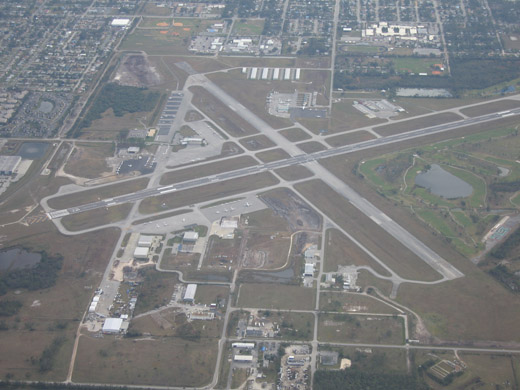 | |
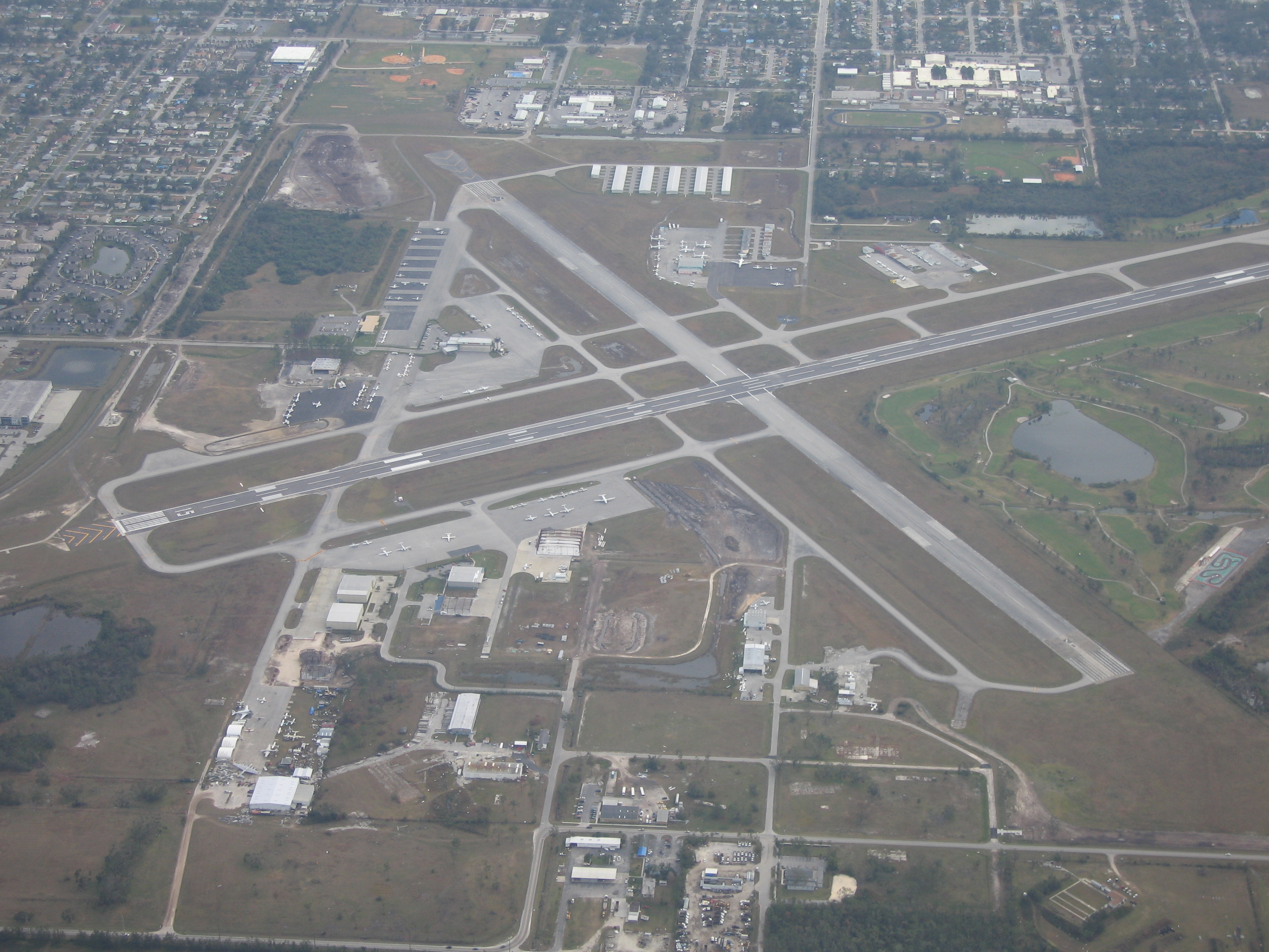
Aerial view of Kissimmee Gateway Airport |
Kissimmee Gateway Airport covers an area of 892 acres (361 ha) which contains two asphalt paved runways: 6/24 measuring 5,000 x 150 ft (1,524 x 46 m) and 15/33 measuring 6,000 x 100 ft (1,829 x 30 m). Today it hosts a variety of general aviation aircraft operations, including a major facility for the restoration of classic military aircraft from the World War II era to flying condition. The airport has an operational control tower and a Category I instrument landing system (ILS) on its main runway. It is considered a general aviation reliever airport to Orlando International Airport.
For the 12-month period ending December 31, 2001, the airport had 150,388 aircraft operations, an average of 412 per day: 98% general aviation, 2% air taxi, <1% military and <1% scheduled commercial. There are 206 aircraft based at this airport: 71% single-engine, 22% multi-engine, 4% jet and 3% helicopter.
Passenger Service:
- None. DayJet provided "on-demand" service to 12 cities, but suspended all operations in September 2008.
History
The airport opened in April 1940 by the United States Army Air Forces. Known as Kissimmee Army Airfield, it was used as part of the Air University Army Air Forces School of Applied Tactics (AAFSAT) tactical combat simulation school in Central and Northern Florida.
Headquartered at Orlando Army Air Base, the school's mission was to develop tactics and techniques of aerial warfare and to establish technical and tactical proficiency requirements for combat units to effectively engage and defeat enemy air forces. This was done with a wide variety of aircraft, including heavy strategic bombers; tactical fighters; medium and light bombers; reconnaissance and dive bombers, based at different airfields of the school.
The 99th Bombardment Squadron flew B-25 Mitchells and B-26 Marauder medium bombers from the airfield.
The major use of Kissimmee AAF was Night Fighter Training, with numerous squadrons training at the airfield in 1943 and 1944. Known Night Fighter units that trained at the airfield were:
- 349th Night Fighter Squadron, 1 January 1943-15 January 1944 (DB-7/P-70 (A-20) Havoc), (B-25 Mitchell)
- 414th Night Fighter Squadron, 8 February-21 April 1943 (P-70/A-20 Havoc)
- 415th Night Fighter Squadron, 8 February-21 April 1943 (P-70/A-20 Havoc)
- 417th Night Fighter Squadron, 5 March-26 April 1943 (P-70/A-20 Havoc)
- 419th Night Fighter Squadron, 22 April-15 October 1943 (P-70/A-20 Havoc)
- 420th Night Fighter Squadron, 1 June-20 August 1943 (P-70/A-20 Havoc)
- 418th Night Fighter Squadron, 25 August-25 September 1943 (P-70/A-20 Havoc)
- 421st Night Fighter Squadron, 4 October-7 November 1943 (P-70/A-20 Havoc)
- 422d Night Fighter Squadron, 3 November 1943-6 January 1944 (P-70/A-20 Havoc)
Night fighter training was moved to southern California in January 1944, and the military use of the field was phased down. The airfield was closed on 7 July 1945 and returned to civilian use by the end of the year.
The above content comes from Wikipedia and is published under free licenses – click here to read more.
Location
& QuickFacts
|
FAA Information Effective: |
2007-01-18 |
|
Airport
Identifier: |
ISM |
|
Airport
Status: |
Operational |
|
Longitude/Latitude: |
081-26-13.5000W/28-17-23.3000N
-81.437083/28.289806 (Estimated) |
|
Elevation: |
82 ft / 24.99 m (Surveyed) |
|
Land: |
892 acres |
|
From
nearest city: |
16 nautical miles SW of Orlando, FL |
|
Location: |
Osceola County, FL |
|
Magnetic Variation: |
05W (2000) |
Owner
& Manager
|
Ownership: |
Publicly owned |
|
Owner: |
City Of Kissimmee |
|
Address: |
301 Dyer Blvd Suite 101
Kissimmee, FL 34741-4613 |
|
Phone
number: |
407-847-4600 |
|
Manager: |
Terry Lloyd |
|
Address: |
301 Dyer Blvd Suite 101
Kissimmee, FL 34741-4613 |
|
Phone number: |
407-847-4600
FAX 407-847-8399 AMGR. |
Airport
Operations and Facilities
|
Airport Use: |
Open to public |
|
Wind
indicator: |
Yes |
|
Segmented
Circle: |
Yes |
|
Control
Tower: |
Yes |
|
Lighting
Schedule: |
DUSK-DAWN
MIRL RY 15/33 & RY 06/24 PRESET LOW INTST DUSK-2200;
TO INCR INTST & ACTVT AFTER 2200 - CTAF.
ACTVT
PAPI RYS 06, 24, 15 & 33 - CTAF. |
|
Beacon
Color: |
Clear-Green (lighted land airport) |
|
Landing
fee charge: |
No |
|
Sectional
chart: |
Jacksonville |
|
Region: |
ASO - Southern |
|
Boundary
ARTCC: |
ZMA - Miami |
|
Responsible
ARTCC: |
ZJX - Jacksonville |
|
Tie-in
FSS: |
PIE - Saint Petersburg |
|
FSS
on Airport: |
No |
|
FSS
Toll Free: |
1-800-WX-BRIEF |
|
NOTAMs
Facility: |
ISM (NOTAM-d service avaliable) |
|
Federal Agreements: |
NGPRY3 |
Airport
Communications
|
CTAF: |
124.450 |
|
Unicom: |
122.950 |
Airport
Services
|
Fuel available: |
100LLA |
|
Airframe Repair: |
MAJOR |
|
Power Plant Repair: |
MAJOR |
|
Bottled
Oxygen: |
NONE |
|
Bulk
Oxygen: |
HIGH |
|
Runway Information
Runway 06/24
|
Dimension: |
5000 x 150 ft / 1524.0 x 45.7 m |
|
Surface: |
ASPH, Good Condition |
|
Surface
Treatment: |
Saw-cut or plastic Grooved |
|
Weight
Limit: |
Single wheel: 30000 lbs.
Dual wheel: 60000 lbs. |
|
Edge
Lights: |
Medium |
|
|
Runway 06 |
Runway 24 |
|
Longitude: |
081-26-38.5767W |
081-25-51.1108W |
|
Latitude: |
28-17-12.6405N |
28-17-38.8316N |
|
Elevation: |
80.00 ft |
78.00 ft |
|
Alignment: |
58 |
127 |
|
Traffic
Pattern: |
Right |
Left |
|
Markings: |
Non-precision instrument, Fair Condition |
Non-precision instrument, Good Condition |
|
Crossing
Height: |
45.00 ft |
45.00 ft |
|
VASI: |
4-light PAPI on left side |
4-light PAPI on left side |
|
Visual
Glide Angle: |
3.00� |
3.00� |
|
Obstruction: |
32 ft trees, 1000.0 ft from runway, 25:1 slope
to clear |
2400 ft trees, 47.0 ft from runway, 34:1 slope
to clear |
|
Runway 15/33
|
Dimension: |
6000 x 100 ft / 1828.8 x 30.5 m |
|
Surface: |
ASPH, Good Condition |
|
Surface
Treatment: |
Saw-cut or plastic Grooved |
|
Weight
Limit: |
Single wheel: 75000 lbs.
Dual wheel: 75000 lbs.
Dual
tandem wheel: 120000 lbs. |
|
Edge
Lights: |
Medium |
|
|
Runway 15 |
Runway 33 |
|
Longitude: |
081-26-30.1108W |
081-25-54.6251W |
|
Latitude: |
28-17-46.4898N |
28-16-56.0650N |
|
Elevation: |
80.00 ft |
77.00 ft |
|
Alignment: |
127 |
127 |
|
ILS
Type: |
ILS/DME |
|
|
Traffic
Pattern: |
Right |
Left |
|
Markings: |
Non-precision instrument, Fair Condition |
Non-precision instrument, Good Condition |
|
Crossing
Height: |
45.00 ft |
45.00 ft |
|
VASI: |
4-light PAPI on left side |
4-light PAPI on left side |
|
Visual
Glide Angle: |
3.00� |
3.00� |
|
Obstruction: |
24 ft trees, 800.0 ft from runway, 25:1 slope
to clear |
57 ft trees, 1150.0 ft from runway, 16:1 slope
to clear |
|
Radio Navigation
Aids
|
ID |
Type |
Name |
Ch |
Freq |
Var |
Dist |
|
ISM |
NDB |
Kissimmee |
|
329.00 |
05W |
0.2 nm |
|
SFB |
NDB |
Sanford |
|
408.00 |
05W |
31.5 nm |
|
LEE |
NDB |
Leesburg |
|
335.00 |
04W |
37.3 nm |
|
GGL |
NDB |
Geiger Lake |
|
375.00 |
05W |
37.5 nm |
|
RHZ |
NDB |
Zephyrhills |
|
253.00 |
03W |
38.3 nm |
|
COI |
NDB |
Merritt Island |
|
247.00 |
05W |
39.7 nm |
|
SQT |
NDB |
Satellite |
|
257.00 |
03W |
40.6 nm |
|
PCM |
NDB |
Plant City |
|
346.00 |
02W |
41.9 nm |
|
DED |
NDB |
Deland/dcmsnd |
|
201.00 |
05W |
47.5 nm |
|
COF |
TACAN |
Patrick |
097X |
|
04W |
43.8 nm |
|
TTS |
TACAN |
Kennedy Space Center |
059Y |
|
00E |
44.1 nm |
|
MLB |
VOR/DME |
Melbourne |
037X |
110.00 |
02W |
43.9 nm |
|
ORL |
VORTAC |
Orlando |
059X |
112.20 |
00E |
16.1 nm |
|
LAL |
VORTAC |
Lakeland |
107X |
116.00 |
01E |
35.6 nm |
Remarks
- NOISE
SENSITIVE AREA 1/2 MILE NORTH OF AER 24. NO EARLY TURNOUTS ON RY 6 DEPS.
- REQ
ALL JETS/TURBO PROPS USE NBAA CLOSE-IN PROCEDURES.
- RY
15 IS PREFERRED CALM WIND RY.
- ISM
CLSD TO ULTRALGT ACFT EXCEPT BY PRIOR PERMISSION FR AMGR.
Based Aircraft
|
Aircraft
based on field: |
206 |
|
Single
Engine Airplanes: |
146 |
|
Multi
Engine Airplanes: |
46 |
|
Jet Engine
Airplanes: |
8 |
|
Helicopters: |
6 |
Operational Statistics
Time Period: 2001-01-01
- 2001-12-31
|
Aircraft
Operations: |
413/Day |
|
Commerical: |
0.0% |
|
Air Taxi: |
1.5% |
|
General
Aviation Local: |
48.2% |
|
General
Aviation Itinerant: |
50.1% |
|
Military: |
0.1% |
Kissimmee Gateway Airport
Address:
Osceola County, FL
Tel:
407-847-4600
Fax:
407-847-8399
Images
and information placed above are from
http://www.airport-data.com/airport/ISM/
We
thank them for the data!
| General
Info |
| Country |
United
States |
| State |
FLORIDA
|
| FAA ID |
ISM
|
| Latitude |
28-17-23.300N
|
| Longitude |
081-26-13.500W
|
| Elevation |
82 feet
|
| Near City |
ORLANDO
|
We don't guarantee the information is fresh and accurate. The data may
be wrong or outdated.
For more up-to-date information please refer to other sources.
|
|