 |
|
Kendall-Tamiami Executive Airport |
Coordinates: 25°38′52″N 080°25′58″W / 25.64778°N 80.43278°W / 25.64778; -80.43278
| Kendall-Tamiami Executive Airport |
| IATA: TMB – ICAO: KTMB – FAA LID: TMB |
| Summary |
| Airport type |
Public |
| Owner |
Miami-Dade County |
| Operator |
Miami-Dade Aviation Department (MDAD) |
| Serves |
Miami, Florida |
| Location |
Miami-Dade County, Florida |
| Elevation AMSL |
8 ft / 2 m |
| Website |
www.miami-airport.com/... |
| Runways |
| Direction |
Length |
Surface |
| ft |
m |
| 9L/27R |
5,003 |
1,525 |
Asphalt |
| 9R/27L |
5,002 |
1,525 |
Asphalt |
| 13/31 |
4,001 |
1,220 |
Asphalt |
| Statistics (2001) |
| Aircraft operations |
186,653 |
| Based aircraft |
450 |
| Source: Federal Aviation Administration |
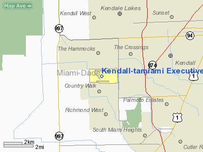
Kendall-Tamiami Executive Airport (IATA: TMB, ICAO: KTMB, FAA LID: TMB) is a public airport located in unincorporated Miami-Dade County, Florida, United States, 13 miles (21 km) southwest of the central business district of Miami.
The airport was originally called Tamiami Airport for its location next to the Tamiami Trail. Growth of the surrounding area and the nearby flight path for Miami International Airport forced the airport to relocate further to the southwest, near the community of Kendall. Florida International University is now located on the site of the old Tamiami Airport. The Kendall-Tamiami airport is owned and operated by the Miami-Dade Aviation Department. There are 450 aircraft based there, primarily light single-engine propeller planes.
The airport is a port of entry with U.S. Customs personnel on hand, although it is not certified for commercial airline use. In recent years, it has gained increasing popularity as a corporate aviation terminal.
It is the main airbase of the Miami-Dade Police aerial unit, and also houses the Miami-Dade College's aviation programs. The Wings Over Miami aviation museum is also located at the field.
The airport is also home to Tamiami Composite Squadron [1] (SER-FL-355), a local squadron of the Civil Air Patrol [2](United States Air Force Auxiliary), whose mission includes aerial and ground search and rescue.
Fire protection at the airport is provided by Miami-Dade Fire Rescue Department Station 24. Facilities and aircraft
Kendall-Tamiami Executive Airport covers an area of 1,380 acres (558 ha) which contains three asphalt paved runways:
- Runway 9L/27R: 5,003 x 150 ft (1,525 x 46 m)
- Runway 9R/27L: 5,002 x 150 ft (1,525 x 46 m)
- Runway 13/31: 4,001 x 150 ft (1,220 x 46 m)
For the 12-month period ending December 31, 2001, the airport had 186,653 aircraft operations, an average of 511 per day: 99% general aviation, 1% air taxi and <1% military. There are 450 aircraft based at this airport: 69% single-engine, 20% multi-engine, 8% helicopter and 3% jet.
Runway 9R/27L extension plan
A request for $1-million was added to the 2007 Miami-Dade Federal Legislative Package to extend the currently existing runway 9R/27L. The runway will be extended 550 feet to the east and 1,798 feet to the west. The reasoning behind the request is to "...allow aircraft to increase their fuel and/or cargo load and ... allow for the accommodation of nearly 100 percent of midsize jet aircraft under wet runway conditions."
Ohio University All-Season Test Facility at Kendall Tamiami Executive Airport
Ohio University Avionics Engineering Center operates a controversial avionics test facility on Runway 9L, the north runway at Kendall-Tamiami Airport. This facility has been used over the last year to certify the Steep Approach landing system on the Embraer ERJ-170 and ERJ-190 Transport Category Jet Airliners. Embraer conducted this testing and software development in order to meet stringent requirements and approval to land at London City Airport (LCY), a tiny airport in Downtown London, England. The test facility is now under intense scrutiny due to numerous recent controversial test flights involving the challenging development and modifications to the Fly-By-Wire Flight Control Systems in these advanced aircraft. Flight testing of Experimental Aircraft over congested areas such as Kendall are prohibited by the FAA. This map of the flight testing area shows the flight path in relation to Kendall-Tamiami Airport and the 75,000+ homes in the area Recent media coverage in the Miami Herald and Kendall Gazette about the safety issues has led the Kendall Federation of Homeowners Associations to call for a meeting to investigate solutions to the problem.
The above content comes from Wikipedia and is published under free licenses – click here to read more.
Location
& QuickFacts
|
FAA Information Effective: |
2007-01-18 |
|
Airport
Identifier: |
TMB |
|
Airport
Status: |
Operational |
|
Longitude/Latitude: |
080-25-58.0000W/25-38-52.4000N
-80.432778/25.647889 (Estimated) |
|
Elevation: |
8 ft / 2.44 m (Surveyed) |
|
Land: |
1380 acres |
|
From
nearest city: |
13 nautical miles SW of Miami, FL |
|
Location: |
Dade County, FL |
|
Magnetic Variation: |
03W (1985) |
Owner
& Manager
|
Ownership: |
Publicly owned |
|
Owner: |
Dade Co Aviation Dept |
|
Address: |
Po Box 592075
Miami, FL 33159 |
|
Phone number: |
305-876-7022 |
|
Manager: |
Mike Handrahan |
|
Address: |
12800 Sw 145 Ave
Miami, FL 33186 |
|
Phone number: |
305-869-1700 |
Airport
Operations and Facilities
|
Airport Use: |
Open to public |
|
Wind
indicator: |
Yes |
|
Segmented
Circle: |
Yes |
|
Control
Tower: |
Yes |
|
Lighting
Schedule: |
DUSK-DAWN
WHEN ATCT CLSD ACTVT MALSR RY 09R - CTAF. MIRL RY 13/31
AVBL THRU REQ FROM MIAMI AFSS - 118.9. |
|
Beacon
Color: |
Clear-Green (lighted land airport) |
|
Landing
fee charge: |
No |
|
Sectional
chart: |
Miami |
|
Region: |
ASO - Southern |
|
Boundary
ARTCC: |
ZMA - Miami |
|
Tie-in
FSS: |
MIA - Miami |
|
FSS
on Airport: |
Yes |
|
FSS
Phone: |
305-233-2600 |
|
FSS
Toll Free: |
1-800-WX-BRIEF |
|
NOTAMs
Facility: |
TMB (NOTAM-d service avaliable) |
|
Federal Agreements: |
NGY |
Airport
Communications
Airport
Services
|
Fuel available: |
100LLA |
|
Airframe Repair: |
MAJOR |
|
Power Plant Repair: |
MAJOR |
|
Bottled
Oxygen: |
HIGH/LOW |
|
Bulk
Oxygen: |
LOW |
|
Runway Information
Runway 09L/27R
|
Dimension: |
5003 x 150 ft / 1524.9 x 45.7 m |
|
Surface: |
ASPH, Good Condition |
|
Surface
Treatment: |
Saw-cut or plastic Grooved |
|
Weight
Limit: |
Single wheel: 65000 lbs.
Dual wheel: 110000 lbs.
Dual
tandem wheel: 195000 lbs. |
|
Edge
Lights: |
Medium |
|
|
Runway 09L |
Runway 27R |
|
Longitude: |
080-26-24.2876W |
080-25-29.6967W |
|
Latitude: |
25-39-09.4878N |
25-39-11.7932N |
|
Elevation: |
8.00
ft |
8.00
ft |
|
Alignment: |
87 |
127 |
|
Traffic
Pattern: |
Left |
Left |
|
Markings: |
Non-precision instrument, Good Condition |
Non-precision instrument, Good Condition |
|
VASI: |
4-light PAPI on left side |
2-light PAPI on left side |
|
Visual
Glide Angle: |
3.00� |
3.00� |
|
Runway 09R/27L
|
Dimension: |
5002 x 150 ft / 1524.6 x 45.7 m |
|
Surface: |
ASPH, Good Condition |
|
Surface
Treatment: |
Saw-cut or plastic Grooved |
|
Weight
Limit: |
Single wheel: 65000 lbs.
Dual wheel: 110000 lbs.
Dual
tandem wheel: 195000 lbs. |
|
Edge
Lights: |
High |
|
|
Runway 09R |
Runway 27L |
|
Longitude: |
080-26-17.0218W |
080-25-22.4607W |
|
Latitude: |
25-38-34.9107N |
25-38-37.2234N |
|
Elevation: |
8.00
ft |
8.00
ft |
|
Alignment: |
87 |
127 |
|
ILS
Type: |
ILS |
|
|
Traffic
Pattern: |
Left |
Left |
|
Markings: |
Precision instrument, Good Condition |
Precision instrument, Good Condition |
|
Crossing
Height: |
55.00 ft |
0.00
ft |
|
VASI: |
4-box on left side |
4-light PAPI on left side |
|
Visual
Glide Angle: |
3.00� |
3.00� |
|
Approach
lights: |
MALSR |
|
|
Runway 13/31
|
Dimension: |
4001 x 150 ft / 1219.5 x 45.7 m |
|
Surface: |
ASPH, Good Condition |
|
Surface
Treatment: |
Saw-cut or plastic Grooved |
|
Weight
Limit: |
Single wheel: 65000 lbs.
Dual wheel: 110000 lbs.
Dual
tandem wheel: 195000 lbs. |
|
Edge
Lights: |
Medium |
|
|
Runway 13 |
Runway 31 |
|
Longitude: |
080-26-26.8544W |
080-25-52.0998W |
|
Latitude: |
25-39-02.0535N |
25-38-38.0116N |
|
Elevation: |
8.00
ft |
8.00
ft |
|
Alignment: |
127 |
127 |
|
Traffic
Pattern: |
Left |
Left |
|
Markings: |
Basic, Good Condition |
Basic, Good Condition |
|
Obstruction: |
, 50:1 slope to clear |
40 ft pole, 1300.0 ft from runway, 300 ft left
of centerline, 27:1 slope to clear |
|
Radio Navigation
Aids
|
ID |
Type |
Name |
Ch |
Freq |
Var |
Dist |
|
PJN |
NDB |
Plantation |
|
242.00 |
03W |
31.3 nm |
|
FX |
NDB |
Praiz |
|
221.00 |
02W |
33.1 nm |
|
HST |
TACAN |
Homestead |
019X |
|
03W |
9.9 nm |
|
VKZ |
VOR/DME |
Virginia Key |
118X |
117.10 |
04W |
16.3 nm |
|
FLL |
VOR/DME |
Fort Lauderdale |
091X |
114.40 |
00E |
29.8 nm |
|
DHP |
VORTAC |
Dolphin |
086X |
113.90 |
04W |
10.2 nm |
|
MIA |
VOT |
Miami Intl |
|
112.00 |
|
12.1 nm |
Remarks
- ARPT
CLSD TO NON-ENG ACFT.
- CRANE
90 FT AGL MON-FRI 1100-2000 DLY 4000 FT W AER 9R.
- CRANE
120 FT AGL 3600 E DEP END RY 09R DLY MON-FRI 1200-2200.
- AGRICULTURAL
ACFT OPERATING IN IMT VCNTY OF ARPT BLO 200 FT AGL FROM SR TO SS.
- BIRDS
ON AND INVOF ARPT.
- FLIGHT
NOTIFICATION SERVICE (ADCUS) AVAILABLE.
- PTNS
OF TWY 'A' BTN SPOTS 1 & 2 & PTNS OF TWY 'E' BTN SPOTS 14 &
16 NOT VSBL FM ATCT.
- CRANE
72 FT AGL 2700 FT W RY 09L & 2700 FT NW RY 31 FLAGGED & LOWERED
AT NIGHT.
- TWY
D CLSD BTN TWYS G & F SR-SS.
Based Aircraft
|
Aircraft
based on field: |
450 |
|
Single
Engine Airplanes: |
310 |
|
Multi
Engine Airplanes: |
88 |
|
Jet Engine
Airplanes: |
14 |
|
Helicopters: |
38 |
Operational Statistics
Time Period: 2001-01-01
- 2001-12-31
|
Aircraft
Operations: |
512/Day |
|
Air Taxi: |
1.0% |
|
General
Aviation Local: |
47.1% |
|
General
Aviation Itinerant: |
51.9% |
|
Military: |
0.0% |
Remarks
Kendall-tamiami Executive Airport
Address:
Dade County, FL
Tel:
305-876-7022, 305-869-1700
Images
and information placed above are from
http://www.airport-data.com/airport/TMB/
We
thank them for the data!
| General
Info |
| Country |
United
States |
| State |
FLORIDA
|
| FAA ID |
TMB
|
| Latitude |
25-38-52.400N
|
| Longitude |
080-25-58.000W
|
| Elevation |
8 feet
|
| Near City |
MIAMI
|
We don't guarantee the information is fresh and accurate. The data may
be wrong or outdated.
For more up-to-date information please refer to other sources.
|
|


