 |
|
|
|
|
|
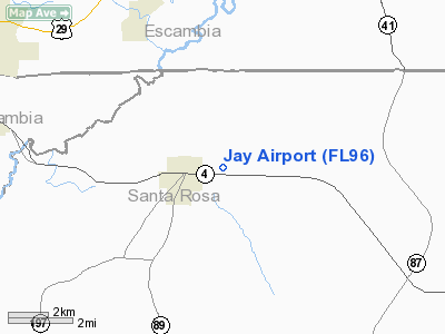
Location
& QuickFacts
|
FAA Information Effective: |
2007-01-18 |
|
Airport
Identifier: |
FL96 |
|
Airport
Status: |
Operational |
|
Longitude/Latitude: |
087-07-49.8900W/30-57-20.6590N
-87.130525/30.955739 (Estimated) |
|
Elevation: |
254 ft / 77.42 m (Surveyed) |
|
Land: |
0 acres |
|
From
nearest city: |
1 nautical miles E of Jay, FL |
|
Location: |
Santa Rosa County, FL |
|
Magnetic Variation: |
01E (1985) |
Owner
& Manager
|
Ownership: |
Privately owned |
|
Owner: |
Daniel E. Golden |
|
Address: |
6447 Dixonville Road
Jay, FL 32565 |
|
Phone number: |
850-675-4817 |
|
Manager: |
Daniel E. Golden |
|
Address: |
6447 Dixonville Road
Jay, FL 32565 |
|
Phone number: |
850-675-4817 |
Airport
Operations and Facilities
|
Airport Use: |
Private |
|
Wind indicator: |
Yes |
|
Segmented Circle: |
No |
|
Control Tower: |
No |
|
Landing fee charge: |
No |
|
Sectional chart: |
New Orleans |
|
Region: |
ASO - Southern |
|
Boundary ARTCC: |
ZJX - Jacksonville |
|
Tie-in FSS: |
GNV - Gainesville |
|
FSS on Airport: |
No |
|
FSS Phone: |
850-377-3291 |
|
FSS Toll Free: |
1-800-WX-BRIEF |
Airport
Services
|
Airframe Repair: |
NONE |
|
Power Plant Repair: |
NONE |
|
Bottled
Oxygen: |
NONE |
|
Bulk
Oxygen: |
NONE |
|
Runway Information
Runway 18/36
|
Dimension: |
2400 x 135 ft / 731.5 x 41.1 m |
|
Surface: |
TURF, |
|
|
Runway 18 |
Runway 36 |
|
Traffic
Pattern: |
Left |
Left |
|
Markings: |
None, |
None, |
|
Obstruction: |
60 ft trees, 1500.0 ft from runway, 50 ft left
of centerline, 25:1 slope to clear |
15 ft hgr, 60.0 ft from runway, 40 ft right
of centerline, 4:1 slope to clear |
|
Radio Navigation
Aids
|
ID |
Type |
Name |
Ch |
Freq |
Var |
Dist |
|
PKZ |
NDB |
Pickens |
|
326.00 |
01E |
31.3 nm |
|
ESU |
NDB |
Summerdale |
|
204.00 |
01E |
41.2 nm |
|
JUY |
NDB |
Judd |
|
264.00 |
02W |
43.5 nm |
|
DTS |
NDB |
Destin |
|
254.00 |
01W |
47.4 nm |
|
NSE |
TACAN |
Whiting |
070X |
|
01E |
15.1 nm |
|
NGS |
TACAN |
Santa Rosa |
063X |
|
01E |
22.8 nm |
|
NPA |
TACAN |
Pensacola |
119X |
|
01E |
37.2 nm |
|
HRT |
TACAN |
Hurlburt |
045X |
|
00E |
39.0 nm |
|
DWG |
TACAN |
Warrington |
002X |
|
00E |
42.6 nm |
|
NUN |
VOR |
Saufley |
|
108.80 |
01E |
30.9 nm |
|
UIA |
VOR |
Andalusia |
|
110.20 |
00E |
43.5 nm |
|
CEW |
VORTAC |
Crestview |
106X |
115.90 |
03E |
24.6 nm |
|
MVC |
VORTAC |
Monroeville |
115X |
116.80 |
04E |
32.4 nm |
Remarks
- RWY
36 HGR 60'/MOBILE HOME 150'/POLES 300' PAVED ROAD 310'/45' TOWERS 400'
FROM THR.
- OPERATIONS
MOSTLY CROP DUSTING.
- VFR
WEA CONDS.
Based Aircraft
|
Aircraft
based on field: |
2 |
|
Single
Engine Airplanes: |
2 |
Operational Statistics
Time Period: 1982-10-28
- 1983-10-27
|
Aircraft
Operations: |
60/Week |
|
General
Aviation Local: |
96.8% |
|
General
Aviation Itinerant: |
3.2% |
Jay Airport
Address:
Santa Rosa County, FL
Tel:
850-675-4817
Images
and information placed above are from
http://www.airport-data.com/airport/FL96/
We
thank them for the data!
| General
Info |
| Country |
United
States |
| State |
FLORIDA
|
| FAA ID |
FL96
|
| Latitude |
30-57-20.659N
|
| Longitude |
087-07-49.890W
|
| Elevation |
254 feet
|
| Near City |
JAY
|
We don't guarantee the information is fresh and accurate. The data may
be wrong or outdated.
For more up-to-date information please refer to other sources.
|
|


