 |
|
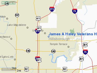
James A Haley Veterans Hospital Heliport |
Location
& QuickFacts
|
FAA Information Effective: |
2007-01-18 |
|
Airport
Identifier: |
70FL |
|
Airport
Status: |
Operational |
|
Longitude/Latitude: |
082-25-45.3300W/28-03-47.0600N
-82.429258/28.063072 (Estimated) |
|
Elevation: |
40 ft / 12.19 m (Estimated) |
|
Land: |
0 acres |
|
From
nearest city: |
0 nautical miles N of Tampa, FL |
|
Location: |
Hillsborough County, FL |
|
Magnetic Variation: |
02W (1985) |
Owner
& Manager
|
Ownership: |
Publicly owned |
|
Owner: |
James A Haley Veterans Hospital |
|
Address: |
13000 N. Bruce B. Downs Blvd
Tampa, FL 33612 |
|
Phone
number: |
813-972-7557 |
|
Manager: |
Jim Pirdlides |
|
Address: |
13000 N. Bruce B. Downs Blvd
Tampa, FL 33612 |
|
Phone number: |
813-972-7557 |
Airport
Operations and Facilities
|
Airport Use: |
Private
MEDICAL. |
|
Wind
indicator: |
Yes |
|
Segmented
Circle: |
No |
|
Control
Tower: |
No |
|
Sectional
chart: |
Jacksonville |
|
Region: |
ASO - Southern |
|
Boundary
ARTCC: |
ZJX - Jacksonville |
|
Tie-in
FSS: |
PIE - Saint Petersburg |
|
FSS
Toll Free: |
1-800-WX-BRIEF |
|
Runway Information
Helipad H1
|
Dimension: |
50 x 50 ft / 15.2 x 15.2 m |
|
Surface: |
CONC, Good Condition |
|
|
Runway H1 |
Runway |
|
Traffic
Pattern: |
Left |
Left |
|
Radio Navigation
Aids
|
ID |
Type |
Name |
Ch |
Freq |
Var |
Dist |
|
TPF |
NDB |
Knight |
|
270.00 |
02W |
9.4 nm |
|
AM |
NDB |
Picny |
|
388.00 |
02W |
13.6 nm |
|
PCM |
NDB |
Plant City |
|
346.00 |
02W |
14.9 nm |
|
RHZ |
NDB |
Zephyrhills |
|
253.00 |
03W |
17.5 nm |
|
CHN |
NDB |
Wauchula |
|
261.00 |
04W |
44.1 nm |
|
MCF |
TACAN |
Macdill |
047X |
|
04W |
12.9 nm |
|
PIE |
VORTAC |
St Petersburg |
111X |
116.40 |
01E |
16.4 nm |
|
LAL |
VORTAC |
Lakeland |
107X |
116.00 |
01E |
22.5 nm |
|
SRQ |
VORTAC |
Sarasota |
099X |
115.20 |
02W |
40.5 nm |
|
TPA |
VOT |
Tampa Intl |
|
111.00 |
|
7.7 nm |
Remarks
- SEE
AIRSPACE CASE 97-ORL-020-NRA.
James A Haley Veterans Hospital Heliport
Address:
Hillsborough County, FL
Tel:
813-972-7557
Images
and information placed above are from
http://www.airport-data.com/airport/70FL/
We
thank them for the data!
| General
Info |
| Country |
United
States |
| State |
FLORIDA
|
| FAA ID |
70FL
|
| Latitude |
28-03-47.060N
|
| Longitude |
082-25-45.330W
|
| Elevation |
40 feet
|
| Near City |
TAMPA
|
We don't guarantee the information is fresh and accurate. The data may
be wrong or outdated.
For more up-to-date information please refer to other sources.
|
|


