 |
|
Coordinates: 26°25′59.40″N 081°24′03.70″W / 26.433167°N 81.401028°W / 26.433167; -81.401028
| Immokalee Airport |
 |
| 14 February 1999 |
| IATA: IMM – ICAO: KIMM – FAA LID: IMM |
| Summary |
| Airport type |
Public use |
| Owner |
Collier County, Florida |
| Operator |
Jim Kenney |
| Serves |
Immokalee, Florida |
| Location |
Collier County, Florida |
| Elevation AMSL |
36 ft / 11 m |
| Runways |
| Direction |
Length |
Surface |
| ft |
m |
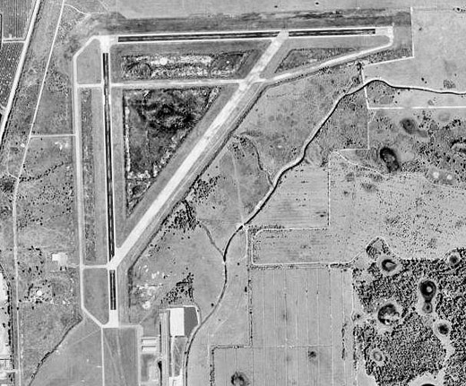
| 9/27 |
5,000 |
1,524 |
Asphalt |
| 18/36 |
5,000 |
1,524 |
Asphalt |
| Statistics (1999) |
| Aircraft operations |
18,980 |
| Based aircraft |
59 |
| Source: Federal Aviation Administration |
Immokalee Airport (IATA: IMM, ICAO: KIMM, FAA LID: IMM) is a public-use airport located 1 mile (1.6 km) northeast of the central business district of Immokalee in Collier County, Florida, United States. The airport is publicly owned. History
Established as Immokalee Army Airfield, activated on 5 July 1942. Assigned to United States Army Air Forces East Coast Training Center (later Eastern Training Command). Was an auxiliary to Hendricks Army Airfield and was an AAF Specialized Pilot Training School (4-Engine) for B-17 and B-24 heavy bombers. Also provided flexible gunnery training.
Transferred to Third Air Force in July 1944 with the drawdown of AAFTC's pilot training program and was a group training facility for replacement personnel. Became an auxiliary of the Sarasota Army Airfield replacement fighter pilot training school. Declared surplus and turned over to the Army Corps of Engineers on 30 September 1945. Eventually discharged to the War Assets Administration (WAA) and became civil airport.
The above content comes from Wikipedia and is published under free licenses – click here to read more.

Location
& QuickFacts
|
FAA Information Effective: |
2007-01-18 |
|
Airport
Identifier: |
IMM |
|
Airport
Status: |
Operational |
|
Longitude/Latitude: |
081-24-03.7000W/26-25-59.4000N
-81.401028/26.433167 (Estimated) |
|
Elevation: |
36 ft / 10.97 m (Surveyed) |
|
Land: |
1330 acres |
|
From
nearest city: |
1 nautical miles NE of Immokalee, FL |
|
Location: |
Collier County, FL |
|
Magnetic Variation: |
02W (1985) |
Owner
& Manager
|
Ownership: |
Publicly owned |
|
Owner: |
Collier County |
|
Address: |
2003 Mainsail Drive
Naples, FL 34114 |
|
Phone number: |
863-642-7878 |
|
Manager: |
John Kirchner |
|
Address: |
165 Airpark Blvd
Immokalee, FL 34142 |
|
Phone number: |
863-657-9003 |
Airport
Operations and Facilities
|
Airport Use: |
Open to public |
|
Wind
indicator: |
Yes |
|
Segmented
Circle: |
Yes |
|
Control
Tower: |
No |
|
Lighting
Schedule: |
DUSK-DAWN
ACTVT MIRL RY 09/27 & HIRL RY 18/36 - CTAF. |
|
Beacon
Color: |
Clear-Green (lighted land airport) |
|
Landing
fee charge: |
No |
|
Sectional
chart: |
Miami |
|
Region: |
ASO - Southern |
|
Boundary
ARTCC: |
ZMA - Miami |
|
Tie-in
FSS: |
MIA - Miami |
|
FSS
on Airport: |
No |
|
FSS
Phone: |
305-233-2600 |
|
FSS
Toll Free: |
1-800-WX-BRIEF |
|
NOTAMs
Facility: |
MIA (NOTAM-d service avaliable) |
|
Federal Agreements: |
NGPY |
Airport
Communications
Airport
Services
|
Fuel available: |
100LLA
FUEL AVBL 24 HRS BY CREDIT CARD. |
|
Airframe Repair: |
MINOR |
|
Power Plant Repair: |
MINOR |
|
Bottled
Oxygen: |
NONE |
|
Bulk
Oxygen: |
NONE |
|
Runway Information
Runway 09/27
|
Dimension: |
5000 x 150 ft / 1524.0 x 45.7 m |
|
Surface: |
ASPH, Good Condition |
|
Weight
Limit: |
Single wheel: 35000 lbs.
Dual wheel: 60000 lbs.
Dual
tandem wheel: 110000 lbs. |
|
Edge
Lights: |
Medium |
|
|
Runway 09 |
Runway 27 |
|
Longitude: |
081-24-19.5740W |
081-23-24.6000W |
|
Latitude: |
26-26-13.3220N |
26-26-15.0250N |
|
Elevation: |
35.00 ft |
33.00 ft |
|
Alignment: |
88 |
127 |
|
Traffic
Pattern: |
Left |
Left |
|
Markings: |
Basic, Good Condition |
Basic, Good Condition |
|
Obstruction: |
11 ft brush, 600.0 ft from runway, 36:1 slope
to clear |
4 ft fence, 320.0 ft from runway, 30:1 slope
to clear |
|
Runway 18/36
|
Dimension: |
5000 x 150 ft / 1524.0 x 45.7 m |
|
Surface: |
ASPH, Good Condition |
|
Weight
Limit: |
Single wheel: 35000 lbs.
Dual wheel: 60000 lbs.
Dual
tandem wheel: 110000 lbs. |
|
Edge
Lights: |
High |
|
|
Runway 18 |
Runway 36 |
|
Longitude: |
081-24-18.7790W |
081-24-16.8800W |
|
Latitude: |
26-26-14.0900N |
26-25-24.5990N |
|
Elevation: |
36.00 ft |
33.00 ft |
|
Alignment: |
127 |
127 |
|
Traffic
Pattern: |
Left |
Left |
|
Markings: |
Non-precision instrument, Good Condition |
Basic, Good Condition |
|
Obstruction: |
4 ft fence, 410.0 ft from runway, 50:1 slope
to clear |
30 ft pline, 2046.0 ft from runway, 50:1 slope
to clear |
|
Radio Navigation
Aids
|
ID |
Type |
Name |
Ch |
Freq |
Var |
Dist |
|
APF |
NDB |
Naples |
|
201.00 |
03W |
26.1 nm |
|
PGD |
VOR |
Punta Gorda |
|
110.20 |
03W |
43.0 nm |
|
CYY |
VOR/DME |
Cypress |
023X |
108.60 |
03W |
26.4 nm |
|
RSW |
VORTAC |
Lee County |
055X |
111.80 |
02W |
21.0 nm |
|
LBV |
VORTAC |
La Belle |
041X |
110.40 |
01E |
23.7 nm |
|
PHK |
VORTAC |
Pahokee |
101X |
115.40 |
00E |
43.5 nm |
Remarks
- CROP
DUSTING OPNS CONDUCTED DURING DALGT HRS.
- TAKE-OFFS
AND LANDINGS ON TURF AREAS OF ARPT ARE DONE SO AT PILOTS OWN RISK AND
RESPONSIBILITY.
- REFLECTORS
ON TWYS A, B, C LGTD.
- PCL
OTS INDEFLY.
- GLIDER
ACTIVITY BLO 10,000 FT 10 NM RADIUS FROM SR-SS.
- VFR
ONLY
Based Aircraft
|
Aircraft
based on field: |
59 |
|
Single
Engine Airplanes: |
51 |
|
Multi
Engine Airplanes: |
3 |
|
Jet Engine
Airplanes: |
2 |
|
Helicopters: |
3 |
Operational Statistics
Time Period: 1998-08-26
- 1999-08-25
|
Aircraft
Operations: |
52/Day |
|
General
Aviation Local: |
76.9% |
|
General
Aviation Itinerant: |
23.1% |
Immokalee Airport
Address:
Collier County, FL
Tel:
863-642-7878, 863-657-9003
Images
and information placed above are from
http://www.airport-data.com/airport/IMM/
We
thank them for the data!
| General
Info |
| Country |
United
States |
| State |
FLORIDA
|
| FAA ID |
IMM
|
| Latitude |
26-25-59.400N
|
| Longitude |
081-24-03.700W
|
| Elevation |
36 feet
|
| Near City |
IMMOKALEE
|
We don't guarantee the information is fresh and accurate. The data may
be wrong or outdated.
For more up-to-date information please refer to other sources.
|
|


