Hernando County Airport in Florida Florida airports - Hernando County Airport
Hernando County Airport in Florida - United States
Florida Airports
USA Airports
World Airports
Airport photos - free!
Aircraft photos - free!
Spacecraft pics - free!
Aviation Articles

Hernando County Airport


Hernando County Airport
USGS aerial image, 31 December 1998
IATA: none – ICAO: KBKV – FAA LID: BKV
Summary
Airport type Public
Owner Hernando County
Location Hernando County, near Brooksville, Florida
Elevation AMSL 76 ft / 23 m
Coordinates 28°28′25″N 082°27′20″W / 28.47361°N 82.45556°W / 28.47361; -82.45556
Website www.flyhernando.com/
Runways
Direction Length Surface
ft m
3/21 5,015 1,529 Concrete
9/27 7,002 2,134 Concrete
Statistics (2001)
Aircraft operations 49,000
Based aircraft 108
Source: Federal Aviation Administration


Emblem of Air University

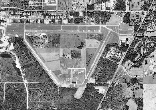
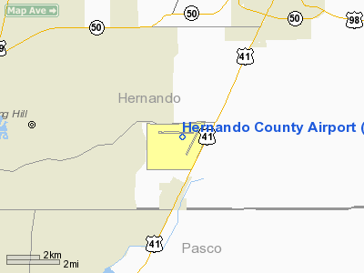
Hernando County Airport (ICAO: KBKV, FAA LID: BKV) is a joint civil-military public airport located 6 nautical miles (11 km) southwest of the central business district of Brooksville, a city in Hernando County, Florida, United States. It is owned by Hernando County and is 45 miles (72 km) north of Tampa. While having consistent growth in its traffic rate, the Hernando County Airport does not yet serve the public through commercial airlines, but does have charter and executive service.

Although most U.S. airports use the same three-letter location identifier for the FAA and IATA, Hernando County Airport is assigned BKV by the FAA but has no designation from the IATA.

History

Hernando County Airport was opened in November 1942 by the United States Army Air Forces. Known as Brooksville Army Airfield, it was used as part of the Air University's Army Air Forces School of Applied Tactics (AAFSAT) tactical combat simulation school in Central and Northern Florida.

Headquartered at Orlando Army Air Base, AAFSAT's mission was to develop tactics and techniques of aerial warfare and to establish technical and tactical proficiency requirements for combat units to effectively engage and defeat enemy air forces. This was done with a wide variety of aircraft, including heavy strategic bombers, tactical fighters, medium and light bombers, reconnaissance aircraft and dive bombers, based at different airfields of the school.

AAFSAT used Brooksville as a heavy and medium bomber training base, assigning the following squadrons to the airfield:

  • 1st Bombardment Squadron, 15 December 1942-25 February 1944 (B-17 Flying Fortress)
  • 5th Bombardment Squadron, 6 January-25 February 1944, (B-24 Liberator), (B-25 Mitchell)
  • 99th Bombardment Squadron, 5 January-25 February 1944 (B-25 Mitchell), (B-26 Marauder)
  • 430th Bombardment Squadron, 6 January-25 February 1944 (B-24 Liberator), (B-25 Mitchell), (B-26 Marauder)

In March 1944, Brooksville was reassigned to Third Air Force and it became an auxiliary airfield of MacDill Field (now MacDill AFB) and Drew Field (now Tampa International Airport).

In late 1945, the field was reported to the War Assets Administration (WAA) as being in surplus and between April 1946 and June 1947, the WAA sold or moved the on-site equipment to military locations where it could be better utilized. The land and left-over facilities were sold to the city of Brooksville by a General Services Administration (GSA) quitclaim deeds which contained clauses that limited the property to be used for a public airport only. Some of these clauses have since been modified by the Federal Aviation Administration.

Within a few years, the city of Brooksville transferred the property to Hernando County, which remains the current owner. Two small sections of the land have been sold to private interests and the rest is currently used by the county for an airport, 155-acre (0.63 km) industrial park, prison, land rentals, and tree farming.

Army National Guard

Since 2000, the Hernando County Airport has been a joint civil-military airfield, home to the Florida Army National Guard's Army Aviation Support Facility #2 and the Florida Army National Guard's 171st Aviation Battalion (171 AVN BN), which reloacted from their previous facility at Lakeland Linder Regional Airport, occupying newly constructed facilities adjacent to an existing Florida Army National Guard Armory housing the 3rd Battalion, 20th Special Forces. The 171 AVN BN flies UH-60 Blackhawk helicopters and C-23 Sherpa fixed-wing cargo aircraft.

Facilities and aircraft

Hernando County Airport covers an area of 2,498 acres (1,011 ha) which contains two concrete paved runways: 9/27 measuring 7,002 x 150 ft (2,134 x 46 m) and 3/21 measuring 5,015 x 150 ft (1,529 x 46 m).

For the 12-month period ending November 7, 2001, the airport had 49,000 aircraft operations, an average of 134 per day: 98% general aviation, 1% military and 1% air taxi. There are 108 aircraft based at this airport: 83% single engine, 7% multi-engine, 5% helicopters, 3% ultralights and 2% jet aircraft.


The above content comes from Wikipedia and is published under free licenses – click here to read more.

Hernando County Airport picture

Location & QuickFacts

FAA Information Effective:

2007-01-18

Airport Identifier:

BKV

Airport Status:

Operational

Longitude/Latitude:

082-27-19.5170W/28-28-24.9500N
-82.455421/28.473597 (Estimated)

Elevation:

77 ft / 23.47 m (Surveyed)

Land:

2498 acres

From nearest city:

6 nautical miles SW of Brooksville, FL

Location:

Hernando County, FL

Magnetic Variation:

04W (2000)

Owner & Manager

Ownership:

Publicly owned

Owner:

Hernando County

Address:

16110 Aviation Loop Dr
Brooksville, FL 34609

Phone number:

352-754-4061

Manager:

Bob Mattingly
ARPT ADMINISTRATOR.

Address:

16110 Aviation Loop Dr
Brooksville, FL 34609

Phone number:

352-754-4061

Airport Operations and Facilities

Airport Use:

Open to public

Wind indicator:

Yes

Segmented Circle:

Yes

Control Tower:

No

Lighting Schedule:

DUSK-DAWN
MIRL RYS 03/21 & 09/27 PRESET LOW INTST DUSK-2200, TO INCR INTST AND ACTVT AFTER 2200 - CTAF.
ACTVT PAPI RYS 09 & 27 - CTAF.

Beacon Color:

Clear-Green (lighted land airport)

Landing fee charge:

No

Sectional chart:

Jacksonville

Region:

ASO - Southern

Boundary ARTCC:

ZJX - Jacksonville

Responsible ARTCC:

ZMA - Miami

Tie-in FSS:

PIE - Saint Petersburg

FSS on Airport:

No

FSS Toll Free:

1-800-WX-BRIEF

NOTAMs Facility:

BKV (NOTAM-d service avaliable)

Federal Agreements:

NGPRY

Airport Communications

CTAF:

123.000

Unicom:

123.000 

Airport Services

Fuel available:

100LLA

Airframe Repair:

MAJOR

Power Plant Repair:

MAJOR

Bottled Oxygen:

HIGH

Bulk Oxygen:

HIGH

Runway Information

Runway 03/21

Dimension:

5015 x 150 ft / 1528.6 x 45.7 m

Surface:

CONC, Good Condition

Weight Limit:

Single wheel: 50000 lbs.
Dual wheel: 75000 lbs.
Dual tandem wheel: 135000 lbs.

Edge Lights:

Medium


Runway 03

Runway 21

Longitude:

082-27-10.2710W

082-26-45.5710W

Latitude:

28-27-50.8640N

28-28-35.4650N

Elevation:

68.00 ft

69.00 ft

Alignment:

26

127

Traffic Pattern:

Left

Left

Markings:

Non-precision instrument, Good Condition

Non-precision instrument, Good Condition

Obstruction:

44 ft trees, 2150.0 ft from runway, 44:1 slope to clear

50 ft trees, 1900.0 ft from runway, 34:1 slope to clear


Runway 09/27

Dimension:

7001 x 150 ft / 2133.9 x 45.7 m

Surface:

CONC, Good Condition

Weight Limit:

Single wheel: 90000 lbs.
Dual wheel: 130000 lbs.
Dual tandem wheel: 230000 lbs.

Edge Lights:

Medium


Runway 09

Runway 27

Longitude:

082-28-14.2120W

082-26-55.7630W

Latitude:

28-28-33.2730N

28-28-33.5080N

Elevation:

71.00 ft

70.00 ft

Alignment:

90

127

ILS Type:

ILS


Traffic Pattern:

Left

Left

Markings:

Precision instrument, Good Condition

Non-precision instrument, Good Condition

VASI:

4-light PAPI on left side

4-light PAPI on left side

Approach lights:

MALSR


Obstruction:

, 50:1 slope to clear

55 ft trees, 2400.0 ft from runway, 40:1 slope to clear


Radio Navigation Aids

ID

Type

Name

Ch

Freq

Var

Dist

RHZ

NDB

Zephyrhills


253.00

03W

21.6 nm

PCM

NDB

Plant City


346.00

02W

32.4 nm

TPF

NDB

Knight


270.00

02W

34.0 nm

AM

NDB

Picny


388.00

02W

37.1 nm

LEE

NDB

Leesburg


335.00

04W

40.0 nm

MCF

TACAN

Macdill

047X


04W

36.9 nm

PIE

VORTAC

St Petersburg

111X

116.40

01E

36.1 nm

LAL

VORTAC

Lakeland

107X

116.00

01E

37.5 nm

OCF

VORTAC

Ocala

084X

113.70

00E

44.0 nm

TPA

VOT

Tampa Intl


111.00


30.3 nm

 Based Aircraft

Aircraft based on field:

108

Single Engine Airplanes:

90

Multi Engine Airplanes:

8

Jet Engine Airplanes:

2

Helicopters:

5

Ultralights:

3

Operational Statistics

    Time Period: 2000-11-08 - 2001-11-07

Aircraft Operations:

135/Day

Air Taxi:

0.6%

General Aviation Local:

53.5%

General Aviation Itinerant:

44.9%

Military:

1.0%


Hernando County Airport   

Address: Hernando County, FL

Tel: 352-754-4061


Images and information placed above are from
http://www.airport-data.com/airport/BKV/

We thank them for the data!


General Info
Country United States
State FLORIDA
FAA ID BKV
Latitude 28-28-24.950N
Longitude 082-27-19.517W
Elevation 77 feet
Near City BROOKSVILLE


We don't guarantee the information is fresh and accurate. The data may be wrong or outdated.
For more up-to-date information please refer to other sources.


christianity portal
directory of hotels worldwide


Copyright 2004-2024 © by Airports-Worldwide.com, Vyshenskoho st. 36, Lviv 79010, Ukraine
Legal Disclaimer