|
|
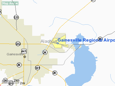
Gainesville Regional Airport |
Coordinates: 29°41′24″N 082°16′18″W / 29.69°N 82.27167°W / 29.69; -82.27167
| Gainesville Regional Airport |
 |
| IATA: GNV – ICAO: KGNV – FAA LID: GNV |
| Summary |
| Airport type |
Public |
| Owner |
Gainesville-Alachua County Authority |
| Location |
Gainesville, Florida |
| Elevation AMSL |
152 ft / 46 m |
| Website |
www.gra-gnv.com |
| Runways |
| Direction |
Length |
Surface |
| ft |
m |
| 11/29 |
7,504 |
2,287 |
Asphalt |
| 7/25 |
4,158 |
1,267 |
Asphalt |
| Statistics (2006) |
| Aircraft operations |
133,881 |
| Based aircraft |
131 |
| Source: Federal Aviation Administration |
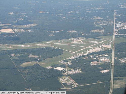
Gainesville Regional Airport (IATA: GNV, ICAO: KGNV, FAA LID: GNV) is a public airport located three miles (5 km) northeast of the central business district of Gainesville, a city in Alachua County, Florida, United States. The airport is owned by the City of Gainesville, FL and operated by the Gainesville-Alachua County Regional Airport Authority. It was formerly known as J.R. Alison Airport.
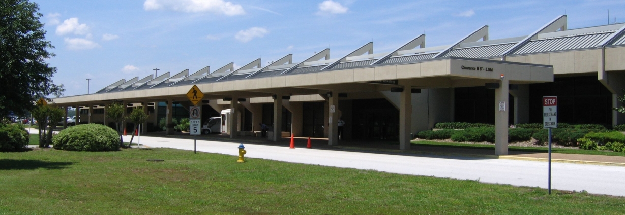
Within recent years, the Airport has undertaken and substantially completed several large-scale projects that include the refurbishment of its primary runway (11/29), piping of an open ditch parallel to that runway, and completion of Phase 1 of the Terminal Renovation project. Three passenger boarding bridges, covered walkways that connect the terminal building to the aircraft, have been installed, and the Authority has commissioned the design of Phase 2 of the Terminal Renovation. Eclipse Aviation, maker of the Eclipse 500, operated its first factory service center in Gainesville until the company declared bankruptcy in 2009. The airport operates a control tower during daylight hours and is in Class D airspace during that time. Facilities and aircraft
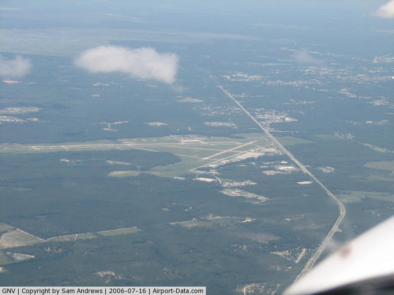
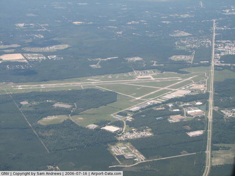
Gainesville Regional Airport covers an area of 1,650 acres (668 ha) which contains two asphalt paved runways: 11/29 measuring 7,504 x 150 ft (2,287 x 46 m) and 7/25 measuring 4,158 x 100 ft (1,267 x 30 m).
For the 12-month period ending December 31, 2006, the airport had 133,881 aircraft operations, an average of 366 per day: 84% general aviation, 8% air taxi, 7% military and 1% scheduled commercial. There are 131 aircraft based at this airport: 83% single-engine, 9% multi-engine, 4% jet and 4% helicopter.
Gainesville regional airport is served by one FBO, University Air Center. Previously there were two, Gulf Atlantic Airways and Flight Line. Flight Line's contract with the airport authority expired and Gulf Atlantic became University Air Center. University Air Center provides a pilots lounge with TV, snack machines, aircraft rentals and charters, and fuel.
Airlines and destinations
 | |
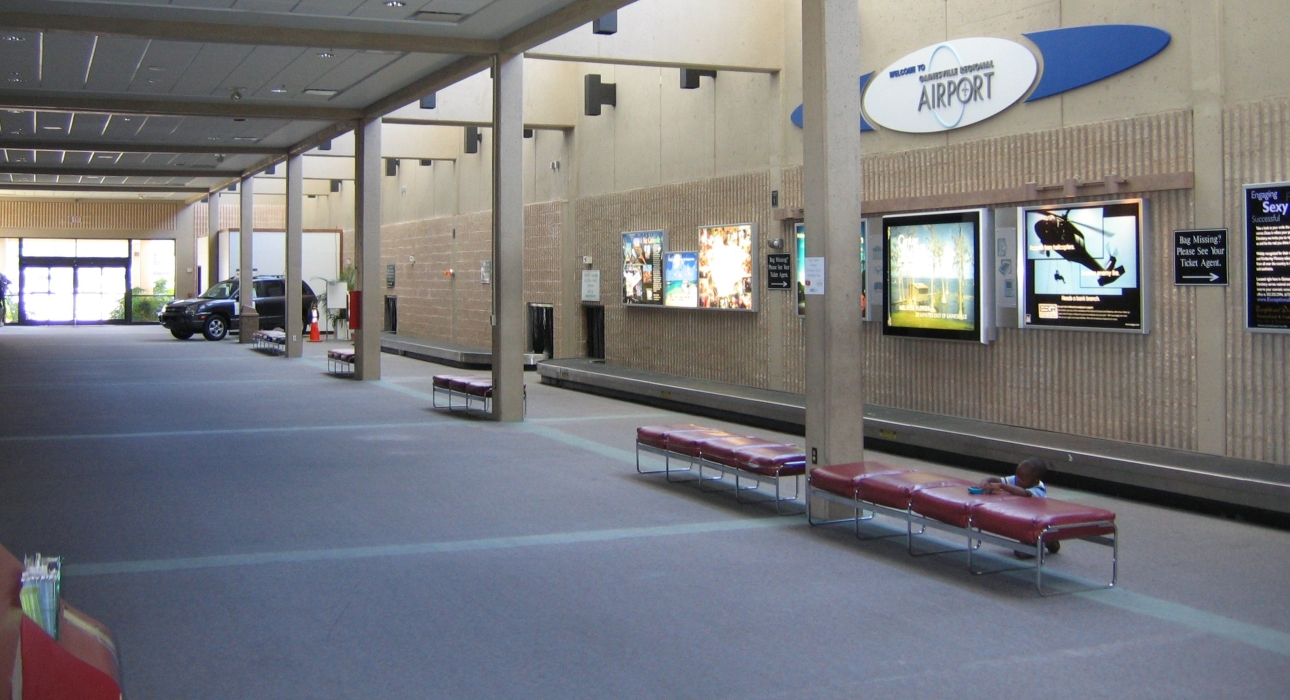
Airport Interior, West Lobby |
| Airlines |
Destinations |
| American Eagle operated by Executive Airlines |
Miami |
| Delta Connection operated by Atlantic Southeast Airlines |
Atlanta |
| US Airways Express operated by PSA Airlines |
Charlotte |
HistoryConstruction of the airport began in April 1940 as a Works Project Administration project. In 1941 initial construction was completed. Upon conclusion of the construction by the United States Army Corps of Engineers, the facility was known as the Alachua Army Airfield and was used by the Army Air Corps and the Army Air Forces.
On 2 March 1942, the Gainesville City Council established the name of the airfield as the John R. Alison Airport. John R. Alison was a local citizen and graduate of the University of Florida who served with valor and distinction in World War II. He was selected to serve as an observer in England and later served in Russia training Russian flyers.
Alachua AAF was assigned to the Air University Army Air Forces School of Applied Tactics (AAFSAT) tactical combat simulation school in Central and Northern Florida.
Headquartered at Orlando Army Air Base, the school's mission was to develop tactics and techniques of aerial warfare and to establish technical and tactical proficiency requirements for combat units to effectively engage and defeat enemy air forces. This was done with a wide variety of aircraft, including heavy strategic bombers; tactical fighters; medium and light bombers; reconnaissance and dive bombers, based at different airfields of the school.
Squadrons assigned by the AAFSAT were:
- 465th Bombardment Squadron, 24 January-19 November 1943, (DB-7 (A-20) Havoc)
- 667th Bombardment Squadron (Dive)/521st Fighter Squadron, 15 February 1943-2 March 1944 (A-24 Dauntless), (P-39 Aircobra), (A-36 Apache)
In mid-1943, Third Air Force at Drew Field near Tampa began using Alachua as a group training base, assigning several air commando fighter squadrons to the airfield for training prior to their deployment to the China-Burma-India theater:
- 1st Fighter (Commando) Squadron, 21 June-17 August 1944 (P-51 Mustang)
- 2d Fighter (Commando) Squadron, 21 June-17 August 1944 (P-51 Mustang)
- 3d Fighter (Commando) Squadron, 6–24 October 1944 (P-51 Mustang)
- 4th Fighter (Commando) Squadron, 21 August-6 October October 1944 (P-51 Mustang)
- 317th Troop Carrier (Commando) Squadron, 7–21 June 1944 (C-47 Skytrain)
At the end of the war, the airfield was declared surplus in September 1945 and turned over to the Army Corps of Engineers on 1 October 1946. The War Assets Administration deeded the facility to the city of Gainesville in 1948 as a civil airport. At that time, the field was known as the John R. Alison Airport and also as the Gainesville Municipal Airport. The city operated, maintained, and improved the airport over the years as the Gainesville Municipal Airport.
In order to recognize the role the airport carries in meeting the regional demands for aviation services, the airport was renamed the Gainesville Regional Airport in October 1977. The airline passenger terminal was dedicated to John R. Alison in 1979.
In 1986, the State Legislature passed a bill that established the Airport as the Gainesville-Alachua County Regional Airport Authority. The Airport Authority, which consists of nine board members, five selected by the City of Gainesville, three by the Governor and one by Alachua County, continues to oversee the Airport to date.
The above content comes from Wikipedia and is published under free licenses – click here to read more.
|
 |
(Click on the photo to enlarge) |
|
 |
(Click on the photo to enlarge) |
Location
& QuickFacts
|
FAA Information Effective: |
2007-01-18 |
|
Airport
Identifier: |
GNV |
|
Airport
Status: |
Operational |
|
Longitude/Latitude: |
082-16-18.4000W/29-41-24.2000N
-82.271778/29.690056 (Estimated) |
|
Elevation: |
152 ft / 46.33 m (Surveyed) |
|
Land: |
1650 acres |
|
From
nearest city: |
3 nautical miles NE of Gainesville, FL |
|
Location: |
Alachua County, FL |
|
Magnetic Variation: |
03W (1985) |
Owner
& Manager
|
Ownership: |
Publicly owned |
|
Owner: |
Gainesville-alchua Co Auth
GAINESVILLE-ALCHUA CO REGIONAL ARPT AUTHORITY |
|
Address: |
3880 Ne 39th Ave
Gainesville, FL 32609 |
|
Phone
number: |
352-373-0249 |
|
Manager: |
Richard Crider |
|
Address: |
3880 Ne 39 Ave Ste A
Gainesville, FL 32609 |
|
Phone number: |
352-373-0249 |
Airport
Operations and Facilities
|
Airport Use: |
Open to public |
|
Wind
indicator: |
Yes |
|
Segmented
Circle: |
Yes |
|
Control
Tower: |
Yes |
|
Lighting
Schedule: |
DUSK-DAWN
WHEN ATCT CLSD; ACTVT MIRL RY 07/25, HIRL RY 11/29 AND MALSR
RY 29 - CTAF. |
|
Beacon
Color: |
Clear-Green (lighted land airport) |
|
Landing
fee charge: |
No |
|
Sectional
chart: |
Jacksonville |
|
Region: |
ASO - Southern |
|
Boundary
ARTCC: |
ZJX - Jacksonville |
|
Tie-in
FSS: |
GNV - Gainesville |
|
FSS
on Airport: |
Yes |
|
FSS
Phone: |
850-377-3291 |
|
FSS
Toll Free: |
1-800-WX-BRIEF |
|
NOTAMs
Facility: |
GNV (NOTAM-d service avaliable) |
|
Certification
type/date: |
I B S 12/2004
CLSD TO UNSKED ACR OPNS WITH MORE THAN 30 PSGR SEATS EXCP
WITH 24 HR PPR CALL AMGR 352-373-0249. |
|
Federal Agreements: |
NGPY3 |
Airport
Communications
|
CTAF: |
119.550 |
|
Unicom: |
122.950 |
Airport
Services
|
Fuel available: |
100 A |
|
Airframe Repair: |
MAJOR |
|
Power Plant Repair: |
MAJOR |
|
Bottled
Oxygen: |
HIGH |
|
Bulk
Oxygen: |
HIGH |
|
Runway Information
Runway 07/25
|
Dimension: |
4158 x 100 ft / 1267.4 x 30.5 m |
|
Surface: |
ASPH, Good Condition |
|
Surface
Treatment: |
Saw-cut or plastic Grooved
STD GROOVING FULL LENGTH AND 110 FT WIDE CENTER PORTION. |
|
Weight
Limit: |
Single wheel: 75000 lbs.
Dual wheel: 150000 lbs.
Dual
tandem wheel: 210000 lbs. |
|
Edge
Lights: |
Medium |
|
|
Runway 07 |
Runway 25 |
|
Longitude: |
082-16-56.6093W |
082-16-15.3662W |
|
Latitude: |
29-41-25.1016N |
29-41-45.0378N |
|
Elevation: |
152.00 ft |
130.00 ft |
|
Alignment: |
61 |
127 |
|
Traffic
Pattern: |
Left |
Left |
|
Markings: |
Non-precision instrument, Good Condition |
Non-precision instrument, Good Condition |
|
Crossing
Height: |
40.00 ft |
40.00 ft |
|
VASI: |
4-light PAPI on left side |
4-light PAPI on left side |
|
Visual
Glide Angle: |
3.00� |
3.00� |
|
Runway
End Identifier: |
No |
|
|
Obstruction: |
92 ft trees, 2500.0 ft from runway, 500 ft
left of centerline, 25:1 slope to clear |
, 50:1 slope to clear |
|
Runway 11/29
|
Dimension: |
7504 x 150 ft / 2287.2 x 45.7 m |
|
Surface: |
ASPH, Good Condition |
|
Surface
Treatment: |
Saw-cut or plastic Grooved
STD GROOVING FULL LENGTH AND 110 FT WIDE CENTER PORTION. |
|
Weight
Limit: |
Single wheel: 75000 lbs.
Dual wheel: 260000 lbs.
Dual
tandem wheel: 320000 lbs. |
|
Edge
Lights: |
High |
|
|
Runway 11 |
Runway 29 |
|
Longitude: |
082-16-50.1553W |
082-15-27.0278W |
|
Latitude: |
29-41-26.0068N |
29-41-10.2138N |
|
Elevation: |
147.00 ft |
105.00 ft |
|
Alignment: |
102 |
127 |
|
ILS
Type: |
|
ILS |
|
Traffic
Pattern: |
Left |
Left |
|
Markings: |
Precision instrument, Good Condition
RY 11 MARKINGS FADED |
Precision instrument, Good Condition
RY 29 MARKINGS FADED. |
|
Crossing
Height: |
50.00 ft |
50.00 ft |
|
VASI: |
4-light PAPI on left side |
4-light PAPI on left side |
|
Visual
Glide Angle: |
0.00� |
3.00� |
|
RVR
Equipment: |
rollout |
touchdown |
|
Approach
lights: |
|
MALSR |
|
Runway
End Identifier: |
Yes |
|
|
Radio Navigation
Aids
|
ID |
Type |
Name |
Ch |
Freq |
Var |
Dist |
|
GN |
NDB |
Wynds |
|
269.00 |
04W |
5.3 nm |
|
IAK |
NDB |
Palatka |
|
243.00 |
05W |
24.1 nm |
|
LCQ |
NDB |
Lake City |
|
204.00 |
03W |
33.8 nm |
|
HEG |
NDB |
Herlong |
|
332.00 |
02W |
42.7 nm |
|
NZC |
TACAN |
Cecil/dcmsnd |
088X |
|
04W |
38.1 nm |
|
NIP |
TACAN |
Jacksonville |
19X |
|
04W |
45.1 nm |
|
VQQ |
VOR |
Cecil |
|
117.90 |
03W |
37.2 nm |
|
GNV |
VORTAC |
Gators |
109X |
116.20 |
04W |
0.1 nm |
|
OCF |
VORTAC |
Ocala |
084X |
113.70 |
00E |
30.9 nm |
|
CTY |
VORTAC |
Cross City |
057X |
112.00 |
02W |
41.0 nm |
Remarks
- WHEN
ATCT CLSD ACFT WEIGHING MORE THAN 12500 LBS ARE REQUIRED TO CTC FBO
OPNS FOR PARKING INSTRUCTIONS PRIOR TO EXITING TWY 'A' DUE TO IREG PAVEMENT
STRENGTHS.
- A
SMALL PORTION OF RY 06/24 AND TWY 'A' IS NOT VISIBLE FROM THE ATCT BECAUSE
THE LINE OF SIGHT IS BLOCKED BY THE VORTAC BLDG.
- NORTHEAST
1000 FT PORTION OF TWY 'A' IS NOT VISIBLE FROM THE ATCT.
- RY
07/25 NOT AVBL TO ACR ACFT.
Based Aircraft
|
Aircraft
based on field: |
134 |
|
Single
Engine Airplanes: |
106 |
|
Multi
Engine Airplanes: |
16 |
|
Jet Engine
Airplanes: |
6 |
|
Helicopters: |
6 |
Major Carriers
Serving This Airport
| Atlantic Southeast Airlines |
100.0% |
Most Popular Destinations
|
Hartsfield - Jackson Atlanta Intl (ATL) |
100.0% |
Most Popular Aircraft
|
N634AS |
3.2% |
| N643AS |
2.7% |
|
N632AS |
2.5% |
| N636AS |
2.3% |
|
N637AS |
2.0% |
| N633AS |
2.0% |
|
N640AS |
2.0% |
| N642AS |
1.8% |
|
N821AS |
1.8% |
| N635AS |
1.8% |
Operational Statistics
Time Period: 2005-01-01
- 2005-12-31
|
Aircraft
Operations: |
213/Day |
|
Commerical: |
3.1% |
|
Air Taxi: |
2.9% |
|
General
Aviation Local: |
30.5% |
|
General
Aviation Itinerant: |
52.6% |
|
Military: |
11.0% |
Gainesville Regional Airport
Address:
Alachua County, FL
Tel:
352-373-0249
Images
and information placed above are from
http://www.airport-data.com/airport/GNV/
We
thank them for the data!
| General
Info |
| Country |
United
States |
| State |
FLORIDA
|
| FAA ID |
GNV
|
| Latitude |
29-41-24.200N
|
| Longitude |
082-16-18.400W
|
| Elevation |
152 feet
|
| Near City |
GAINESVILLE
|
We don't guarantee the information is fresh and accurate. The data may
be wrong or outdated.
For more up-to-date information please refer to other sources.
|
|