 |
|
Flying Henderson Heliport |
Location
& QuickFacts
|
FAA Information Effective: |
2007-01-18 |
|
Airport
Identifier: |
81FD |
|
Airport
Status: |
Operational |
|
Longitude/Latitude: |
080-11-59.1620W/26-55-02.2080N
-80.199767/26.917280 (Estimated) |
|
Elevation: |
18 ft / 5.49 m (Estimated) |
|
Land: |
0 acres |
|
From
nearest city: |
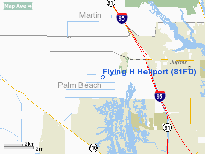
5 nautical miles W of Jupiter, FL |
|
Location: |
Palm Beach County, FL |
|
Magnetic Variation: |
04W (1990) |
Owner
& Manager
|
Ownership: |
Privately owned |
|
Owner: |
Flying H Ranch |
|
Address: |
10094 165th St.
Jupiter, FL 33458 |
|
Phone
number: |
407-747-3500 |
|
Manager: |
Christopher T. Henderson |
|
Address: |
17885 N. Federal Highway
Jupiter, FL 33469 |
|
Phone number: |
407-747-3500 |
Airport
Operations and Facilities
|
Airport Use: |
Private |
|
Segmented
Circle: |
No |
|
Control
Tower: |
No |
|
Lighting
Schedule: |
PHONE REQ
FOR PERIMETER LGTS CALL 407-747-3500. |
|
Sectional
chart: |
Miami |
|
Region: |
ASO - Southern |
|
Boundary
ARTCC: |
ZMA - Miami |
|
Tie-in
FSS: |
MIA - Miami |
|
FSS
Phone: |
305-233-2600 |
|
FSS
Toll Free: |
1-800-WX-BRIEF |
|
Runway Information
Helipad H1
|
Dimension: |
72 x 50 ft / 21.9 x 15.2 m |
|
Surface: |
CONC, |
|
|
Runway H1 |
Runway |
|
Traffic
Pattern: |
Left |
Left |
|
Radio Navigation
Aids
|
ID |
Type |
Name |
Ch |
Freq |
Var |
Dist |
|
UTX |
NDB |
United |
|
405.00 |
03W |
7.3 nm |
|
PB |
NDB |
Rubin |
|
356.00 |
03W |
13.8 nm |
|
FPR |
NDB |
Fort Pierce |
|
275.00 |
04W |
35.5 nm |
|
FX |
NDB |
Praiz |
|
221.00 |
02W |
44.3 nm |
|
VEP |
NDB |
Vero Beach |
|
392.00 |
04W |
46.4 nm |
|
PJN |
NDB |
Plantation |
|
242.00 |
03W |
47.2 nm |
|
PBI |
VORTAC |
Palm Beach |
104X |
115.70 |
03W |
15.5 nm |
|
PHK |
VORTAC |
Pahokee |
101X |
115.40 |
00E |
27.6 nm |
|
VRB |
VORTAC |
Vero Beach |
120X |
117.30 |
04W |
48.3 nm |
|
PBI |
VOT |
Palm Beach |
|
109.00 |
|
14.8 nm |
|
VRB |
VOT |
Vero Beach |
|
111.00 |
|
45.8 nm |
Remarks
- PRVDD
PR USE; VFR; APCH/DEP RTE OPS FM 160 TO 210 & FM 270 TO 285; TKOF/LDG
AREA MKD; WIND INDICATOR MAINTAINED; & LOA WITH THE B.R. RANCH APT.
Based Aircraft
|
Aircraft
based on field: |
2 |
|
Helicopters: |
2 |
Flying Henderson Heliport
Address:
Palm Beach County, FL
Tel:
407-747-3500
Images
and information placed above are from
http://www.airport-data.com/airport/81FD/
We
thank them for the data!
| General
Info |
| Country |
United
States |
| State |
FLORIDA
|
| FAA ID |
81FD
|
| Latitude |
26-55-02.208N
|
| Longitude |
080-11-59.162W
|
| Elevation |
18 feet
|
| Near City |
JUPITER
|
We don't guarantee the information is fresh and accurate. The data may
be wrong or outdated.
For more up-to-date information please refer to other sources.
|
|


