 |
|
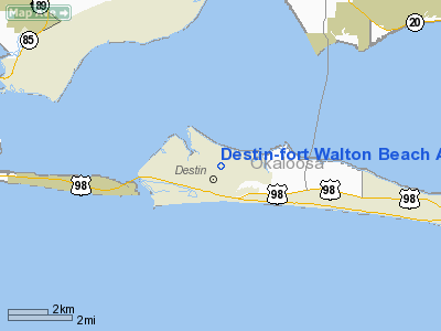
Destin-fort Walton Beach Airport |
| Destin-Fort Walton Beach Airport |
| IATA: DSI – ICAO: KDTS – FAA LID: DTS |
| Summary |
| Airport type |
Public |
| Owner/Operator |
Okaloosa County |
| Location |
Destin, Florida |
| Elevation AMSL |
23 ft / 7 m |
| Coordinates |
30°24′00″N 086°28′17″W / 30.4°N 86.47139°W / 30.4; -86.47139 |
| Runways |
| Direction |
Length |
Surface |
| ft |
m |
| 14/32 |
4,999 |
1,524 |
Asphalt |
| Statistics (1999) |
| Aircraft operations |
63,000 |
| Based aircraft |
75 |
| Source: Federal Aviation Administration |
Destin-Fort Walton Beach Airport (IATA: DSI, ICAO: KDTS, FAA LID: DTS) is a public airport located one mile (2 km) east of the central business district of Destin, a city in Okaloosa County, Florida, United States. This airport is publicly owned by Okaloosa County.
Although most U.S. airports use the same three-letter location identifier for the FAA and IATA, Destin-Fort Walton Beach Airport is assigned DTS by the FAA and DSI by the IATA. The airport's ICAO identifier is KDTS.
Facilities and aircraft
Destin-Fort Walton Beach Airport covers an area of 395 acres (160 ha) which contains one asphalt runway (14/32): 4,999 x 100 ft (1,524 x 30 m).
For 12-month period ending November 19, 1999, the airport had 63,000 aircraft operations, an average of 172 per day: 99% general aviation (62,100), 1% air taxi (600) and <1% military (300). There are 75 aircraft based at this airport: 67% single engine (50), 24% multi engine (18), 7% jet aircraft (5) and 3% helicopters (2).
The above content comes from Wikipedia and is published under free licenses – click here to read more.
Location
& QuickFacts
|
FAA Information Effective: |
2007-01-18 |
|
Airport
Identifier: |
DTS |
|
Airport
Status: |
Operational |
|
Longitude/Latitude: |
086-28-17.3180W/30-24-00.2200N
-86.471477/30.400061 (Estimated) |
|
Elevation: |
23 ft / 7.01 m (Surveyed) |
|
Land: |
395 acres |
|
From
nearest city: |
1 nautical miles E of Destin, FL |
|
Location: |
Okaloosa County, FL |
|
Magnetic Variation: |
01W (2000) |
Owner
& Manager
|
Ownership: |
Publicly owned |
|
Owner: |
Okaloosa Co |
|
Address: |
County Courthouse
Crestview, FL 32536 |
|
Phone
number: |
850-682-2711 |
|
Manager: |
Jerry Sealy |
|
Address: |
1701 State Road 85 N
Eglin Afb, FL 32542 |
|
Phone number: |
850-651-7160
FBO, CINDY HALL 850-837-6135. |
Airport
Operations and Facilities
|
Airport Use: |
Open to public |
|
Wind
indicator: |
Yes |
|
Segmented
Circle: |
Yes |
|
Control
Tower: |
No |
|
Lighting
Schedule: |
DUSK-DAWN |
|
Beacon
Color: |
Clear-Green (lighted land airport) |
|
Landing
fee charge: |
No |
|
Sectional
chart: |
New Orleans |
|
Region: |
ASO - Southern |
|
Boundary
ARTCC: |
ZJX - Jacksonville |
|
Tie-in
FSS: |
GNV - Gainesville |
|
FSS
on Airport: |
No |
|
FSS
Phone: |
850-377-3291 |
|
FSS
Toll Free: |
1-800-WX-BRIEF |
|
NOTAMs
Facility: |
DTS (NOTAM-d service avaliable) |
|
Federal Agreements: |
NGY |
Airport
Communications
|
CTAF: |
123.075 |
|
Unicom: |
123.075 |
Airport
Services
|
Fuel available: |
100LLA |
|
Airframe Repair: |
MAJOR |
|
Power Plant Repair: |
MAJOR |
|
Bottled
Oxygen: |
NONE |
|
Bulk
Oxygen: |
HIGH/LOW |
|
Runway Information
Runway 14/32
|
Dimension: |
4999 x 100 ft / 1523.7 x 30.5 m |
|
Surface: |
ASPH, Good Condition |
|
Weight
Limit: |
Single wheel: 38000 lbs.
Dual wheel: 67000 lbs.
Dual
tandem wheel: 113000 lbs. |
|
Edge
Lights: |
Medium |
|
|
Runway 14 |
Runway 32 |
|
Longitude: |
086-28-34.8300W |
086-27-59.7930W |
|
Latitude: |
30-24-19.7490N |
30-23-40.6820N |
|
Elevation: |
22.00
ft |
21.00
ft |
|
Alignment: |
127 |
127 |
|
Traffic
Pattern: |
Left |
Left |
|
Markings: |
Non-precision instrument, Good Condition |
Non-precision instrument, Good Condition |
|
Crossing
Height: |
41.00 ft |
41.00 ft |
|
VASI: |
4-box on left side |
4-box on left side |
|
Visual
Glide Angle: |
3.00� |
3.00� |
|
Obstruction: |
33 ft trees, 1340.0 ft from runway, 34:1 slope
to clear |
39 ft trees, 1540.0 ft from runway, 34:1 slope
to clear |
|
Radio Navigation
Aids
|
ID |
Type |
Name |
Ch |
Freq |
Var |
Dist |
|
DTS |
NDB |
Destin |
|
254.00 |
01W |
0.3 nm |
|
PKZ |
NDB |
Pickens |
|
326.00 |
01E |
36.7 nm |
|
DWG |
TACAN |
Warrington |
002X |
|
00E |
5.3 nm |
|
HRT |
TACAN |
Hurlburt |
045X |
|
00E |
11.5 nm |
|
NGS |
TACAN |
Santa Rosa |
063X |
|
01E |
27.4 nm |
|
NSE |
TACAN |
Whiting |
070X |
|
01E |
34.3 nm |
|
NPA |
TACAN |
Pensacola |
119X |
|
01E |
43.9 nm |
|
NUN |
VOR |
Saufley |
|
108.80 |
01E |
45.0 nm |
|
CEW |
VORTAC |
Crestview |
106X |
115.90 |
03E |
27.8 nm |
|
PFN |
VORTAC |
Panama City |
090X |
114.30 |
00W |
42.5 nm |
Remarks
- RWY
14/32 HAS A 200' STOPWAY BOTH ENDS.
- EXERCISE
EXTREME VIGILANCE DUE TO CLOSE PROXIMITY TO EGLIN AFB LCTD 6NM NW OF
ARPT.
- ALL
ACFT CTC EGLIN CD ON 121.6 OR 127.7 FOR ATC DEP INSTR PRIOR TO TKOF.
- IFR
ACFT REMAIN ON GROUND - CTC DEP CONTROL FOR CLIMB OUT INSTR AND IFR
RELEASE.
Based Aircraft
|
Aircraft
based on field: |
75 |
|
Single
Engine Airplanes: |
50 |
|
Multi
Engine Airplanes: |
18 |
|
Jet Engine
Airplanes: |
5 |
|
Helicopters: |
2 |
Operational Statistics
Time Period: 1998-11-20
- 1999-11-19
|
Aircraft
Operations: |
173/Day |
|
Air Taxi: |
1.0% |
|
General
Aviation Local: |
24.4% |
|
General
Aviation Itinerant: |
74.1% |
|
Military: |
0.5% |
Destin-fort Walton Beach Airport
Address:
Okaloosa County, FL
Tel:
850-682-2711,
850-651-7160
Images
and information placed above are from
http://www.airport-data.com/airport/DTS/
We
thank them for the data!
| General
Info |
| Country |
United
States |
| State |
FLORIDA
|
| FAA ID |
DTS
|
| Latitude |
30-24-00.220N
|
| Longitude |
086-28-17.318W
|
| Elevation |
23 feet
|
| Near City |
DESTIN
|
We don't guarantee the information is fresh and accurate. The data may
be wrong or outdated.
For more up-to-date information please refer to other sources.
|
|


