 |
|
Coordinates: 30°43′52.0″N 086°09′13.6″W / 30.73111°N 86.153778°W / 30.73111; -86.153778
| DeFuniak Springs Airport |
| IATA: none – ICAO: none – FAA LID: 54J |
| Summary |
| Airport type |
Public use |
| Owner |
City of DeFuniak Springs |
| Operator |
Kim Kirby |
| Serves |
DeFuniak Springs, Florida |
| Location |
Walton County, Florida |
| Elevation AMSL |
289 ft / 88 m |
| Runways |
| Direction |
Length |
Surface |
| ft |
m |
| 09/27 |
4,146 |
1,264 |
Asphalt |
| 18/36 |
2,700 |
823 |
Asphalt |
| Statistics (2000) |
| Aircraft operations |
16,201 |
| Based aircraft |
31 |
| Source: Federal Aviation Administration |
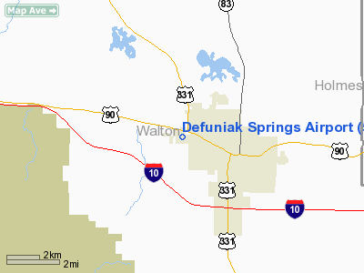
DeFuniak Springs Airport (FAA LID: 54J) is a public-use airport located 2 miles (3.2 km) west of the central business district of the city of DeFuniak Springs in Walton County, Florida, United States. The airport is publicly owned.
The above content comes from Wikipedia and is published under free licenses – click here to read more.
Location
& QuickFacts
|
FAA Information Effective: |
2007-01-18 |
|
Airport
Identifier: |
54J |
|
Airport
Status: |
Operational |
|
Longitude/Latitude: |
086-09-05.7900W/30-43-52.6800N
-86.151608/30.731300 (Estimated) |
|
Elevation: |
289 ft / 88.09 m (Surveyed) |
|
Land: |
159 acres |
|
From
nearest city: |
2 nautical miles W of Defuniak Springs, FL |
|
Location: |
Walton County, FL |
|
Magnetic Variation: |
00E (1985) |
Owner
& Manager
|
Ownership: |
Publicly owned |
|
Owner: |
City Of De Funiak Springs |
|
Address: |
City Hall, Po Box 685
De Funiak Springs, FL 32435 |
|
Phone
number: |
850-892-8500 |
|
Manager: |
Michael G Standley |
|
Address: |
P O Box 685
De Funiak Springs, FL 32435 |
|
Phone number: |
850-892-8500 |
Airport
Operations and Facilities
|
Airport Use: |
Open to public |
|
Wind
indicator: |
Yes |
|
Segmented
Circle: |
No |
|
Control
Tower: |
No |
|
Lighting
Schedule: |
DUSK-DAWN
ACTVT MIRL RY 09/27 - CTAF. |
|
Beacon
Color: |
Clear-Green (lighted land airport) |
|
Landing
fee charge: |
No |
|
Sectional
chart: |
New Orleans |
|
Region: |
ASO - Southern |
|
Boundary
ARTCC: |
ZJX - Jacksonville |
|
Tie-in
FSS: |
GNV - Gainesville |
|
FSS
on Airport: |
No |
|
FSS
Phone: |
850-377-3291 |
|
FSS
Toll Free: |
1-800-WX-BRIEF |
|
NOTAMs
Facility: |
GNV (NOTAM-d service avaliable) |
|
Federal Agreements: |
NGY |
Airport
Communications
|
CTAF: |
122.800 |
|
Unicom: |
122.800 |
Airport
Services
|
Fuel available: |
100LL
SERF-SERVE FUEL AVBL WITH CREDIT CARD. |
|
Airframe Repair: |
MAJOR |
|
Power Plant Repair: |
MAJOR |
|
Bottled
Oxygen: |
NONE |
|
Bulk
Oxygen: |
NONE |
|
Runway Information
Runway 09/27
|
Dimension: |
4100 x 60 ft / 1249.7 x 18.3 m |
|
Surface: |
ASPH, Fair Condition
FIRST 900 FT RY 09 IN GOOD CONDITION, REMAINDER FAIR. |
|
Weight
Limit: |
Single wheel: 20000 lbs. |
|
Edge
Lights: |
Medium |
|
|
Runway 09 |
Runway 27 |
|
Longitude: |
086-09-38.1800W |
086-08-51.3900W |
|
Latitude: |
30-43-57.2000N |
30-43-57.2000N |
|
Elevation: |
286.00 ft |
272.00 ft |
|
Alignment: |
90 |
127 |
|
Traffic
Pattern: |
Left |
Left |
|
Markings: |
Basic, Fair Condition |
Basic, Fair Condition |
|
Obstruction: |
28 ft trees, 1150.0 ft from runway, 33:1 slope
to clear |
30 ft trees, 812.0 ft from runway, 120 ft left
of centerline, 20:1 slope to clear |
|
Runway 18/36
|
Dimension: |
2700 x 50 ft / 823.0 x 15.2 m |
|
Surface: |
DIRT, Fair Condition
FIRST 900 FT RY 09 IN GOOD CONDITION, REMAINDER FAIR. |
|
|
Runway 18 |
Runway 36 |
|
Longitude: |
086-09-11.3900W |
086-09-11.3900W |
|
Latitude: |
30-43-57.1200N |
30-43-30.4000N |
|
Elevation: |
281.00 ft |
271.00 ft |
|
Alignment: |
127 |
127 |
|
Traffic
Pattern: |
Left |
Left |
|
Displaced
threshold: |
165.00 ft
DSPLCD THR MARKED WITH 3 TIRES 5 FT APART PERPENDICULAR TO
DSPLCD THR. |
400.00 ft |
|
Obstruction: |
23 ft rr, 800.0 ft from runway, 34:1 slope
to clear
RY 18 APCH RATIO 41:1 FROM RR TO DSPLCD THLD. |
30 ft trees, 400.0 ft from runway, 13:1 slope
to clear
RY 36 APCH RATIO 26:1 FM TREES TO DSPLCD THLD. |
|
Radio Navigation
Aids
|
ID |
Type |
Name |
Ch |
Freq |
Var |
Dist |
|
DTS |
NDB |
Destin |
|
254.00 |
01W |
25.7 nm |
|
BKK |
NDB |
Tri County |
|
275.00 |
02W |
29.3 nm |
|
OZ |
NDB |
Ruckr |
|
212.00 |
00E |
34.4 nm |
|
JUY |
NDB |
Judd |
|
264.00 |
02W |
36.6 nm |
|
BVG |
NDB |
Boll Weevil |
|
352.00 |
03E |
37.4 nm |
|
LOR |
NDB |
Lowe |
|
269.00 |
03W |
43.3 nm |
|
HYE |
NDB |
Hanchey |
|
221.00 |
00E |
46.1 nm |
|
SMY |
NDB |
Soyya |
|
329.00 |
02W |
48.6 nm |
|
DWG |
TACAN |
Warrington |
002X |
|
00E |
24.4 nm |
|
HRT |
TACAN |
Hurlburt |
045X |
|
00E |
33.3 nm |
|
NGS |
TACAN |
Santa Rosa |
063X |
|
01E |
41.2 nm |
|
NSE |
TACAN |
Whiting |
070X |
|
01E |
44.8 nm |
|
PAM |
TACAN |
Tyndall |
124X |
|
00W |
49.6 nm |
|
FYL |
VOR |
Tri County |
|
108.40 |
08W |
28.8 nm |
|
EDN |
VOR |
Enterprise |
|
116.60 |
03W |
36.3 nm |
|
UIA |
VOR |
Andalusia |
|
110.20 |
00E |
36.9 nm |
|
HEY |
VOR |
Hanchey |
|
110.60 |
02E |
46.4 nm |
|
OZR |
VOR/DME |
Cairns |
049X |
111.20 |
02E |
39.0 nm |
|
CEW |
VORTAC |
Crestview |
106X |
115.90 |
03E |
27.8 nm |
|
PFN |
VORTAC |
Panama City |
090X |
114.30 |
00W |
39.4 nm |
|
RRS |
VORTAC |
Wiregrass |
053X |
111.60 |
02E |
49.8 nm |
Remarks
- ULTRALIGHT
ACTIVITY ON & INVOF ARPT.
- FIRST
900 FT RY 09 SLOPES UPWARD CAUSING LINE OF SIGHT OBSTRUCTION BTN RY
THLDS 09 & 27.
- TREES
OBSTRUCT LINE OF SIGHT BTN THLDS 09 & 36 AND BTN THLDS 27 &
36.
- VFR
ONLY.
Based Aircraft
|
Aircraft
based on field: |
11 |
|
Single
Engine Airplanes: |
9 |
|
Multi
Engine Airplanes: |
1 |
|
Ultralights: |
1 |
Operational Statistics
Time Period: 1999-09-02
- 2000-08-31
|
Aircraft
Operations: |
45/Day |
|
Air Taxi: |
1.2% |
|
General
Aviation Local: |
61.7% |
|
General
Aviation Itinerant: |
30.9% |
|
Military: |
6.2% |
Defuniak Springs Airport
Address:
Walton County, FL
Tel:
850-892-8500
Images
and information placed above are from
http://www.airport-data.com/airport/54J/
We
thank them for the data!
| General
Info |
| Country |
United
States |
| State |
FLORIDA
|
| FAA ID |
54J
|
| Latitude |
30-43-52.680N
|
| Longitude |
086-09-05.790W
|
| Elevation |
289 feet
|
| Near City |
DEFUNIAK
SPRINGS |
We don't guarantee the information is fresh and accurate. The data may
be wrong or outdated.
For more up-to-date information please refer to other sources.
|
|


