|
|
Dade-collier Training And Transition Airport |
Coordinates: 25°51′42″N 080°53′49″W / 25.86167°N 80.89694°W / 25.86167; -80.89694
| Dade-Collier Training and Transition Airport |
| IATA: TNT – ICAO: KTNT – FAA LID: TNT |
| Summary |
| Airport type |
Public |
| Owner |
Miami-Dade County |
| Operator |
Miami-Dade Aviation Department (MDAD) |
| Serves |
Miami, Florida |
| Elevation AMSL |
13 ft / 4 m |
| Runways |
| Direction |
Length |
Surface |
| ft |
m |
| 9/27 |
10,499 |
3,200 |
Asphalt |
| Statistics (2001) |
| Aircraft operations |
14,468 |
| Source: Federal Aviation Administration |
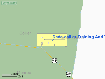
Dade-Collier Training and Transition Airport (IATA: TNT, ICAO: KTNT, FAA LID: TNT) is a public airport located 36 miles (58 km) west of the central business district of Miami, in Collier County, Florida, United States. It is owned by Miami-Dade County and operated by the Miami-Dade Aviation Department. The airport is near the border between Miami-Dade and Collier counties in central South Florida.
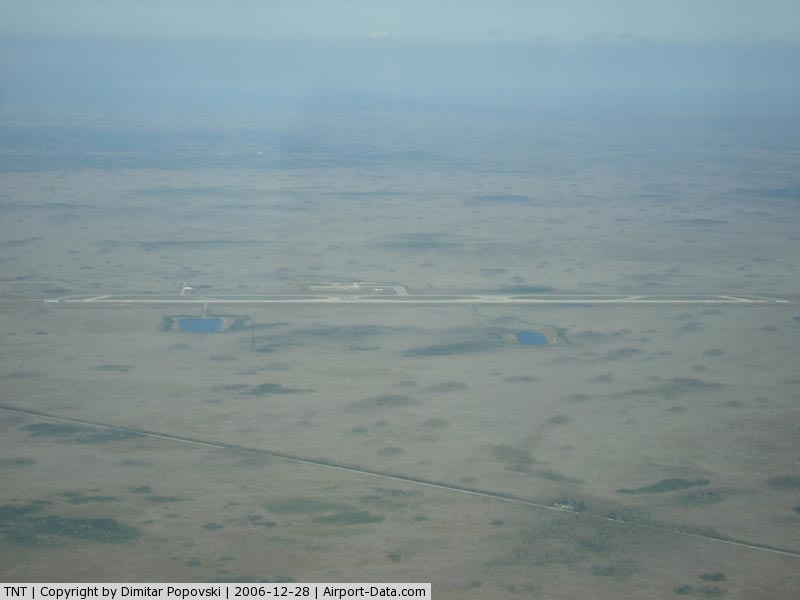
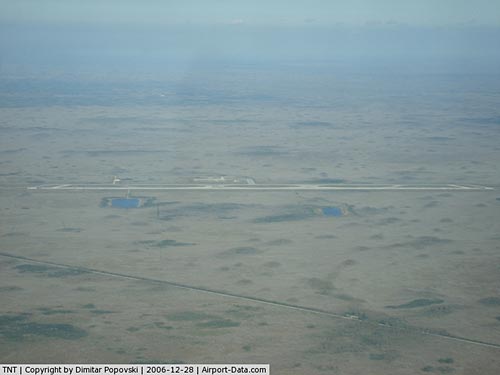
This isolated airport, located within the Florida Everglades, was originally planned to be the largest airport in the world. Begun in 1968, the Everglades Jetport was to be a six runway airport for supersonic aircraft. Because of environmental concerns, construction was halted after the completion of just one runway. The facility remains in use today as an aviation training facility. Facilities and aircraft
Dade-Collier Training and Transition Airport covers an area of 24,960 acres (10,101 ha) which contains one asphalt paved runway (9/27) measuring 10,499 x 150 ft (3,200 x 46 m). For the 12-month period ending December 31, 2001, the airport had 14,468 general aviation aircraft operations, an average of 39 per day.
Accidents
On January 22, 2008, a helicopter practicing maneuvers at the airport crashed, killing both occupants. A preliminary report stated the craft was seen practicing take-offs and landings when it suddenly flipped upside down and crashed, causing the helicopter to explode on impact.
The above content comes from Wikipedia and is published under free licenses – click here to read more.
|
 |
(Click on the photo to enlarge) |
Location
& QuickFacts
|
FAA Information Effective: |
2007-01-18 |
|
Airport
Identifier: |
TNT |
|
Airport
Status: |
Operational |
|
Longitude/Latitude: |
080-53-49.2000W/25-51-42.5000N
-80.897000/25.861806 (Estimated) |
|
Elevation: |
13 ft / 3.96 m (Surveyed) |
|
Land: |
24960 acres |
|
From
nearest city: |
36 nautical miles W of Miami, FL |
|
Location: |
Dade County, FL |
|
Magnetic Variation: |
05W (2000) |
Owner
& Manager
|
Ownership: |
Publicly owned |
|
Owner: |
Miami-dade Avn Dept
GARY DELLAPA; DIRECTOR. |
|
Address: |
Po Box 592075
Miami, FL 33159 |
|
Phone
number: |
305-526-2166 |
|
Manager: |
Mike Handrahan
LCTD AT TAMIAMI APT. |
|
Address: |
12800 Sw 145 Ave
Miami, FL 33186 |
|
Phone number: |
305-869-1700 |
Airport
Operations and Facilities
|
Airport Use: |
Open to public
ARPT CLSD TO PUBLIC EXCP BY ARRANGEMENT WITH DADE COUNTY
AVIATION DEPT MIAMI 305-869-1700. |
|
Wind
indicator: |
Yes |
|
Segmented
Circle: |
Yes |
|
Control
Tower: |
No |
|
Lighting
Schedule: |
DUSK-DAWN
ACTVT HIRL RY 09/27 & SSALS RY 09 - CTAF OR BY CALLING
239-695-3300. |
|
Beacon
Color: |
Clear-Green (lighted land airport) |
|
Landing
fee charge: |
Yes |
|
Sectional
chart: |
Miami |
|
Region: |
ASO - Southern |
|
Boundary
ARTCC: |
ZMA - Miami |
|
Tie-in
FSS: |
MIA - Miami |
|
FSS
on Airport: |
No |
|
FSS
Phone: |
305-233-2600 |
|
FSS
Toll Free: |
1-800-WX-BRIEF |
|
NOTAMs
Facility: |
MIA (NOTAM-d service avaliable) |
|
Federal Agreements: |
NGY |
Airport
Communications
|
CTAF: |
123.000 |
|
Unicom: |
123.000 |
Airport
Services
|
Airframe Repair: |
NONE |
|
Power Plant Repair: |
NONE |
|
Bottled
Oxygen: |
NONE |
|
Bulk
Oxygen: |
NONE |
|
Runway Information
Runway 09/27
|
Dimension: |
10499 x 150 ft / 3200.1 x 45.7 m |
|
Surface: |
ASPH, Good Condition |
|
Surface
Treatment: |
Porous Friction Course |
|
Weight
Limit: |
Single wheel: 130000 lbs.
Dual wheel: 200000 lbs.
Dual tandem wheel: 400000 lbs.
Dual dual tandem wheel: 800000 lbs. |
|
Edge
Lights: |
High |
|
|
Runway 09 |
Runway 27 |
|
Longitude: |
080-54-46.6340W |
080-52-51.7040W |
|
Latitude: |
25-51-42.4920N |
25-51-42.4180N |
|
Elevation: |
13.00
ft |
12.00
ft |
|
Alignment: |
90 |
127 |
|
ILS
Type: |
ILS |
|
|
Traffic
Pattern: |
Left |
Right |
|
Markings: |
Precision instrument, Fair Condition |
Precision instrument, Fair Condition |
|
Crossing
Height: |
0.00
ft |
46.00 ft |
|
VASI: |
|
4-light PAPI on left side |
|
Visual
Glide Angle: |
0.00� |
3.00� |
|
Approach
lights: |
SSALS |
|
|
Radio Navigation
Aids
|
ID |
Type |
Name |
Ch |
Freq |
Var |
Dist |
|
FX |
NDB |
Praiz |
|
221.00 |
02W |
37.7 nm |
|
PJN |
NDB |
Plantation |
|
242.00 |
03W |
40.1 nm |
|
HST |
TACAN |
Homestead |
019X |
|
03W |
35.9 nm |
|
VKZ |
VOR/DME |
Virginia Key |
118X |
117.10 |
04W |
40.7 nm |
|
FLL |
VOR/DME |
Fort Lauderdale |
091X |
114.40 |
00E |
42.2 nm |
|
DHP |
VORTAC |
Dolphin |
086X |
113.90 |
04W |
29.9 nm |
|
MIA |
VOT |
Miami Intl |
|
112.00 |
|
33.7 nm |
Remarks
- THREE
8IN WELLS FLUSH MTD BTN RWY AND TWY.
- FEE
FOR USE FOR ACFT OVER 12500 LBS.
- MAEW
IN BUFFER ISLAND BTN RY 09/27 & TWY.
- WILDLIFE
OCCASIONALLY ON & INVOF ARPT.
- BE
ALERT TO LOW FLYING NATIONAL PARK SVC ACFT ALL QUADRANTS.
Operational Statistics
Time Period: 2001-01-01
- 2001-12-31
|
Aircraft
Operations: |
279/Week |
|
General
Aviation Itinerant: |
100.0% |
Dade-collier Training And Transition Airport
Address:
Dade County, FL
Tel:
305-526-2166,
305-869-1700
Images
and information placed above are from
http://www.airport-data.com/airport/TNT/
We
thank them for the data!
| General
Info |
| Country |
United
States |
| State |
FLORIDA
|
| FAA ID |
TNT
|
| Latitude |
25-51-42.500N
|
| Longitude |
080-53-49.200W
|
| Elevation |
13 feet
|
| Near City |
MIAMI
|
We don't guarantee the information is fresh and accurate. The data may
be wrong or outdated.
For more up-to-date information please refer to other sources.
|
|