 |
|
Coordinates: 28°52′02″N 082°34′17″W / 28.86722°N 82.57139°W / 28.86722; -82.57139
| Crystal River Airport |
| IATA: none – ICAO: KCGC – FAA LID: CGC |
| Summary |
| Airport type |
Public |
| Owner |
Citrus County |
| Serves |
Crystal River, Florida |
| Elevation AMSL |
9 ft / 3 m |
| Runways |
| Direction |
Length |
Surface |
| ft |
m |
| 9/27 |
4,555 |
1,388 |
Asphalt |
| 18/36 |
3,020 |
920 |
Turf |
| Statistics (2002) |
| Aircraft operations |
36,600 |
| Based aircraft |
50 |
| Source: Federal Aviation Administration |
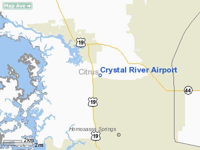
Crystal River Airport (ICAO: KCGC, FAA LID: CGC) is a public airport located three miles (5 km) southeast of the central business district of Crystal River, in Citrus County, Florida, United States. It is owned by Citrus County.
Although most U.S. airports use the same three-letter location identifier for the FAA and IATA, Crystal River Airport is assigned CGC by the FAA but has no designation from the IATA (which assigned CGC to Cape Gloucester, Papua New Guinea).
Facilities and aircraft
Crystal River Airport covers an area of 100 acres (40 ha) which contains two runways: 9/27 with an asphalt surface measuring 4,555 x 75 ft (1,388 x 23 m) and 18/36 with a turf surface measuring 3,020 x 100 ft (920 x 30 m).
For the 12-month period ending May 9, 2002, the airport had 36,600 aircraft operations, an average of 100 per day: 98% general aviation, 1% air taxi and 1% military. There are 50 aircraft based at this airport: 86% single engine, 10% multi-engine, 2% helicopter and 2% glider.
The above content comes from Wikipedia and is published under free licenses – click here to read more.
Location
& QuickFacts
|
FAA Information Effective: |
2007-01-18 |
|
Airport
Identifier: |
CGC |
|
Airport
Status: |
Operational |
|
Longitude/Latitude: |
082-34-16.7000W/28-52-02.2000N
-82.571306/28.867278 (Estimated) |
|
Elevation: |
9 ft / 2.74 m (Surveyed) |
|
Land: |
100 acres |
|
From
nearest city: |
3 nautical miles SE of Crystal River, FL |
|
Location: |
Citrus County, FL |
|
Magnetic Variation: |
02W (1985) |
Owner
& Manager
|
Ownership: |
Publicly owned |
|
Owner: |
County Of Citrus |
|
Address: |
111 West Main St
Inverness, FL 34450 |
|
Phone
number: |
352-637-9400 |
|
Manager: |
Tom Davis |
|
Address: |
Po Box 2050
Crystal River, FL 34423 |
|
Phone number: |
352-795-6868 |
Airport
Operations and Facilities
|
Airport Use: |
Open to public |
|
Wind
indicator: |
Yes |
|
Segmented
Circle: |
Yes |
|
Control
Tower: |
No |
|
Lighting
Schedule: |
DUSK-DAWN
ACTVT MIRL RY 09/27, REIL RY 09, 27 - CTAF. |
|
Beacon
Color: |
Clear-Green (lighted land airport) |
|
Landing
fee charge: |
No |
|
Sectional
chart: |
Jacksonville |
|
Region: |
ASO - Southern |
|
Boundary
ARTCC: |
ZJX - Jacksonville |
|
Responsible
ARTCC: |
ZJX - Jacksonville |
|
Tie-in
FSS: |
PIE - Saint Petersburg |
|
FSS
on Airport: |
No |
|
FSS
Toll Free: |
1-800-WX-BRIEF |
|
NOTAMs
Facility: |
CGC (NOTAM-d service avaliable) |
|
Federal Agreements: |
N |
Airport
Communications
|
CTAF: |
122.725 |
|
Unicom: |
122.725 |
Airport
Services
|
Fuel available: |
100LLA |
|
Airframe Repair: |
MINOR |
|
Power Plant Repair: |
MINOR |
|
Bottled
Oxygen: |
NONE |
|
Bulk
Oxygen: |
NONE |
|
Runway Information
Runway 09/27
|
Dimension: |
4555 x 75 ft / 1388.4 x 22.9 m |
|
Surface: |
ASPH, Good Condition |
|
Edge
Lights: |
Medium |
|
|
Runway 09 |
Runway 27 |
|
Longitude: |
082-34-42.3030W |
082-33-51.0760W |
|
Latitude: |
28-52-02.3650N |
28-52-01.9610N |
|
Elevation: |
7.00
ft |
9.00
ft |
|
Alignment: |
91 |
127 |
|
Traffic
Pattern: |
Left |
Left |
|
Markings: |
Non-precision instrument, Good Condition |
Non-precision instrument, Good Condition |
|
Crossing
Height: |
38.00 ft |
38.00 ft |
|
VASI: |
2-light PAPI on left side |
2-light PAPI on right side |
|
Visual
Glide Angle: |
3.00� |
3.00� |
|
Runway
End Identifier: |
Yes |
Yes |
|
Obstruction: |
15 ft road, 395.0 ft from runway, 13:1 slope
to clear
APCH SLOPE 26:1 TO EOR. |
5 ft road, 350.0 ft from runway, 10:1 slope
to clear
APCH SLOPE 23:1 TO EOR. |
|
Runway 18/36
|
Dimension: |
3020 x 100 ft / 920.5 x 30.5 m |
|
Surface: |
TURF, Fair Condition |
|
|
Runway 18 |
Runway 36 |
|
Longitude: |
082-34-44.3610W |
082-34-44.3610W |
|
Latitude: |
28-52-21.9280N |
28-51-51.9300N |
|
Elevation: |
6.00
ft |
6.00
ft |
|
Traffic
Pattern: |
Left |
Left |
|
Displaced
threshold: |
517.00 ft
/36 DSPLCD THRS MKD WITH GREEN PIPES. BLDGS & FENCE 40
FT FROM CNTRLN BOTH SIDES OF DSPLCD THLD. |
840.00 ft |
|
Obstruction: |
15 ft bldg, 30.0 ft from runway, 20 ft right
of centerline, 2:1 slope to clear
RY 18 APCH RATIO 20:1 TO DSPLCD THLD; +30 FT TREES 600 FT
DSTC 125 FT L. |
56 ft trees, 100.0 ft from runway, 2:1 slope
to clear
RY 36 APCH RATIO 20:1 TO DSPLCD THLD; +56 FT TREES 1120 FT
DSTC 0B. |
|
Radio Navigation
Aids
|
ID |
Type |
Name |
Ch |
Freq |
Var |
Dist |
|
LEE |
NDB |
Leesburg |
|
335.00 |
04W |
40.3 nm |
|
RHZ |
NDB |
Zephyrhills |
|
253.00 |
03W |
44.3 nm |
|
OCF |
VORTAC |
Ocala |
084X |
113.70 |
00E |
26.0 nm |
Remarks
- GLIDER
OPNS WITHIN 25 NM.
- BLDG
30-80' WEST OF RY END.
- AEROBATIC
ACTVT ALONG N SIDE OF RY 09/27 & 4 NM SW OF ARPT. CTC UNICOM FOR
TFC INFO & ST PETERSBURG AFSS FOR SPECIFIC TIMES.
- RY
27 TREES ON BOTH SIDES OF RY IN TRANSITION SFC.
- VFR,
PRIVATE USE ONLY.
Based Aircraft
|
Aircraft
based on field: |
50 |
|
Single
Engine Airplanes: |
43 |
|
Multi
Engine Airplanes: |
5 |
|
Helicopters: |
1 |
|
Gliders: |
1 |
Operational Statistics
Time Period: 2001-05-10
- 2002-05-09
|
Aircraft
Operations: |
101/Day |
|
Air Taxi: |
1.1% |
|
General
Aviation Local: |
49.2% |
|
General
Aviation Itinerant: |
49.2% |
|
Military: |
0.5% |
Crystal River Airport
Address:
Citrus County, FL
Tel:
352-637-9400,
352-795-6868
Images
and information placed above are from
http://www.airport-data.com/airport/CGC/
We
thank them for the data!
| General
Info |
| Country |
United
States |
| State |
FLORIDA
|
| FAA ID |
CGC
|
| Latitude |
28-52-04.067N
|
| Longitude |
082-34-27.744W
|
| Elevation |
9 feet
|
| Near City |
CRYSTAL
RIVER |
We don't guarantee the information is fresh and accurate. The data may
be wrong or outdated.
For more up-to-date information please refer to other sources.
|
|


