|
|
Coordinates: 29°38′07.90″N 083°06′17.10″W / 29.635528°N 83.10475°W / 29.635528; -83.10475
| Cross City Airport |
 |
| 6 February 1999 |
| IATA: CTY – ICAO: KCTY – FAA LID: CTY |
| Summary |
| Airport type |
Public use |
| Owner |
Dixie County Board of Commissioners |
| Operator |
Clint Beauchamp |
| Serves |
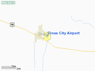
Cross City, Florida |
| Location |
Dixie County, Florida |
| Elevation AMSL |
42 ft / 13 m |
| Runways |
| Direction |
Length |
Surface |
| ft |
m |
| 4/22 |
5,005 |
1,525 |
Asphalt |
| 13/31 |
5,001 |
1,524 |
Asphalt |
| Statistics (2000) |
| Aircraft operations |
18,000 |
| Based aircraft |
11 |
| Source: Federal Aviation Administration |
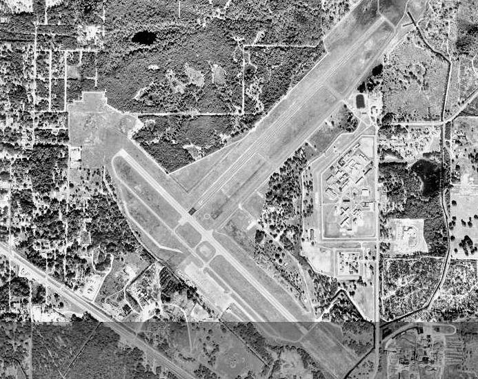
Cross County Army Airfield, 1944 Cross City Airport (IATA: CTY, ICAO: KCTY, FAA LID: CTY) is a public-use airport located 1 mile (1.6 km) west of the central business district of the town of Cross City in Dixie County, Florida, United States. The airport is publicly owned. It was used by the United States Air Force under the name of Cross City Air Force Station
HistoryThe airport was opened as a public airfield in April, 1940. In August 1942, the facility was requisitioned by the United States Army Air Forces as a World War II military airfield, and was named Cross City Army Airfield.The airfield was assigned as a training base to the Army Air Forces School of Applied Tactics (AAFSAT) 50th Fighter Group, headquartered at Orlando Army Air Base.
After the war, the airfield was returned to civil control. However, in the 1950s, the United States Air Force re-established a RADAR facility on the airport under the operational control of the 891st Radar Squadron of the Air Defense Command (ADC). This facility remained at Cross City Air Force Station was part of the ADC's 20th Air Division from 1959 to 1969 when the facility was closed.
The above content comes from Wikipedia and is published under free licenses – click here to read more.
Location
& QuickFacts
|
FAA Information Effective: |
2007-01-18 |
|
Airport
Identifier: |
CTY |
|
Airport
Status: |
Operational |
|
Longitude/Latitude: |
083-06-17.1000W/29-38-07.9000N
-83.104750/29.635528 (Estimated) |
|
Elevation: |
42 ft / 12.80 m (Surveyed) |
|
Land: |
591 acres |
|
From
nearest city: |
1 nautical miles E of Cross City, FL |
|
Location: |
Dixie County, FL |
|
Magnetic Variation: |
02W (1985) |
Owner
& Manager
|
Ownership: |
Publicly owned |
|
Owner: |
Dixie County Board Of Commissioners |
|
Address: |
County Courthouse, Po Box 2426
Cross City, FL 32628 |
|
Phone
number: |
352-498-6656 |
|
Manager: |
Paul Griffin |
|
Address: |
Dixie County Courthouse, Po Box 2426
Cross City, FL 32628 |
|
Phone number: |
352-498-6656 |
Airport
Operations and Facilities
|
Airport Use: |
Open to public |
|
Wind
indicator: |
Yes |
|
Segmented
Circle: |
Yes |
|
Control
Tower: |
No |
|
Lighting
Schedule: |
DUSK-DAWN
ACTVT MIRL RYS 04/22 & 13/31 AND REIL RYS 04, 22, 13
& 31 - CTAF. |
|
Beacon
Color: |
Clear-Green (lighted land airport) |
|
Landing
fee charge: |
No |
|
Sectional
chart: |
Jacksonville |
|
Region: |
ASO - Southern |
|
Boundary
ARTCC: |
ZJX - Jacksonville |
|
Tie-in
FSS: |
GNV - Gainesville |
|
FSS
on Airport: |
No |
|
FSS
Phone: |
850-377-3291 |
|
FSS
Toll Free: |
1-800-WX-BRIEF |
|
NOTAMs
Facility: |
GNV (NOTAM-d service avaliable) |
|
Federal Agreements: |
NP3 |
Airport
Communications
|
CTAF: |
122.800 |
|
Unicom: |
122.800 |
Airport
Services
|
Fuel available: |
100LLA |
|
Airframe Repair: |
NONE |
|
Power Plant Repair: |
NONE |
|
Bottled
Oxygen: |
NONE |
|
Bulk
Oxygen: |
NONE |
|
Runway Information
Runway 04/22
|
Dimension: |
5005 x 75 ft / 1525.5 x 22.9 m |
|
Surface: |
ASPH, Good Condition |
|
Weight
Limit: |
Single wheel: 13000 lbs. |
|
Edge
Lights: |
Medium |
|
|
Runway 04 |
Runway 22 |
|
Longitude: |
083-06-28.4010W |
083-05-49.2690W |
|
Latitude: |
29-38-02.5240N |
29-38-38.3890N |
|
Elevation: |
42.00 ft |
39.00 ft |
|
Alignment: |
44 |
127 |
|
Traffic
Pattern: |
Left |
Left |
|
Markings: |
Basic, Good Condition |
Basic, Good Condition |
|
Crossing
Height: |
38.00 ft |
38.00 ft |
|
VASI: |
2-light PAPI on left side |
2-light PAPI on left side |
|
Visual
Glide Angle: |
3.00� |
3.00� |
|
Runway
End Identifier: |
Yes |
Yes |
|
Obstruction: |
26 ft trees, 1370.0 ft from runway, 45:1 slope
to clear |
, 50:1 slope to clear |
|
Runway 13/31
|
Dimension: |
5001 x 100 ft / 1524.3 x 30.5 m |
|
Surface: |
ASPH, Good Condition |
|
Weight
Limit: |
Single wheel: 13000 lbs. |
|
Edge
Lights: |
Medium |
|
|
Runway 13 |
Runway 31 |
|
Longitude: |
083-06-45.8800W |
083-06-04.8520W |
|
Latitude: |
29-38-12.3390N |
29-37-38.1910N |
|
Elevation: |
41.00 ft |
40.00 ft |
|
Alignment: |
127 |
127 |
|
Traffic
Pattern: |
Left |
Left |
|
Markings: |
Non-precision instrument, Fair Condition |
Non-precision instrument, Fair Condition |
|
Crossing
Height: |
38.00 ft |
38.00 ft |
|
VASI: |
2-light PAPI on left side |
2-light PAPI on left side |
|
Visual
Glide Angle: |
3.00� |
3.00� |
|
Runway
End Identifier: |
Yes |
Yes |
|
Obstruction: |
55 ft trees, 1300.0 ft from runway, 20:1 slope
to clear |
36 ft trees, 1240.0 ft from runway, 40:1 slope
to clear |
|
Radio Navigation
Aids
|
ID |
Type |
Name |
Ch |
Freq |
Var |
Dist |
|
FPY |
NDB |
Foley |
|
254.00 |
03W |
33.2 nm |
|
LCQ |
NDB |
Lake City |
|
204.00 |
03W |
42.9 nm |
|
GN |
NDB |
Wynds |
|
269.00 |
04W |
48.8 nm |
|
CTY |
VORTAC |
Cross City |
057X |
112.00 |
02W |
3.7 nm |
|
GNV |
VORTAC |
Gators |
109X |
116.20 |
04W |
43.6 nm |
Remarks
- RY
04/22 HAS TREES IN TRANSITION SFC NORTHWEST.
Based Aircraft
|
Aircraft
based on field: |
9 |
|
Single
Engine Airplanes: |
7 |
|
Multi
Engine Airplanes: |
1 |
|
Jet Engine
Airplanes: |
1 |
Operational Statistics
Time Period: 1999-07-02
- 2000-06-30
|
Aircraft
Operations: |
50/Day |
|
General
Aviation Local: |
20.0% |
|
General
Aviation Itinerant: |
80.0% |
Cross City Airport
Address:
Dixie County, FL
Tel:
352-498-6656
Images
and information placed above are from
http://www.airport-data.com/airport/CTY/
We
thank them for the data!
| General
Info |
| Country |
United
States |
| State |
FLORIDA
|
| FAA ID |
CTY
|
| Latitude |
29-38-07.900N
|
| Longitude |
083-06-17.100W
|
| Elevation |
42 feet
|
| Near City |
CROSS
CITY |
We don't guarantee the information is fresh and accurate. The data may
be wrong or outdated.
For more up-to-date information please refer to other sources.
|
|