 |
|
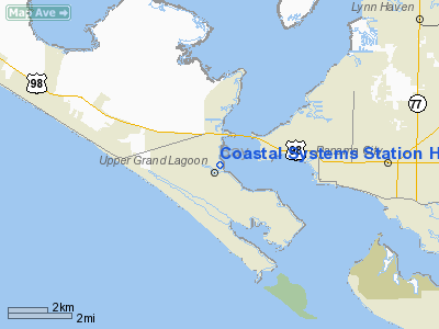
Coastal Systems Station Heliport |
|
|
Location
& QuickFacts
|
FAA
Information Effective: |
2007-01-18 |
|
Airport
Identifier: |
NBV |
|
Airport
Status: |
Operational |
|
Longitude/Latitude: |
085-45-11.7510W/30-10-26.7270N
-85.753264/30.174091 (Estimated) |
|
Elevation: |
10 ft / 3.05 m (Estimated) |
|
Land: |
0 acres |
|
From
nearest city: |
2 nautical miles NW of Panama City, FL |
|
Location: |
Bay County, FL |
|
Magnetic Variation: |
00W (1985) |
Owner
& Manager
|
Ownership: |
Navy owned |
|
Owner: |
U.s. Government (navy) |
|
Address: |
Naval Coastal Systems Center
Panama City, FL 32407 |
|
Manager: |
Commanding Officer |
|
Address: |
Naval Coastal Systems Center
Panama City, FL 32407 |
|
Phone number: |
904-234-4288 |
Airport
Operations and Facilities
|
Airport
Use: |
Private |
|
Wind
indicator: |
Yes |
|
Segmented
Circle: |
No |
|
Control
Tower: |
No |
|
Lighting
Schedule: |
PHONE REQ
FOR LGTS PHONE 904-234-4288. |
|
Landing
fee charge: |
No |
|
Sectional
chart: |
Jacksonville |
|
Region: |
ASO - Southern |
|
Boundary
ARTCC: |
ZJX - Jacksonville |
|
Tie-in
FSS: |
GNV - Gainesville |
|
FSS
on Airport: |
No |
|
FSS
Phone: |
850-377-3291 |
|
FSS
Toll Free: |
1-800-WX-BRIEF |
|
Runway Information
Helipad H1
|
Dimension: |
390 x 296 ft / 118.9 x 90.2 m |
|
Surface: |
CONC, |
|
Edge
Lights: |
Low |
|
|
Runway H1 |
Runway |
|
Traffic
Pattern: |
Left |
Left |
|
Radio Navigation
Aids
|
ID |
Type |
Name |
Ch |
Freq |
Var |
Dist |
|
DTS |
NDB |
Destin |
|
254.00 |
01W |
39.9 nm |
|
BKK |
NDB |
Tri County |
|
275.00 |
02W |
41.5 nm |
|
AAF |
NDB |
Apalachicola |
|
349.00 |
02W |
46.5 nm |
|
PAM |
TACAN |
Tyndall |
124X |
|
00W |
11.2 nm |
|
DWG |
TACAN |
Warrington |
002X |
|
00E |
43.8 nm |
|
FYL |
VOR |
Tri County |
|
108.40 |
08W |
40.8 nm |
|
PFN |
VORTAC |
Panama City |
090X |
114.30 |
00W |
4.5 nm |
|
MAI |
VORTAC |
Marianna |
087X |
114.00 |
00E |
49.1 nm |
Remarks
- PPR
FOR TRANS ACFT. CTC AIR OPS OFFICER DSN 436-5959/4287/4282, C850-235-5959/4287/4282
FOR PPR AND HELIPORT OPR AND CRS RULES PACK.
- NO
TRANSIENT MAINT AVBL; LIMITED PARKING.
- ARR/DEP
ACFT CTC PFN TWR ON 120.5/269.0.
- CTC
HELI CTL ON 135.675/354.6 FOR WINDS, ALTIMETER, GREEN OR RED DECK INFO.
Based Aircraft
|
Aircraft
based on field: |
4 |
|
Helicopters: |
4 |
Coastal Systems Station Heliport
Address:
Bay County, FL
Tel:
904-234-4288
Images
and information placed above are from
http://www.airport-data.com/airport/NBV/
We
thank them for the data!
| General
Info |
| Country |
United
States |
| State |
FLORIDA
|
| FAA ID |
NBV
|
| Latitude |
30-10-26.727N
|
| Longitude |
085-45-11.751W
|
| Elevation |
9 feet
|
| Near City |
PANAMA
CITY |
We don't guarantee the information is fresh and accurate. The data may
be wrong or outdated.
For more up-to-date information please refer to other sources.
|
|


