|
|
Clearwater Air Park Airport |
Coordinates: 27°58′36″N 082°45′31″W / 27.97667°N 82.75861°W / 27.97667; -82.75861
| Clearwater Air Park |
| IATA: CLW – ICAO: KCLW – FAA LID: CLW |
| Summary |
| Airport type |
Public |
| Owner |
City of Clearwater |
| Location |
Clearwater, Florida |
| Elevation AMSL |
71 ft / 22 m |
| Website |
www.ClearwaterAirpark.com |
| Runways |
| Direction |
Length |
Surface |
| ft |
m |
| 16/34 |
3,500 |
1,067 |
Asphalt |
| Statistics (1999) |
| Aircraft operations |
50,590 |
| Based aircraft |
139 |
| Sources: Airport website and FAA |
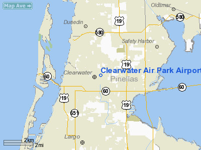
Clearwater Air Park (IATA: CLW, ICAO: KCLW, FAA LID: CLW) is a city-owned public-use airport located three miles (5 km) northeast of the central business district of Clearwater, a city in Pinellas County, Florida, United States.
Facilities and aircraft
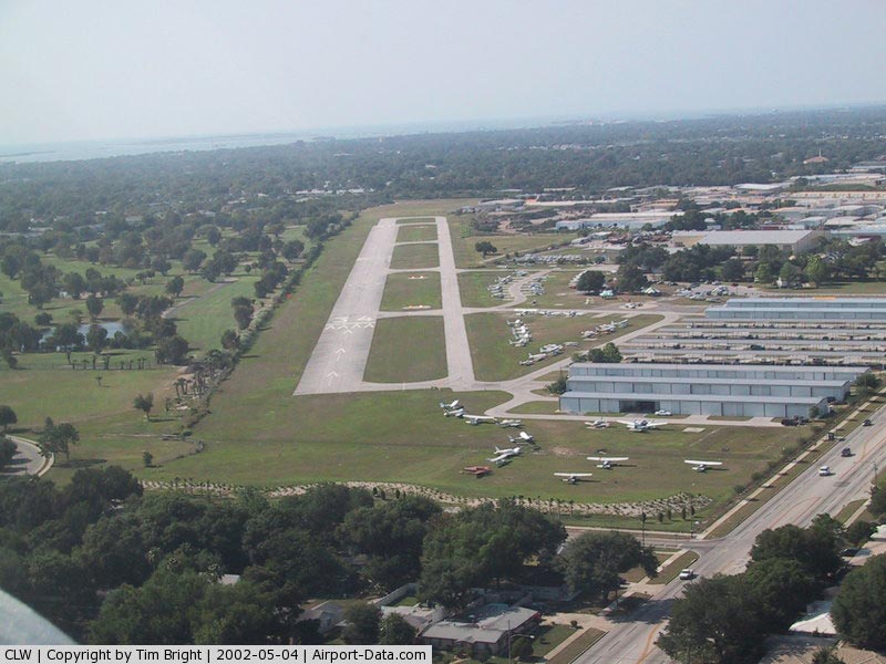
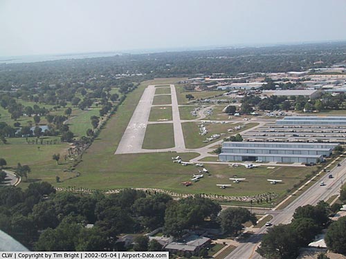
Clearwater Air Park covers an area of 74 acres (30 ha) which contains one asphalt paved runway (16/34) measuring 3,500 x 75 ft (1,067 x 23 m). For the 12-month period ending June 8, 1999, the airport had 50,590 aircraft operations, an average of 138 per day: 99.9% general aviation, <0.1% air taxi and <0.1% military. There are 139 aircraft based at this airport: 87% single-engine, 10% multi-engine and 3% helicopter.
The above content comes from Wikipedia and is published under free licenses – click here to read more.
|
 |
(Click on the photo to enlarge) |
Location
& QuickFacts
|
FAA
Information Effective: |
2007-01-18 |
|
Airport
Identifier: |
CLW |
|
Airport
Status: |
Operational |
|
Longitude/Latitude: |
082-45-31.4650W/27-58-36.0710N
-82.758740/27.976686 (Estimated) |
|
Elevation: |
71 ft / 21.64 m (Surveyed) |
|
Land: |
74 acres |
|
From
nearest city: |
3 nautical miles NE of Clearwater, FL |
|
Location: |
Pinellas County, FL |
|
Magnetic Variation: |
04W (2000) |
Owner
& Manager
|
Ownership: |
Publicly owned |
|
Owner: |
City Of Clearwater |
|
Address: |
Po Box 4748
Clearwater, FL 33758 |
|
Phone
number: |
727-462-6954 |
|
Manager: |
William D Morris
CITY LEASES TO OPNS AMGR RICK EMSHOFF 727-443-3433. |
|
Address: |
25 Causeway Blvd
Clearwater, FL 36767 |
|
Phone number: |
727-462-6954 |
Airport
Operations and Facilities
|
Airport
Use: |
Open to public |
|
Wind
indicator: |
Yes |
|
Segmented
Circle: |
Yes
SEG CIRCLE PAINTED ON RWY. |
|
Control
Tower: |
No |
|
Lighting
Schedule: |
RDO-CTL
ACTVT MIRL RY 16/34 - CTAF. |
|
Landing
fee charge: |
No |
|
Sectional
chart: |
Miami |
|
Region: |
ASO - Southern |
|
Traffic
Pattern Alt: |
1000 ft |
|
Boundary
ARTCC: |
ZJX - Jacksonville |
|
Responsible
ARTCC: |
ZMA - Miami |
|
Tie-in
FSS: |
PIE - Saint Petersburg |
|
FSS
on Airport: |
No |
|
FSS
Toll Free: |
1-800-WX-BRIEF |
|
NOTAMs
Facility: |
PIE (NOTAM-d service avaliable) |
|
Federal Agreements: |
N |
Airport
Communications
|
CTAF: |
123.000 |
|
Unicom: |
123.000 |
Airport
Services
|
Fuel
available: |
100LLA |
|
Airframe
Repair: |
MAJOR |
|
Power
Plant Repair: |
MAJOR |
|
Bottled
Oxygen: |
NONE |
|
Bulk
Oxygen: |
NONE |
|
Runway Information
Runway 16/34
|
Dimension: |
3500 x 75 ft / 1066.8 x 22.9 m |
|
Surface: |
ASPH, Good Condition |
|
Edge
Lights: |
Medium |
|
|
Runway 16 |
Runway 34 |
|
Longitude: |
082-45-39.3600W |
082-45-22.6481W |
|
Latitude: |
27-58-50.8700N |
27-58-19.5542N |
|
Elevation: |
68.00 ft |
70.00 ft |
|
Traffic
Pattern: |
Left |
Right |
|
Markings: |
Basic, Good Condition |
Basic, Good Condition |
|
Crossing
Height: |
26.00 ft |
26.00 ft |
|
Displaced
threshold: |
300.00 ft |
850.00 ft |
|
VASI: |
4-box on left side |
4-box on right side |
|
Visual
Glide Angle: |
3.50� |
3.50� |
|
Obstruction: |
7 ft fence, 200.0 ft from runway, 117 ft right
of centerline
APCH RATIO 34:1 TO DSPLCD THLD.
7 FT FENCE, 125 FT W OF RY CNTRLN. |
7 ft fence, 200.0 ft from runway, 117 ft left
of centerline
APCH RATIO 25:1 TO DSPLCD THLD.
7 FT FENCE, 125 FT W OF RY CNTRLN. |
|
Radio Navigation
Aids
|
ID |
Type |
Name |
Ch |
Freq |
Var |
Dist |
|
AM |
NDB |
Picny |
|
388.00 |
02W |
13.3 nm |
|
TPF |
NDB |
Knight |
|
270.00 |
02W |
16.7 nm |
|
PCM |
NDB |
Plant City |
|
346.00 |
02W |
32.0 nm |
|
RHZ |
NDB |
Zephyrhills |
|
253.00 |
03W |
35.3 nm |
|
MCF |
TACAN |
Macdill |
047X |
|
04W |
14.8 nm |
|
PIE |
VORTAC |
St Petersburg |
111X |
116.40 |
01E |
5.7 nm |
|
SRQ |
VORTAC |
Sarasota |
099X |
115.20 |
02W |
36.5 nm |
|
LAL |
VORTAC |
Lakeland |
107X |
116.00 |
01E |
39.5 nm |
|
TPA |
VOT |
Tampa Intl |
|
111.00 |
|
12.0 nm |
Remarks
- FULL
STOP LNDG ONLY. NO TOUCH & GO.
- RY
16/34 TREES PENETRATE 7:1 TRANS SFC W SIDE.
- NOISE
ABATEMENT PROCEDURES IN EFFECT CTC FBO 727-443-3433.
- VFR
ONLY
Based Aircraft
|
Aircraft
based on field: |
139 |
|
Single
Engine Airplanes: |
121 |
|
Multi
Engine Airplanes: |
14 |
|
Helicopters: |
4 |
Operational Statistics
Time Period: 1998-06-09 - 1999-06-08
|
Aircraft
Operations: |
139/Day |
|
Air Taxi: |
0.1% |
|
General
Aviation Local: |
89.9% |
|
General
Aviation Itinerant: |
10.0% |
|
Military: |
0.0% |
Clearwater Air Park Airport
Address:
Pinellas County, FL
Tel:
727-462-6954
Images
and information placed above are from
http://www.airport-data.com/airport/CLW/
We
thank them for the data!
| General
Info |
| Country |
United
States |
| State |
FLORIDA
|
| FAA ID |
CLW
|
| Latitude |
27-58-36.071N
|
| Longitude |
082-45-31.465W
|
| Elevation |
71 feet
|
| Near City |
CLEARWATER
|
We don't guarantee the information is fresh and accurate. The data may
be wrong or outdated.
For more up-to-date information please refer to other sources.
|
|