 |
|
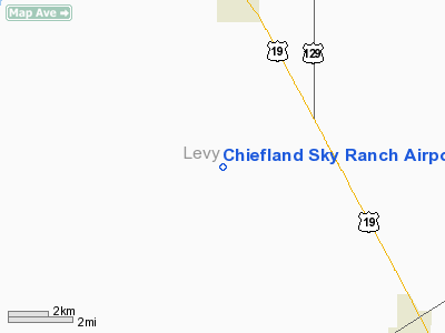
Chiefland Sky Ranch Airport |
Location
& QuickFacts
|
FAA
Information Effective: |
2007-01-18 |
|
Airport
Identifier: |
51FL |
|
Airport
Status: |
Operational |
|
Longitude/Latitude: |
082-52-11.2000W/29-23-41.8000N
-82.869778/29.394944 (Estimated) |
|
Elevation: |
40 ft / 12.19 m (Estimated) |
|
Land: |
0 acres |
|
From
nearest city: |
5 nautical miles S of Chiefland, FL |
|
Location: |
Levy County, FL |
|
Magnetic Variation: |
02W (1985) |
Owner
& Manager
|
Ownership: |
Privately owned |
|
Owner: |
Frank Pitts & Stephen Thompson |
|
Address: |
11230 Nw 129th Place
Chiefland, FL 32626 |
|
Phone
number: |
352-493-2804 |
|
Manager: |
Frank Pitts |
|
Address: |
11230 Nw 129th Place
Chiefland, FL 32626 |
|
Phone number: |
352-493-2804 |
Airport
Operations and Facilities
|
Airport
Use: |
Private |
|
Segmented
Circle: |
No |
|
Control
Tower: |
No |
|
Sectional
chart: |
Jacksonville |
|
Region: |
ASO - Southern |
|
Boundary
ARTCC: |
ZJX - Jacksonville |
|
Tie-in
FSS: |
GNV - Gainesville |
|
FSS
Phone: |
850-377-3291 |
|
FSS
Toll Free: |
1-800-WX-BRIEF |
|
Runway Information
Runway 18/36
|
Dimension: |
2600 x 90 ft / 792.5 x 27.4 m |
|
Surface: |
TURF, |
|
|
Runway 18 |
Runway 36 |
|
Traffic
Pattern: |
Right |
Left |
|
Displaced
threshold: |
910.00 ft |
280.00 ft |
|
Obstruction: |
68 ft trees, 450.0 ft from runway, 6:1 slope
to clear |
15 ft road, 20.0 ft from runway, 1:1 slope
to clear |
|
Radio Navigation
Aids
|
ID |
Type |
Name |
Ch |
Freq |
Var |
Dist |
|
GN |
NDB |
Wynds |
|
269.00 |
04W |
40.1 nm |
|
LCQ |
NDB |
Lake City |
|
204.00 |
03W |
49.9 nm |
|
CTY |
VORTAC |
Cross City |
057X |
112.00 |
02W |
15.4 nm |
|
GNV |
VORTAC |
Gators |
109X |
116.20 |
04W |
36.0 nm |
|
OCF |
VORTAC |
Ocala |
084X |
113.70 |
00E |
36.2 nm |
Remarks
Based Aircraft
|
Aircraft
based on field: |
5 |
|
Single
Engine Airplanes: |
5 |
Operational Statistics
Time Period:
1999-10-02 - 2000-09-30
|
Aircraft
Operations: |
29/Week |
|
General
Aviation Local: |
100.0% |
Chiefland Sky Ranch Airport
Address:
Levy County, FL
Tel:
352-493-2804
Images
and information placed above are from
http://www.airport-data.com/airport/51FL/
We
thank them for the data!
| General
Info |
| Country |
United
States |
| State |
FLORIDA
|
| FAA ID |
51FL
|
| Latitude |
29-23-41.800N
|
| Longitude |
082-52-11.200W
|
| Elevation |
40 feet
|
| Near City |
CHIEFLAND
|
We don't guarantee the information is fresh and accurate. The data may
be wrong or outdated.
For more up-to-date information please refer to other sources.
|
|


