Boca Raton Airport in Florida Florida airports - Boca Raton Airport
Boca Raton Airport in Florida - United States
Florida Airports
USA Airports
World Airports
Airport photos - free!
Aircraft photos - free!
Spacecraft pics - free!
Aviation Articles

Boca Raton Airport


Boca Raton Airport
04 May 2008
IATA: BCT – ICAO: KBCT – FAA LID: BCT
Summary
Airport type Public
Owner State of Florida
Operator Boca Raton Airport Authority
Serves Boca Raton, Florida
Elevation AMSL 13 ft / 4 m
Coordinates 26°22′43″N 080°06′28″W / 26.37861°N 80.10778°W / 26.37861; -80.10778
Runways
Direction Length Surface
ft m
5/23 6,276 1,913 Asphalt
Statistics (2002)
Aircraft operations 91,004
Based aircraft 205
Source: Federal Aviation Administration

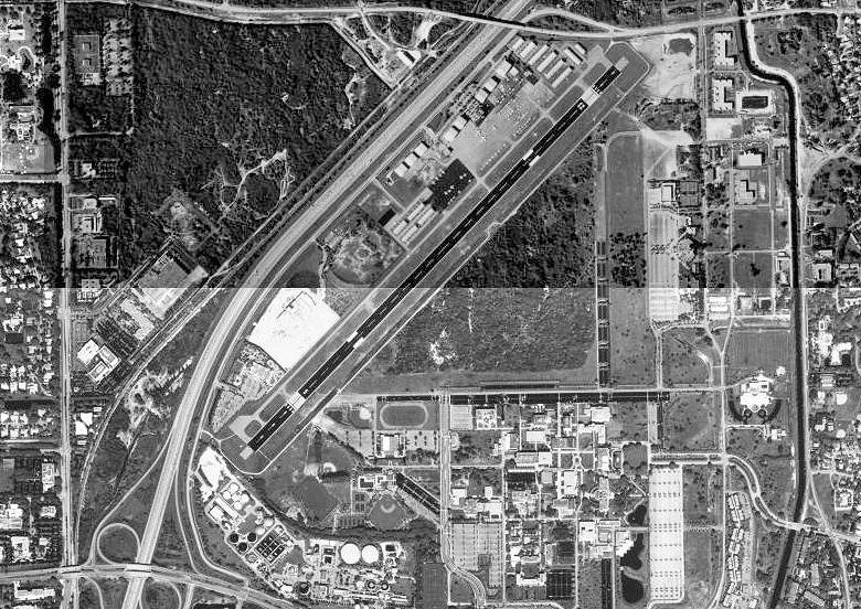
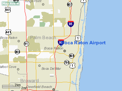
Emblem of the AAFTC Radar school at Boca Raton AAF (1943-1947)

Boca Raton Airport (IATA: BCT, ICAO: KBCT, FAA LID: BCT) is a state-owned public-use airport located two miles (3 km) northwest of the central business district of Boca Raton, a city in Palm Beach County, Florida, United States. The airport is immediately adjacent to Florida Atlantic University and to Interstate 95.

The Boca Raton Airport is publicly owned and is designated as a general aviation transport facility governed by a seven member Authority appointed by the City of Boca Raton and Palm Beach County Commission.

History

Beginnings

The Boca Raton Airport was established in 1936. In 1941, in response to the emerging Axis threat, the United States began to rapidly mobilize and expand its armed forces. In addition to enlarging its Army and Navy, the US also sought to expand its air forces. The service we know today as the U.S. Air Force was known prior to June 1941 as the U.S. Army Air Corps and after June 1941 as the U.S. Army Air Forces, and was a subordinate branch within the U.S. Army. To expand the air corps/air forces, new air bases were established throughout the United States, including bases in southern Florida at Homestead, Morrison Field in West Palm Beach, and at the Boca Raton Airport.

The Boca Raton Airport, also known as Boca Raton Army Airfield, was selected to house a military airfield for a number of geographic and practical reasons. Southern Florida's climate and physical geography are generally considered mild compared to most northern locations. Florida experiences a winter climate characteristic of the subtropics. Lacking snow or low temperatures enabled military operations to continue year round. Florida also has consistently flat terrain, an ideal feature when training new and inexperienced pilots. Its location adjacent to the Atlantic Ocean and the Gulf of Mexico also provided ideal locations for flight training. Boca Raton was also chosen for practical purposes. In the early-1940s, Boca Raton's population numbered only 723. This enabled the United States government to take thousands of acres of land for its use without having to relocate a large number of people. However, this is not to say that the establishment of the military airfield was without controversy. A majority of the land was acquired from Japanese-American farmers from the failing Yamato Colony, the land having been seized through the process of eminent domain, leaving many Japanese-Americans little recourse in the early days of World War II. All of these conditions enabled construction of the military airfield to commence in June 1942.

Recent history

The military inactivated the Boca Raton Army Air Field in 1946 and in the 1950s part of the air base was developed into Florida Atlantic University. Other parts were returned to private ownership and developed, with only 200 acres (0.8 km²) and a single runway of three original runways were retained for airport use. The airport suffered more than $12 million worth of damage to hangars when Hurricane Wilma passed through the area in October 2005.

Facilities and aircraft

Boca Raton Airport covers an area of 212 acres (86 ha) and has one asphalt paved runway designated 5/23 which measures 6,276 x 150 ft (1,913 x 46 m). The airport has a control tower which is manned from 7:00am to 11:00pm. There are two full service fixed base operators, Avitat Boca Raton and Boca Raton Aviation. The Burton D. Morgan School of Aeronautic of Lynn University and a flight training school are located at the airport.

For the 12-month period ending June 20, 2002, the airport had 91,004 aircraft operations, an average of 249 per day: 91% general aviation, 9% air taxi and <1% military. At that time there were 205 aircraft based at this airport: 63% single-engine, 20% multi-engine, 16% jet and 1% helicopter.


The above content comes from Wikipedia and is published under free licenses – click here to read more.

Boca Raton Airport picture

Location & QuickFacts

FAA Information Effective:

2006-09-28

Airport Identifier:

BCT

Longitude/Latitude:

080-06-27.7000W/26-22-42.6000N
-80.107694/26.378500 (Estimated)

Elevation:

13 ft / 3.96 m (Surveyed)

Land:

204 acres

From nearest city:

2 nautical miles NW of Boca Raton, FL

Location:

Palm Beach County, FL

Magnetic Variation:

05W (2000)

Owner & Manager

Ownership:

Publicly owned

Owner:

State Of Florida
ARPT OPERATED BY BOCA RATON AIRPORT AUTHORITY.

Address:

3700 Airport Rd, Suite 304
Boca Raton, FL 33431

Phone number:

561-391-2202

Manager:

Ken A. Day

Address:

3700 Arpt Rd, Suite 304
Boca Raton, FL 33431-6403

Phone number:

561-391-2202

Airport Operations and Facilities

Airport Use:

Open to public

Wind indicator:

Yes

Segmented Circle:

No

Control Tower:

Yes

Attendance Schedule:

ALL/ALL/ALL

Lighting Schedule:

DUSK-DAWN
WHEN ATCT CLSD MIRL RY 05/23 PRESET MED INTENSITY AND REIL RYS 05 & 23 OPER CONTINUOUSLY.

Beacon Color:

Clear-Green (lighted land airport)

Landing fee charge:

No

Sectional chart:

Miami

Region:

ASO - Southern

Traffic Pattern Alt:

1000 ft

Boundary ARTCC:

ZMA - Miami

Tie-in FSS:

MIA - Miami

FSS on Airport:

No

FSS Phone:

305-233-2600

FSS Toll Free:

1-800-WX-BRIEF

NOTAMs Facility:

MIA (NOTAM-d service avaliable)

Federal Agreements:

NGPY

Airport Communications

CTAF:

118.425

Airport Services

Fuel available:

100LLA

Airframe Repair:

MAJOR

Power Plant Repair:

MAJOR

Bottled Oxygen:

NONE

Bulk Oxygen:

HIGH/LOW

Runway Information

Runway 05/23

Dimension:

6276 x 150 ft / 1912.9 x 45.7 m

Surface:

ASPH, Good Condition

Surface Treatment:

Saw-cut or plastic Grooved

Weight Limit:

Single wheel: 40000 lbs.
Dual wheel: 60000 lbs.

Edge Lights:

Medium


Runway 05

Runway 23

Longitude:

080-06-51.8246W

080-06-03.5920W

Latitude:

26-22-20.3215N

26-23-04.7714N

Elevation:

11.00 ft

13.00 ft

Alignment:

44

127

Traffic Pattern:

Left

Right

Markings:

Non-precision instrument, Good Condition

Non-precision instrument, Good Condition

Crossing Height:

40.00 ft

40.00 ft

Displaced threshold:

696.00 ft

378.00 ft

VASI:

4-light PAPI on right side

4-light PAPI on left side

Visual Glide Angle:

3.00°

3.00°

Runway End Identifier:

Yes

Yes

Obstruction:

22 ft trees, 315.0 ft from runway, 5:1 slope to clear
APCH SLOPE 45:1 TO DSPLCD THLD.

6 ft fence, 300.0 ft from runway, 16:1 slope to clear
APCH SLOPE 48:1 TO DSPLCD THLD.

Decleard distances:

Take off run available 6200.00 ft
Take off distance available 6200.00 ft
Actual stop distance available 6200.00 ft
Landing distance available 5550.00 ft

Take off run available 6200.00 ft
Take off distance available 6200.00 ft
Actual stop distance available 6200.00 ft
Landing distance available 5950.00 ft


Radio Navigation Aids

ID

Type

Name

Ch

Freq

Var

Dist

FX

NDB

Praiz


221.00

02W

15.5 nm

PJN

NDB

Plantation


242.00

03W

16.0 nm

PB

NDB

Rubin


356.00

03W

19.4 nm

UTX

NDB

United


405.00

03W

34.1 nm

FLL

VOR/DME

Fort Lauderdale

091X

114.40

00E

18.4 nm

VKZ

VOR/DME

Virginia Key

118X

117.10

04W

37.7 nm

PBI

VORTAC

Palm Beach

104X

115.70

03W

18.2 nm

DHP

VORTAC

Dolphin

086X

113.90

04W

37.1 nm

PHK

VORTAC

Pahokee

101X

115.40

00E

39.7 nm

PBI

VOT

Palm Beach


109.00


18.6 nm

MIA

VOT

Miami Intl


112.00


36.3 nm

Remarks

  • VOLUNTARY NOISE ABATEMENT PROCEDURES IN EFFECT ALL TIMES ALL ACFT. VOLUNTARY CURFEW 2200-0700. USE NBAA STD NOISE ABATEMENT APCH & DEP PRODEDURES.
  • BIRDS ON AND IN VICINITY OF ARPT.
  • ALL ACFT USE RECOMMENDED DEPARTURES: RY 05 L TURN HEADING 360 STAY W OF INTERSTATE TO 1500 FT; RY 23 R TURN HEADING 255 AS SOON AS PRACTICABLE AFT PASSING RY END TO 1500 FT; AVOID RESIDENTIAL AREAS; OVERFLY MALL AREA.
  • TGLS RSTRD TO 0900-1700 MON-FRI; NO STOP & GO LANDINGS OR INTERSECTION DEPS.
  • FOR NOISE ABATEMENT INFO CALL 561-391-2202.
  • VFR OPERNS ONLY.


Based Aircraft

Aircraft based on field:

285

Single Engine Airplanes:

160

Multi Engine Airplanes:

78

Jet Engine Airplanes:

43

Helicopters:

4

Operational Statistics

Aircraft Operations:

362/Day

Air Taxi:

3.4%

General Aviation Local:

37.3%

General Aviation Itinerant:

59.1%

Military:

0.2%


Boca Raton Airport  

Address: Palm Beach County, FL

Tel: 561-391-2202


Images and information placed above are from
http://www.airport-data.com/airport/BCT/

We thank them for the data!


General Info
Country United States
State FLORIDA
FAA ID BCT
Latitude 26-22-42.573N
Longitude 080-06-27.685W
Elevation 13 feet
Near City BOCA RATON


We don't guarantee the information is fresh and accurate. The data may be wrong or outdated.
For more up-to-date information please refer to other sources.


christianity portal
directory of hotels worldwide


Copyright 2004-2024 © by Airports-Worldwide.com, Vyshenskoho st. 36, Lviv 79010, Ukraine
Legal Disclaimer