 |
|
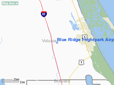
Blue Ridge Flightpark Airport |
|
|
Location
& QuickFacts
|
FAA
Information Effective: |
2006-09-28 |
|
Airport
Identifier: |
34FD |
|
Longitude/Latitude: |
080-54-25.1960W/28-51-25.9620N
-80.906999/28.857212 (Estimated) |
|
Elevation: |
25 ft / 7.62 m (Estimated) |
|
Land: |
7 acres |
|
From
nearest city: |
3 nautical miles W of Oakhill, FL |
|
Location: |
Volusia County, FL |
|
Magnetic Variation: |
04W (1990) |
Owner
& Manager
|
Ownership: |
Privately owned
VAUGHN GRASSO; WARREN BRULL; RON BIRITZ; LYLE GOODIN; C.R.
POWELL; RON JONES; PAUL PUCKETT; JEFF HARTDORN |
|
Owner: |
Ron Biritz/c R Powell |
|
Address: |
P. O. Dr 460
New Smyrna Beach, FL 32170 |
|
Phone
number: |
904-423-1222 |
|
Manager: |
C.r. Powell |
|
Address: |
P. O. Dr 460
New Smyrna Beach, FL 32170 |
|
Phone number: |
904-423-1222 |
Airport
Operations and Facilities
|
Airport Use: |
Private |
|
Wind indicator: |
Yes |
|
Segmented Circle: |
No |
|
Control Tower: |
No |
|
Attendance Schedule: |
UNATNDD |
|
Sectional chart: |
Jacksonville |
|
Region: |
ASO - Southern |
|
Boundary ARTCC: |
ZJX - Jacksonville |
|
Tie-in FSS: |
PIE - Saint Petersburg |
|
FSS Toll Free: |
1-800-WX-BRIEF |
Airport
Communications
|
Runway Information
Runway 17/35
|
Dimension: |
3335 x 100 ft / 1016.5 x 30.5 m |
|
Surface: |
TURF,
SFC TYPE TURF/SANDY. |
|
|
Runway 17 |
Runway 35 |
|
Traffic
Pattern: |
Left |
Left |
|
Radio Navigation
Aids
|
ID |
Type |
Name |
Ch |
Freq |
Var |
Dist |
|
EVB |
NDB |
New Smyrna Beach |
|
417.00 |
04W |
12.0 nm |
|
GGL |
NDB |
Geiger Lake |
|
375.00 |
05W |
16.6 nm |
|
SFB |
NDB |
Sanford |
|
408.00 |
05W |
18.2 nm |
|
DED |
NDB |
Deland/dcmsnd |
|
201.00 |
05W |
23.1 nm |
|
COI |
NDB |
Merritt Island |
|
247.00 |
05W |
33.1 nm |
|
ISM |
NDB |
Kissimmee |
|
329.00 |
05W |
44.0 nm |
|
SQT |
NDB |
Satellite |
|
257.00 |
03W |
46.8 nm |
|
LEE |
NDB |
Leesburg |
|
335.00 |
04W |
47.5 nm |
|
TTS |
TACAN |
Kennedy Space Center |
059Y |
|
00E |
17.8 nm |
|
COF |
TACAN |
Patrick |
097X |
|
04W |
40.4 nm |
|
MLB |
VOR/DME |
Melbourne |
037X |
110.00 |
02W |
47.4 nm |
|
OMN |
VORTAC |
Ormond Beach |
073X |
112.60 |
00E |
28.9 nm |
|
ORL |
VORTAC |
Orlando |
059X |
112.20 |
00E |
29.4 nm |
|
DAB |
VOT |
Daytona Beach |
|
111.00 |
|
21.0 nm |
Remarks
- PRVDD
LNDG FOR PRIVATE USE ONLY.
Based Aircraft
|
Aircraft
based on field: |
20 |
|
Single
Engine Airplanes: |
20 |
Blue Ridge Flightpark Airport
Address:
Volusia County, FL
Tel:
904-423-1222
Images
and information placed above are from
http://www.airport-data.com/airport/34FD/
We
thank them for the data!
| General
Info |
| Country |
United
States |
| State |
FLORIDA
|
| FAA ID |
34FD
|
| Latitude |
28-51-25.962N
|
| Longitude |
080-54-25.196W
|
| Elevation |
25 feet
|
| Near City |
OAKHILL
|
We don't guarantee the information is fresh and accurate. The data may
be wrong or outdated.
For more up-to-date information please refer to other sources.
|
|


