 |
|
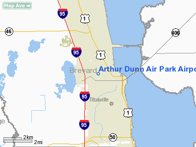
Arthur Dunn Air Park Airport |
Coordinates: 28°37′21.186″N 080°50′07.4749″W / 28.62255167°N 80.835409694°W / 28.62255167; -80.835409694
| Arthur Dunn Airpark |
| IATA: none – ICAO: none – FAA LID: X21 |
| Summary |
| Airport type |
Public use |
| Owner |
Titusville Cocoa Airport Authority |
| Operator |
Michael Powell |
| Serves |
Titusville, Florida |
| Location |
Brevard County, Florida |
| Elevation AMSL |
30 ft / 9 m |
| Website |
http://www.flairport.com/arthurbody.htm |
| Runways |
| Direction |
Length |
Surface |
| ft |
m |
| 04U/22U |
1,805 |
550 |
Turf |
| 15/33 |
2,961 |
903 |
Asphalt |
| Statistics (1999) |
| Aircraft operations |
40,470 |
| Based aircraft |
79 |
| Source: Federal Aviation Administration |
Arthur Dunn Airpark (FAA LID: X21) is a public-use airport located 2 miles (3.2 km) northwest of the central business district of the city of Titusville in Brevard County, Florida, United States. The airport is publicly owned. A skydiving operator is located on the field. History
Brevard County commissioner Arthur Dunn established the Airpark.
The above content comes from Wikipedia and is published under free licenses – click here to read more.
Location
& QuickFacts
|
FAA
Information Effective: |
2006-09-28 |
|
Airport
Identifier: |
X21 |
|
Longitude/Latitude: |
080-50-08.5000W/28-37-20.4400N
-80.835694/28.622344 (Estimated) |
|
Elevation: |
30 ft / 9.14 m (Surveyed) |
|
Land: |
138 acres |
|
From
nearest city: |
2 nautical miles NW of Titusville, FL |
|
Location: |
Brevard County, FL |
|
Magnetic Variation: |
03W (1985) |
Owner
& Manager
|
Ownership: |
Publicly owned |
|
Owner: |
Titusville Cocoa Airport Authority |
|
Address: |
355 Golden Knights Blvd
Titusville, FL 32780 |
|
Phone
number: |
407-267-8780 |
|
Manager: |
Dave Edwards |
|
Address: |
355 Golden Knights Blvd
Titusville, FL 32780 |
|
Phone number: |
407-267-8780 |
Airport
Operations and Facilities
|
Airport
Use: |
Open to public |
|
Wind
indicator: |
Yes |
|
Segmented
Circle: |
Yes |
|
Control
Tower: |
No |
|
Attendance
Schedule: |
ALL/ALL/0800-2000 |
|
Lighting
Schedule: |
DUSK-DAWN
ACTVT MIRL RY 15/33 - CTAF. |
|
Beacon
Color: |
Clear-Green (lighted land airport)
ARPT BCN OTS INDEFLY. |
|
Landing
fee charge: |
No |
|
Sectional
chart: |
Jacksonville |
|
Region: |
ASO - Southern |
|
Traffic
Pattern Alt: |
800 ft |
|
Boundary
ARTCC: |
ZMA - Miami |
|
Responsible
ARTCC: |
ZJX - Jacksonville |
|
Tie-in
FSS: |
PIE - Saint Petersburg |
|
FSS
on Airport: |
No |
|
FSS
Toll Free: |
1-800-WX-BRIEF |
|
NOTAMs
Facility: |
PIE (NOTAM-d service avaliable) |
|
Federal Agreements: |
NGY |
Airport
Communications
|
CTAF: |
123.000 |
|
Unicom: |
123.000 |
Airport
Services
|
Fuel
available: |
100LLA |
|
Airframe
Repair: |
MAJOR |
|
Power
Plant Repair: |
MAJOR |
|
Bottled
Oxygen: |
NONE |
|
Bulk
Oxygen: |
NONE |
|
Runway Information
Runway 04U/22U
|
Dimension: |
1790 x 100 ft / 545.6 x 30.5 m |
|
Surface: |
TURF, Good Condition |
|
|
Runway 04U |
Runway 22U |
|
Longitude: |
080-50-13.5000W |
080-50-01.5000W |
|
Latitude: |
28-37-15.0000N |
28-37-29.2200N |
|
Alignment: |
37 |
127 |
|
Traffic
Pattern: |
Left |
Left |
|
Displaced
threshold: |
100.00 ft |
300.00 ft |
|
Obstruction: |
58 ft trees, 1062.0 ft from runway, 18:1 slope
to clear
APCH RATIO 20:1 TO DSPLCD THLD. |
56 ft trees, 825.0 ft from runway, 14:1 slope
to clear
APCH RATIO 20:1 TO DSPLCD THLD. |
|
Runway 15/33
|
Dimension: |
3000 x 70 ft / 914.4 x 21.3 m |
|
Surface: |
ASPH, Good Condition |
|
Weight
Limit: |
Single wheel: 12000 lbs. |
|
Edge
Lights: |
Medium |
|
|
Runway 15 |
Runway 33 |
|
Longitude: |
080-50-16.0000W |
080-50-02.2000W |
|
Latitude: |
28-37-33.0000N |
28-37-05.9000N |
|
Elevation: |
25.00 ft |
30.00 ft |
|
Alignment: |
127 |
127 |
|
Traffic
Pattern: |
Left |
Left |
|
Markings: |
Basic, Good Condition |
Basic, Good Condition |
|
Crossing
Height: |
53.00 ft |
53.00 ft |
|
Displaced
threshold: |
0.00
ft |
500.00 ft |
|
VASI: |
2-light PAPI on left side |
2-light PAPI on left side |
|
Visual
Glide Angle: |
4.00� |
4.00� |
|
Obstruction: |
20 ft pole, 700.0 ft from runway, 25:1 slope
to clear |
6 ft fence, 200.0 ft from runway, 125 ft right
of centerline
RY 33 APCH RATIO 20:1 TO DSPLCD THLD.
RY
33 6 FT FENCE 55 FT FROM RY END. |
|
Radio Navigation
Aids
|
ID |
Type |
Name |
Ch |
Freq |
Var |
Dist |
|
GGL |
NDB |
Geiger Lake |
|
375.00 |
05W |
2.0 nm |
|
COI |
NDB |
Merritt Island |
|
247.00 |
05W |
18.6 nm |
|
SFB |
NDB |
Sanford |
|
408.00 |
05W |
23.6 nm |
|
EVB |
NDB |
New Smyrna Beach |
|
417.00 |
04W |
26.6 nm |
|
SQT |
NDB |
Satellite |
|
257.00 |
03W |
32.2 nm |
|
DED |
NDB |
Deland/dcmsnd |
|
201.00 |
05W |
35.3 nm |
|
ISM |
NDB |
Kissimmee |
|
329.00 |
05W |
37.4 nm |
|
TTS |
TACAN |
Kennedy Space Center |
059Y |
|
00E |
7.4 nm |
|
COF |
TACAN |
Patrick |
097X |
|
04W |
26.0 nm |
|
MLB |
VOR/DME |
Melbourne |
037X |
110.00 |
02W |
32.8 nm |
|
ORL |
VORTAC |
Orlando |
059X |
112.20 |
00E |
26.8 nm |
|
OMN |
VORTAC |
Ormond Beach |
073X |
112.60 |
00E |
43.4 nm |
|
DAB |
VOT |
Daytona Beach |
|
111.00 |
|
35.5 nm |
Remarks
- EXTENSIVE
ULTRALIGHT ACTIVITY INVOF ARPT.
- SVRL
RADIO TOWERS 1.5 NM SOUTH OF FIELD; THE TALLEST TOWER IS 399 FT AGL.
- FOR
INFO ON RY USE CALL ARPT AUTHORITY 321-267-8780.
- EXISTED
PRIOR TO 1959.
Based Aircraft
|
Aircraft
based on field: |
100 |
|
Single
Engine Airplanes: |
75 |
|
Multi
Engine Airplanes: |
5 |
|
Ultralights: |
20 |
Operational Statistics
|
Aircraft
Operations: |
111/Day |
|
General
Aviation Local: |
74.2% |
|
General
Aviation Itinerant: |
24.7% |
|
Military: |
1.1% |
Arthur Dunn Air Park Airport
Address:
Brevard County, FL
Tel:
407-267-8780
Images
and information placed above are from
http://www.airport-data.com/airport/X21/
We
thank them for the data!
| General
Info |
| Country |
United
States |
| State |
FLORIDA
|
| FAA ID |
X21
|
| Latitude |
28-37-20.444N
|
| Longitude |
080-50-08.502W
|
| Elevation |
30 feet
|
| Near City |
TITUSVILLE
|
We don't guarantee the information is fresh and accurate. The data may
be wrong or outdated.
For more up-to-date information please refer to other sources.
|
|


