 |
|
Location
& QuickFacts
|
FAA
Information Effective: |
2006-09-28 |
|
Airport
Identifier: |
5FD5 |
|
Longitude/Latitude: |
084-58-52.7100W/30-35-43.6990N
-84.981308/30.595472 (Estimated) |
|
Elevation: |
100 ft / 30.48 m (Estimated) |
|
Land: |
7 acres |
|
From
nearest city: |
10 nautical miles E of Blountstown, FL |
|
Location: |
Calhoun County, FL |
|
Magnetic Variation: |
01W (1985) |
Owner
& Manager
|
Ownership: |
Privately owned |
|
Owner: |
Roger J & Brenda Mc Laughlin |
|
Address: |
Rt 2 Box 526
Grand Ridge, FL 32424 |
|
Phone
number: |
850-674-5127 |
|
Manager: |
Roger J & Brenda Mc Laughlin |
|
Address: |
Rt 2 Box 526
Grand Ridge, FL 32424 |
|
Phone number: |
850-674-5127 |
Airport
Operations and Facilities
|
Airport
Use: |
Private |
|
Segmented
Circle: |
No |
|
Control
Tower: |
No |
|
Attendance
Schedule: |
UNATNDD |
|
Sectional
chart: |
New Orleans |
|
Region: |
ASO - Southern |
|
Boundary
ARTCC: |
ZJX - Jacksonville |
|
Tie-in
FSS: |
GNV - Gainesville |
|
FSS
Phone: |
850-377-3291 |
|
FSS
Toll Free: |
1-800-WX-BRIEF |
|
Runway Information
Runway 09/27
|
Dimension: |
2000 x 75 ft / 609.6 x 22.9 m |
|
Surface: |
TURF, |
|
|
Runway 09 |
Runway 27 |
|
Traffic
Pattern: |
Left |
Left |
|
Radio Navigation
Aids
|
ID |
Type |
Name |
Ch |
Freq |
Var |
Dist |
|
SMY |
NDB |
Soyya |
|
329.00 |
02W |
20.8 nm |
|
LYZ |
NDB |
Willis |
|
359.00 |
01W |
32.7 nm |
|
BKK |
NDB |
Tri County |
|
275.00 |
02W |
35.5 nm |
|
TL |
NDB |
Wakul |
|
379.00 |
01W |
36.1 nm |
|
CYR |
NDB |
Caidy |
|
338.00 |
01W |
46.0 nm |
|
PAM |
TACAN |
Tyndall |
124X |
|
00W |
43.9 nm |
|
FYL |
VOR |
Tri County |
|
108.40 |
08W |
35.6 nm |
|
MAI |
VORTAC |
Marianna |
087X |
114.00 |
00E |
13.6 nm |
|
SZW |
VORTAC |
Seminole |
122X |
117.50 |
02E |
31.5 nm |
|
PFN |
VORTAC |
Panama City |
090X |
114.30 |
00W |
42.8 nm |
|
RRS |
VORTAC |
Wiregrass |
053X |
111.60 |
02E |
47.5 nm |
|
TLH |
VOT |
Tallahassee Muni |
|
111.00 |
|
34.5 nm |
Remarks
- PRVDD
VFR/PVT USE; & AS ARPT LCTD WITHIN BOUNDARIES OF SEV LOW LEVEL MILITARY
TRNG RTES; ALL PILOTS SHOULD CONTACT A FSS WITHIN 100 NM OF RTE TO OBTAIN
CURRENT INFO ON RTE USAGE.
Based Aircraft
|
Aircraft
based on field: |
2 |
|
Single
Engine Airplanes: |
2 |
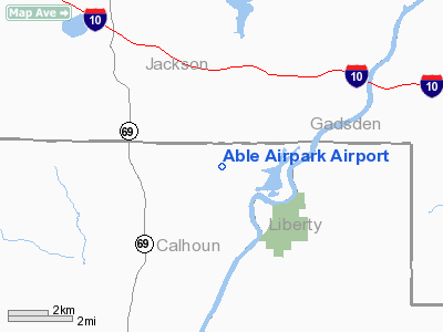
Able Airpark Airport
Address:
Calhoun County, FL
Tel:
850-674-5127
Images
and information placed above are from
http://www.airport-data.com/airport/5FD5/
We
thank them for the data!
| General
Info |
| Country |
United
States |
| State |
FLORIDA
|
| FAA ID |
5FD5
|
| Latitude |
30-35-43.699N
|
| Longitude |
084-58-52.710W
|
| Elevation |
100 feet
|
| Near City |
BLOUNTSTOWN
|
We don't guarantee the information is fresh and accurate. The data may
be wrong or outdated.
For more up-to-date information please refer to other sources.
|
|


