 |
|
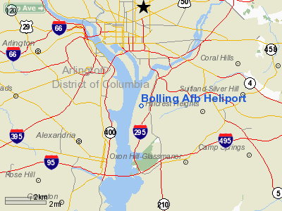
Bolling Air Force Base Heliport |
Location
& QuickFacts
|
FAA
Information Effective: |
2006-09-28 |
|
Airport
Identifier: |
BOF |
|
Longitude/Latitude: |
077-00-57.9140W/38-50-34.4060N
-77.016087/38.842891 (Estimated) |
|
Elevation: |
20 ft / 6.10 m (Estimated) |
|
Land: |
0 acres |
|
From
nearest city: |
4 nautical miles SE of Washington, DC |
|
Location: |
Washington County, DC |
|
Magnetic Variation: |
09W (1985) |
Owner
& Manager
|
Ownership: |
Air Force owned |
|
Owner: |
Usaf |
|
Address: |
Bolling Afb
Washington, DC 20332 |
|
Manager: |
Chief Afld Management |
|
Address: |
Bolling Afb
Washington, DC 20332 |
Airport
Operations and Facilities
|
Airport
Use: |
Private |
|
Segmented
Circle: |
No |
|
Control
Tower: |
No |
|
Attendance
Schedule: |
UNATNDD |
|
Sectional
chart: |
Washington |
|
Region: |
AEA - Eastern |
|
Boundary
ARTCC: |
ZDC - Washington |
|
Tie-in
FSS: |
DCA - Leesburg |
|
FSS
on Airport: |
No |
|
FSS
Phone: |
703-777-2856 |
|
FSS
Toll Free: |
1-800-WX-BRIEF |
|
Runway Information
Helipad H1
|
Dimension: |
100 x 100 ft / 30.5 x 30.5 m |
|
Surface: |
ASPH, |
|
|
Runway H1 |
Runway |
|
Traffic
Pattern: |
Left |
Left |
|
Radio Navigation
Aids
|
ID |
Type |
Name |
Ch |
Freq |
Var |
Dist |
|
DC |
NDB |
Oxonn |
|
332.00 |
11W |
4.6 nm |
|
VKX |
NDB |
Potomac |
|
241.00 |
10W |
6.3 nm |
|
GTN |
NDB |
Georgetown |
|
323.00 |
09W |
7.3 nm |
|
BUH |
NDB |
Anne Arundel |
|
260.00 |
10W |
18.8 nm |
|
GAI |
NDB |
Gaithersburg |
|
385.00 |
09W |
20.9 nm |
|
FND |
NDB |
Ellicott |
|
371.00 |
11W |
29.0 nm |
|
IUB |
NDB |
Institute |
|
404.00 |
08W |
32.3 nm |
|
GDX |
NDB |
Goodwin Lake |
|
227.00 |
08W |
38.7 nm |
|
EZF |
NDB |
Shannon |
|
237.00 |
10W |
40.2 nm |
|
MTN |
NDB |
Martin |
|
342.00 |
11W |
40.4 nm |
|
CJR |
NDB |
Culpeper |
|
252.00 |
09W |
43.7 nm |
|
NHK |
NDB |
Patuxent |
|
400.00 |
10W |
44.2 nm |
|
ESN |
NDB |
Easton |
|
212.00 |
10W |
44.4 nm |
|
APH |
NDB |
A P Hill |
|
396.00 |
10W |
47.7 nm |
|
CGE |
NDB |
Cambridge |
|
355.00 |
10W |
49.7 nm |
|
MTN |
TACAN |
Martin |
068X |
|
11W |
40.7 nm |
|
FDK |
VOR |
Frederick |
|
109.00 |
08W |
38.1 nm |
|
DCA |
VOR/DME |
Washington |
047X |
111.00 |
09W |
1.4 nm |
|
ADW |
VORTAC |
Andrews |
078X |
113.10 |
10W |
7.3 nm |
|
OTT |
VORTAC |
Nottingham |
084X |
113.70 |
10W |
15.1 nm |
|
AML |
VORTAC |
Armel |
082X |
113.50 |
08W |
21.8 nm |
|
BAL |
VORTAC |
Baltimore |
098X |
115.10 |
11W |
25.8 nm |
|
BRV |
VORTAC |
Brooke |
092X |
114.50 |
09W |
34.3 nm |
|
EMI |
VORTAC |
Westminster |
126X |
117.90 |
08W |
39.2 nm |
|
CSN |
VORTAC |
Casanova |
110X |
116.30 |
06W |
41.6 nm |
|
PXT |
VORTAC |
Patuxent |
123X |
117.60 |
10W |
44.2 nm |
|
DCA |
VOT |
Washington National |
|
109.40 |
|
0.8 nm |
|
ADW |
VOT |
Andrews Afb |
|
109.60 |
|
7.2 nm |
Remarks
- (E137-1)
PPR. VFR ONLY. CTC WASHINGTON NATL TWR PRIOR TO ENTERING OR LEAVING
CTLZ ON ESTAB COPTER RTE.
- HELIPAD
IS BLACK ASPHALT WITH PAINTED WHITE MARKINGS ADJ TO ATHLETIC FLD AND
BORDERED BY SMALL TREES AND PAVED ROADS.
- (E137-2)
ALL TFC PAT & GROUND OPN CONDUCTED AT PILOT'S DISCRETION DUE TO
RESTRICTIONS EXISTING AT WASHINGTON TWR.
- (E137-3)
FAC, SVC AND PRK ARE NOT AVBL. AFB IS UNDER PHYSICAL CHG DUE TO MIL
CONST.
- (E137-4)
DO NOT OVERFLY BASE HOUSING AREA.
- (E137-5)
HELIPAD IS UNMRKED.
Bolling Afb Heliport
Address:
Washington County, DC
Tel:
Images
and information placed above are from
http://www.airport-data.com/airport/BOF/
We
thank them for the data!
| General
Info |
| Country |
United
States |
| State |
DIST.
OF COLUMBIA |
| FAA ID |
BOF
|
| Latitude |
38-50-34.406N
|
| Longitude |
077-00-57.914W
|
| Elevation |
20 feet
|
| Near City |
WASHINGTON
|
We don't guarantee the information is fresh and accurate. The data may
be wrong or outdated.
For more up-to-date information please refer to other sources.
|
|


