 |
|
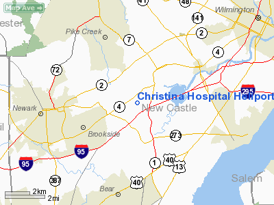
Christina Hospital Heliport |
|
|
Location
& QuickFacts
|
FAA
Information Effective: |
2006-09-28 |
|
Airport
Identifier: |
DE26 |
|
Longitude/Latitude: |
075-40-01.7900W/39-41-15.4000N
-75.667164/39.687611 (Estimated) |
|
Elevation: |
89 ft / 27.13 m (Estimated) |
|
Land: |
0 acres |
|
From
nearest city: |
3 nautical miles W of Newark, DE |
|
Location: |
New Castle County, DE |
|
Magnetic Variation: |
12W (1995) |
Owner
& Manager
|
Ownership: |
Privately owned |
|
Owner: |
Medical Center Of Delaware |
|
Address: |
4755 Ogletown-stanton Road
Newark, DE 19718 |
|
Phone
number: |
302-733-1000 |
|
Manager: |
Robert A. Mulrooney
DIRECTOR OF PLANT ENGINEERING & PUBLIC SAFETY. |
|
Address: |
4755 Ogletown-stanton Road
Newark, DE 19718 |
|
Phone number: |
302-733-3994 |
Airport
Operations and Facilities
|
Airport
Use: |
Private
MEDICAL USE. |
|
Wind
indicator: |
Yes |
|
Segmented
Circle: |
No |
|
Control
Tower: |
No |
|
Attendance
Schedule: |
ALL/ALL/ALL |
|
Lighting
Schedule: |
PHONE REQ
FOR PERIMETER LGTS CALL 302-733-3994. |
|
Sectional
chart: |
Washington |
|
Region: |
AEA - Eastern |
|
Boundary
ARTCC: |
ZDC - Washington |
|
Tie-in
FSS: |
MIV - Millville |
|
FSS
on Airport: |
No |
|
FSS
Phone: |
856-825-8090 |
|
FSS
Toll Free: |
1-800-WX-BRIEF |
|
Runway Information
Helipad H1
|
Dimension: |
120 x 60 ft / 36.6 x 18.3 m |
|
Surface: |
CONC, |
|
|
Runway H1 |
Runway |
|
Traffic
Pattern: |
Left |
Left |
|
Radio Navigation
Aids
|
ID |
Type |
Name |
Ch |
Freq |
Var |
Dist |
|
APG |
NDB |
Aberdeen |
|
349.00 |
11W |
22.3 nm |
|
RNB |
NDB |
Rainbow |
|
363.00 |
11W |
29.5 nm |
|
ING |
NDB |
Ambler |
|
275.00 |
11W |
31.7 nm |
|
NXX |
NDB |
Willow Grove |
|
388.00 |
12W |
38.6 nm |
|
MTN |
NDB |
Martin |
|
342.00 |
11W |
40.5 nm |
|
DYL |
NDB |
Doylestown |
|
237.00 |
10W |
46.3 nm |
|
UKT |
NDB |
Quakertown |
|
208.00 |
12W |
47.5 nm |
|
DOV |
TACAN |
Dover |
037X |
|
09W |
34.6 nm |
|
NXX |
TACAN |
Willow Grove |
061X |
|
10W |
38.8 nm |
|
MTN |
TACAN |
Martin |
068X |
|
11W |
40.6 nm |
|
PNE |
VOR |
North Philadelphia |
|
112.00 |
10W |
38.5 nm |
|
PPM |
VOR/DME |
Phillips |
021X |
108.40 |
09W |
26.9 nm |
|
CKZ |
VOR/DME |
Pennridge |
025Y |
108.85 |
12W |
45.7 nm |
|
ARD |
VOR/DME |
Yardley |
019X |
108.20 |
10W |
48.8 nm |
|
DQO |
VORTAC |
Dupont |
087X |
114.00 |
10W |
2.8 nm |
|
MXE |
VORTAC |
Modena |
079X |
113.20 |
09W |
13.9 nm |
|
OOD |
VORTAC |
Woodstown |
075X |
112.80 |
10W |
17.1 nm |
|
ENO |
VORTAC |
Smyrna |
051X |
111.40 |
09W |
28.3 nm |
|
PTW |
VORTAC |
Pottstown |
112X |
116.50 |
09W |
32.5 nm |
|
VCN |
VORTAC |
Cedar Lake |
099X |
115.20 |
10W |
33.6 nm |
|
LRP |
VORTAC |
Lancaster |
120X |
117.30 |
09W |
38.8 nm |
|
PHL |
VOT |
Philadelphia Intl |
|
109.80 |
|
22.4 nm |
Remarks
- PRVDD
HELICOPTERS OPERATING FM THIS FAC ARE LIMITED TO 12500 LBS MGW; IFR
OPNS ARE NOT CONDUCTED; THERE IS A CLEAR 8:1 INGRESS/EGRESS; IF VASI
IS INSTALLED IN ACCORDANCE WITH AIR CIRCULAR NO FLIGHT CHECK IS NECESSARY.
Christina Hospital Heliport
Address:
New Castle County, DE
Tel:
302-733-1000,
302-733-3994
Images
and information placed above are from
http://www.airport-data.com/airport/DE26/
We
thank them for the data!
| General
Info |
| Country |
United
States |
| State |
DELAWARE
|
| FAA ID |
DE26
|
| Latitude |
39-41-15.400N
|
| Longitude |
075-40-01.790W
|
| Elevation |
89 feet
|
| Near City |
NEWARK
|
We don't guarantee the information is fresh and accurate. The data may
be wrong or outdated.
For more up-to-date information please refer to other sources.
|
|


