 |
|
Chandelle Estates Airport |
| Chandelle Estates Airport |
| IATA: none – ICAO: none – FAA LID: 0N4 |
| Summary |
| Airport type |
Public |
| Owner |
RJR Airdrome, Inc. |
| Serves |
Dover, Delaware |
| Elevation AMSL |
22 ft / 7 m |
| Coordinates |
39°12′08″N 075°29′08″W / 39.20222°N 75.48556°W / 39.20222; -75.48556 |
| Runways |
| Direction |
Length |
Surface |
| ft |
m |
| 4/22 |
2,533 |
772 |
Asphalt |
| Statistics (2007) |
| Aircraft operations |
6,800 |
| Source: Federal Aviation Administration |
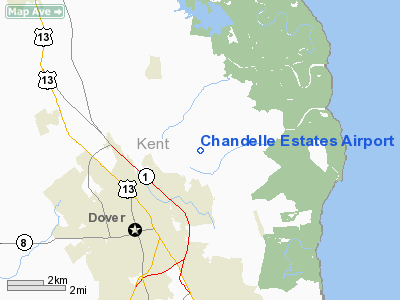
Chandelle Estates Airport (FAA LID: 0N4) is a public use airport located three nautical miles (6 km) northeast of the central business district of Dover, in Kent County, Delaware, United States. It is privately owned by RJR Airdrome, Inc.
Facilities and aircraft
Chandelle Estates Airport covers an area of 27 acres (11 ha) at an elevation of 22 feet (7 m) above mean sea level. It has one asphalt paved runway designated 4/22 which measures 2,533 by 28 feet (772 x 9 m). For the 12-month period ending August 23, 2007, the airport had 6,800 general aviation aircraft operations, an average of 18 per day.
The above content comes from Wikipedia and is published under free licenses – click here to read more.
Location
& QuickFacts
|
FAA
Information Effective: |
2006-09-28 |
|
Airport
Identifier: |
0N4 |
|
Longitude/Latitude: |
075-29-07.7200W/39-12-08.4040N
-75.485478/39.202334 (Estimated) |
|
Elevation: |
22 ft / 6.71 m (Estimated) |
|
Land: |
27 acres |
|
From
nearest city: |
3 nautical miles NE of Dover, DE |
|
Location: |
Kent County, DE |
|
Magnetic Variation: |
11W (1985) |
Owner
& Manager
|
Ownership: |
Privately owned |
|
Owner: |
Rjr Airdrome |
|
Address: |
114 Kruser Blvd
Dover, DE 19901 |
|
Phone number: |
302-736-3447 |
|
Manager: |
Roger Kruser |
|
Address: |
114 Kruser Blvd
Dover, DE 19901 |
|
Phone number: |
302-736-3447 |
Airport
Operations and Facilities
|
Airport
Use: |
Open to public |
|
Wind
indicator: |
Yes |
|
Segmented
Circle: |
Yes |
|
Control
Tower: |
No |
|
Attendance
Schedule: |
ALL/ALL/ALL |
|
Lighting
Schedule: |
RDO-CTL
ACTVT LIRL RY 04/22 & ROTG BCN - 122.7. |
|
Beacon
Color: |
Clear-Green (lighted land airport) |
|
Landing
fee charge: |
No |
|
Sectional
chart: |
Washington |
|
Region: |
AEA - Eastern |
|
Boundary
ARTCC: |
ZDC - Washington |
|
Tie-in
FSS: |
MIV - Millville |
|
FSS
on Airport: |
No |
|
FSS
Phone: |
856-825-8090 |
|
FSS
Toll Free: |
1-800-WX-BRIEF |
|
NOTAMs
Facility: |
MIV (NOTAM-d service avaliable) |
Airport
Communications
|
CTAF: |
122.800 |
|
Unicom: |
122.800 |
Airport
Services
|
Fuel
available: |
100LLMOGAS |
|
Airframe
Repair: |
MAJOR |
|
Power
Plant Repair: |
MAJOR |
|
Bottled
Oxygen: |
NONE |
|
Bulk
Oxygen: |
NONE |
|
Runway Information
Runway 04/22
|
Dimension: |
2533 x 28 ft / 772.1 x 8.5 m |
|
Surface: |
ASPH, Poor Condition
HAS VERTICAL; HORIZONTAL; AND ALLIGATOR CRACKING. |
|
Edge
Lights: |
Low |
|
|
Runway 04 |
Runway 22 |
|
Traffic
Pattern: |
Left |
Left |
|
Markings: |
Nonstandard, Good Condition
& 22 DSPLCD THRS MARKED WITH WHITE LINE; DASHED WHITE
LINES LEADING TO DISPLACEMENT. |
Nonstandard, Good Condition |
|
Displaced
threshold: |
539.00 ft |
538.00 ft |
|
Obstruction: |
35 ft trees, 200.0 ft from runway
APCH SLOPE 21:1 TO DSPLCD THR.
TREES; ROADWAY & POWER LINES ACROSS THE WIDTH OF PRIMARY
SFC. |
40 ft trees, 200.0 ft from runway
RY APCH RATIO 18:1 TO DSPLCD THLD.
TREES & BLDG ACROSS WIDTH OF PRIMARY SFC. |
|
Radio Navigation
Aids
|
ID |
Type |
Name |
Ch |
Freq |
Var |
Dist |
|
RNB |
NDB |
Rainbow |
|
363.00 |
11W |
20.8 nm |
|
APG |
NDB |
Aberdeen |
|
349.00 |
11W |
35.1 nm |
|
ESN |
NDB |
Easton |
|
212.00 |
10W |
36.3 nm |
|
MTN |
NDB |
Martin |
|
342.00 |
11W |
42.1 nm |
|
CGE |
NDB |
Cambridge |
|
355.00 |
10W |
47.4 nm |
|
DOV |
TACAN |
Dover |
037X |
|
09W |
4.3 nm |
|
MTN |
TACAN |
Martin |
068X |
|
11W |
43.8 nm |
|
ATR |
VOR/DME |
Waterloo |
073X |
112.60 |
09W |
26.8 nm |
|
PPM |
VOR/DME |
Phillips |
021X |
108.40 |
09W |
35.6 nm |
|
ENO |
VORTAC |
Smyrna |
051X |
111.40 |
09W |
2.3 nm |
|
OOD |
VORTAC |
Woodstown |
075X |
112.80 |
10W |
27.4 nm |
|
DQO |
VORTAC |
Dupont |
087X |
114.00 |
10W |
29.2 nm |
|
VCN |
VORTAC |
Cedar Lake |
099X |
115.20 |
10W |
31.4 nm |
|
SIE |
VORTAC |
Sea Isle |
095X |
114.80 |
09W |
32.6 nm |
|
MXE |
VORTAC |
Modena |
079X |
113.20 |
09W |
43.9 nm |
|
ACY |
VORTAC |
Atlantic City |
023X |
108.60 |
10W |
44.9 nm |
|
PHL |
VOT |
Philadelphia Intl |
|
109.80 |
|
41.7 nm |
Remarks
- HEAVY
BIRD ACTIVITY ON & INVOF ARPT OCT-FEB.
- VFR
USE ONLY
Based Aircraft
|
Aircraft
based on field: |
202 |
|
Single
Engine Airplanes: |
202 |
Operational Statistics
|
Aircraft
Operations: |
131/Week |
|
General
Aviation Local: |
95.6% |
|
General
Aviation Itinerant: |
4.4% |
Chandelle Estates Airport
Address:
Kent County, DE
Tel:
302-736-3447
Images
and information placed above are from
http://www.airport-data.com/airport/0N4/
We
thank them for the data!
| General
Info |
| Country |
United
States |
| State |
DELAWARE
|
| FAA ID |
0N4
|
| Latitude |
39-12-08.404N
|
| Longitude |
075-29-07.720W
|
| Elevation |
22 feet
|
| Near City |
DOVER
|
We don't guarantee the information is fresh and accurate. The data may
be wrong or outdated.
For more up-to-date information please refer to other sources.
|
|


