 |
|
|
|
|
|
Location
& QuickFacts
|
FAA
Information Effective: |
2006-09-28 |
|
Airport
Identifier: |
N41 |
|
Longitude/Latitude: |
073-02-48.3860W/41-38-00.3490N
-73.046774/41.633430 (Estimated) |
|
Elevation: |
850 ft / 259.08 m (Estimated) |
|
Land: |
62 acres |
|
From
nearest city: |
4 nautical miles N of Waterbury, CT |
|
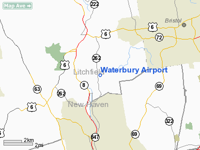
Location: |
Litchfield County, CT |
|
Magnetic Variation: |
14W (1985) |
Owner
& Manager
|
Ownership: |
Privately owned |
|
Owner: |
Killcourse, Shade & Seymour |
|
Address: |
High Ridge Road
Brookfield, CT 06805 |
|
Phone
number: |
203-775-1604 |
|
Manager: |
Steven Shade |
|
Address: |
P.o. Box 272
Plymouth, CT 06782 |
|
Phone number: |
203-283-5819 |
Airport
Operations and Facilities
|
Airport
Use: |
Open to public |
|
Wind
indicator: |
Yes |
|
Segmented
Circle: |
No |
|
Control
Tower: |
No |
|
Attendance
Schedule: |
UNATNDD |
|
Sectional
chart: |
New York |
|
Region: |
ANE - New England |
|
Boundary
ARTCC: |
ZBW - Boston |
|
Tie-in
FSS: |
BDR - Bridgeport |
|
FSS
on Airport: |
No |
|
FSS
Phone: |
866-293-5149 |
|
FSS
Toll Free: |
1-800-WX-BRIEF |
|
NOTAMs
Facility: |
BDR (NOTAM-d service avaliable) |
Airport
Communications
Airport
Services
|
Bottled
Oxygen: |
NONE |
|
Bulk
Oxygen: |
NONE |
|
Runway Information
Runway 02/20
|
Dimension: |
1600 x 250 ft / 487.7 x 76.2 m |
|
Surface: |
TURF, Good Condition
EXTREME CAUTION LNDG/TAXI APCH END RWY 35 WINTER MOS & AFTER
HVY RAIN--POOR DRAINAGE. |
|
|
Runway 02 |
Runway 20 |
|
Traffic
Pattern: |
Left |
Left |
|
Markings: |
None, |
None, |
|
Runway
End Identifier: |
No |
No |
|
Centerline
Lights: |
No |
No |
|
Touchdown
Lights: |
No |
No |
|
Obstruction: |
50 ft trees |
45 ft trees, 0.0 ft from runway |
|
Runway 17/35
|
Dimension: |
2005 x 135 ft / 611.1 x 41.1 m |
|
Surface: |
TURF, Good Condition
EXTREME CAUTION LNDG/TAXI APCH END RWY 35 WINTER MOS & AFTER
HVY RAIN--POOR DRAINAGE. |
|
|
Runway 17 |
Runway 35 |
|
Traffic
Pattern: |
Left |
Left |
|
Markings: |
None, |
None, |
|
Runway
End Identifier: |
No |
No |
|
Centerline
Lights: |
No |
No |
|
Touchdown
Lights: |
No |
No |
|
Obstruction: |
45 ft trees |
15 ft road, 0.0 ft from runway |
|
Radio Navigation
Aids
|
ID |
Type |
Name |
Ch |
Freq |
Var |
Dist |
|
GBR |
FAN MARKER |
Sheffield |
|
|
13W |
32.9 nm |
|
SKU |
FAN MARKER |
Stanwyck |
|
|
12W |
45.3 nm |
|
PSF |
FAN MARKER |
Abyss |
|
|
13W |
50.0 nm |
|
TBY |
NDB |
Waterbury |
|
257.00 |
14W |
7.6 nm |
|
MMK |
NDB |
Meriden |
|
238.00 |
14W |
12.3 nm |
|
HF |
NDB |
Lomis |
|
244.00 |
15W |
18.9 nm |
|
GBR |
NDB |
Great Barrington |
|
395.00 |
14W |
36.7 nm |
|
OP |
NDB |
Old Field Point Light |
|
316.00 |
13W |
39.6 nm |
|
PO |
NDB |
Meier |
|
403.00 |
12W |
41.4 nm |
|
SKU |
NDB |
Stanwyck |
|
261.00 |
12W |
45.3 nm |
|
PFH |
NDB |
Philmont |
|
272.00 |
13W |
48.0 nm |
|
HFD |
VOR/DME |
Hartford |
096X |
114.90 |
13W |
22.4 nm |
|
HVN |
VOR/DME |
New Haven |
035X |
109.80 |
13W |
23.5 nm |
|
MAD |
VOR/DME |
Madison |
041X |
110.40 |
13W |
25.0 nm |
|
PWL |
VOR/DME |
Pawling |
090X |
114.30 |
12W |
26.2 nm |
|
BDR |
VOR/DME |
Bridgeport |
25X |
108.80 |
12W |
28.6 nm |
|
CMK |
VOR/DME |
Carmel |
113X |
116.60 |
12W |
32.1 nm |
|
IGN |
VOR/DME |
Kingston |
123X |
117.60 |
12W |
34.9 nm |
|
CTR |
VOR/DME |
Chester |
098X |
115.10 |
13W |
39.8 nm |
|
CCC |
VOR/DME |
Calverton |
119X |
117.20 |
13W |
43.8 nm |
|
ORW |
VOR/DME |
Norwich |
037X |
110.00 |
14W |
47.3 nm |
|
GON |
VOR/DME |
Groton |
45Y |
110.85 |
14W |
48.4 nm |
|
BDL |
VORTAC |
Bradley |
027X |
109.00 |
14W |
24.5 nm |
|
BAF |
VORTAC |
Barnes |
077X |
113.00 |
14W |
35.0 nm |
|
CEF |
VORTAC |
Westover |
87X |
114.00 |
14W |
41.1 nm |
|
HFD |
VOT |
Hartford |
|
108.20 |
|
18.8 nm |
|
BDL |
VOT |
Bradley Intl |
|
111.40 |
|
24.5 nm |
|
BDR |
VOT |
Bridgeport |
|
109.25 |
|
28.6 nm |
|
GON |
VOT |
Groton |
|
110.25 |
|
48.5 nm |
Remarks
- TURF
RWYS ARE SOFT DURING WET PERIODS.
- EXISTED
PRIOR TO 1959.
Based Aircraft
|
Aircraft
based on field: |
25 |
|
Single
Engine Airplanes: |
10 |
|
Gliders: |
12 |
|
Ultralights: |
3 |
Operational Statistics
|
Aircraft
Operations: |
44/Day |
|
General
Aviation Local: |
99.2% |
|
General
Aviation Itinerant: |
0.7% |
|
Military: |
0.1% |
Waterbury Airport
Address:
Litchfield County, CT
Tel:
203-775-1604,
203-283-5819
Images
and information placed above are from
http://www.airport-data.com/airport/N41/
We
thank them for the data!
| General
Info |
| Country |
United
States |
| State |
CONNECTICUT
|
| FAA ID |
N41
|
| Latitude |
41-38-00.349N
|
| Longitude |
073-02-48.386W
|
| Elevation |
850 feet
|
| Near City |
WATERBURY
|
We don't guarantee the information is fresh and accurate. The data may
be wrong or outdated.
For more up-to-date information please refer to other sources.
|
|


