 |
|
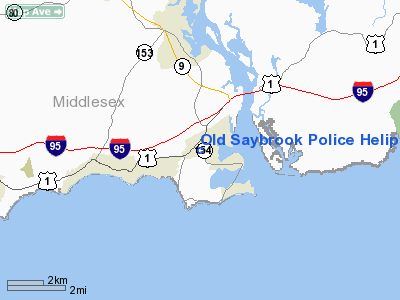
Old Saybrook Police Heliport |
|
|
Location
& QuickFacts
|
FAA
Information Effective: |
2006-09-28 |
|
Airport
Identifier: |
CT99 |
|
Longitude/Latitude: |
072-22-44.3040W/41-17-26.3540N
-72.378973/41.290654 (Estimated) |
|
Elevation: |
16 ft / 4.88 m (Estimated) |
|
Land: |
0 acres |
|
From
nearest city: |
0 nautical miles N of Old Saybrook, CT |
|
Location: |
Middlesex County, CT |
|
Magnetic Variation: |
14W (1985) |
Owner
& Manager
|
Ownership: |
Publicly owned |
|
Owner: |
Town Of Old Saybrook |
|
Address: |
Police Dept, 225 Main Street
Old Saybrook, CT 06475 |
|
Phone
number: |
203-388-3508 |
|
Manager: |
Sgt. Richard Nigosanti |
|
Address: |
Police Dept, 225 Main Street
Old Saybrook, CT 06475 |
|
Phone number: |
203-388-3508 |
Airport
Operations and Facilities
|
Airport
Use: |
Private |
|
Wind
indicator: |
Yes |
|
Segmented
Circle: |
No |
|
Control
Tower: |
No |
|
Attendance
Schedule: |
ALL/ALL/ALL |
|
Lighting
Schedule: |
PHONE REQ
FOR PERIMETER LGTS CALL 203-388-3508. |
|
Beacon
Color: |
Clear-Green-Yellow (heliport) |
|
Landing
fee charge: |
No |
|
Sectional
chart: |
New York |
|
Region: |
ANE - New England |
|
Boundary
ARTCC: |
ZBW - Boston |
|
Tie-in
FSS: |
BDR - Bridgeport |
|
FSS
on Airport: |
No |
|
FSS
Phone: |
866-293-5149 |
|
FSS
Toll Free: |
1-800-WX-BRIEF |
|
Runway Information
Helipad H1
|
Dimension: |
60 x 60 ft / 18.3 x 18.3 m |
|
Surface: |
ASPH, |
|
|
Runway H1 |
Runway |
|
Traffic
Pattern: |
Left |
Left |
|
Radio Navigation
Aids
|
ID |
Type |
Name |
Ch |
Freq |
Var |
Dist |
|
HF |
NDB |
Lomis |
|
244.00 |
15W |
23.5 nm |
|
MMK |
NDB |
Meriden |
|
238.00 |
14W |
24.2 nm |
|
TBY |
NDB |
Waterbury |
|
257.00 |
14W |
37.3 nm |
|
OP |
NDB |
Old Field Point Light |
|
316.00 |
13W |
38.4 nm |
|
FOK |
TACAN |
Suffolk Co |
047X |
|
13W |
29.5 nm |
|
MAD |
VOR/DME |
Madison |
041X |
110.40 |
13W |
14.2 nm |
|
GON |
VOR/DME |
Groton |
45Y |
110.85 |
14W |
15.0 nm |
|
HFD |
VOR/DME |
Hartford |
096X |
114.90 |
13W |
22.4 nm |
|
HVN |
VOR/DME |
New Haven |
035X |
109.80 |
13W |
22.9 nm |
|
ORW |
VOR/DME |
Norwich |
037X |
110.00 |
14W |
23.4 nm |
|
CCC |
VOR/DME |
Calverton |
119X |
117.20 |
13W |
28.9 nm |
|
BDR |
VOR/DME |
Bridgeport |
25X |
108.80 |
12W |
34.6 nm |
|
SEY |
VOR/DME |
Sandy Point |
125X |
117.80 |
15W |
37.0 nm |
|
PUT |
VOR/DME |
Putnam |
121X |
117.40 |
14W |
46.6 nm |
|
HTO |
VORTAC |
Hampton |
083X |
113.60 |
13W |
22.5 nm |
|
BDL |
VORTAC |
Bradley |
027X |
109.00 |
14W |
41.5 nm |
|
GON |
VOT |
Groton |
|
110.25 |
|
15.0 nm |
|
HFD |
VOT |
Hartford |
|
108.20 |
|
29.4 nm |
|
BDR |
VOT |
Bridgeport |
|
109.25 |
|
34.6 nm |
|
BDL |
VOT |
Bradley Intl |
|
111.40 |
|
41.3 nm |
|
ISP |
VOT |
Long Island Mac Arthur |
|
109.40 |
|
44.3 nm |
Remarks
- VFR,
POLICE/MEDICAL USE ONLY; INGRESS/EGRESS LIMITED TO 80 DEG TO 260 DEG;
TOWERS EAST & WINDSOCK ARE OBSTRUCTION LIGHTED.
Based Aircraft
|
Aircraft
based on field: |
1 |
|
Helicopters: |
1 |
Old Saybrook Police Heliport
Address:
Middlesex County, CT
Tel:
203-388-3508
Images
and information placed above are from
http://www.airport-data.com/airport/CT99/
We
thank them for the data!
| General
Info |
| Country |
United
States |
| State |
CONNECTICUT
|
| FAA ID |
CT99
|
| Latitude |
41-17-26.354N
|
| Longitude |
072-22-44.304W
|
| Elevation |
16 feet
|
| Near City |
OLD SAYBROOK
|
We don't guarantee the information is fresh and accurate. The data may
be wrong or outdated.
For more up-to-date information please refer to other sources.
|
|


