|
|
Igor I Sikorsky Memorial Airport |
| Igor I. Sikorsky Memorial Airport |
 |
| Photo as of 17 April 1991 |
 |
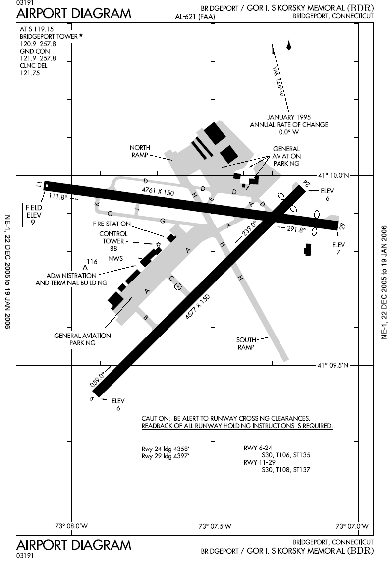
| FAA airport diagram |
| IATA: BDR – ICAO: KBDR – FAA LID: BDR |
| Summary |
| Airport type |
Public |
| Owner |
City of Bridgeport |
| Serves |
Bridgeport, Connecticut |
| Location |
Stratford, Connecticut |
| Elevation AMSL |
9 ft / 3 m |
| Coordinates |
41°09′51″N 073°07′32″W / 41.16417°N 73.12556°W / 41.16417; -73.12556 |
| Runways |
| Direction |
Length |
Surface |
| ft |
m |
| 6/24 |
4,677 |
1,426 |
Asphalt |
| 11/29 |
4,761 |
1,451 |
Asphalt |
| Helipads |
| Number |
Length |
Surface |
| ft |
m |
| H1 |
40 |
12 |
Asphalt |
| Statistics (2007) |
| Aircraft operations |
77,617 |
| Based aircraft |
241 |
| Source: Federal Aviation Administration |
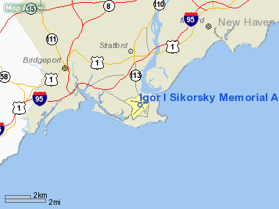
Igor I. Sikorsky Memorial Airport (IATA: BDR, ICAO: KBDR, FAA LID: BDR), formerly known as Bridgeport Municipal Airport, is a public airport located in Stratford, three miles (5 km) southeast of the central business district of Bridgeport, in Fairfield County, Connecticut, United States. In the past, the airport was usually referred to on destination maps and flight status displays as "Bridgeport", the largest city in Connecticut.
The airport has a passenger terminal, general aviation terminal, and several private hangars. The passenger terminal contains airline check-in counters and offices, three arrival/departure gates, rental car desks, and a restaurant. The last commercial service at the airport was provided by US Helicopter, which offered scheduled service to New York's Downtown Manhattan Heliport, and continuing service to John F. Kennedy International Airport. On 25 September 2009, US Helicopter suddenly shut down, ending their service. Facilities and aircraft
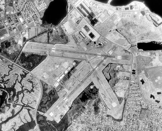
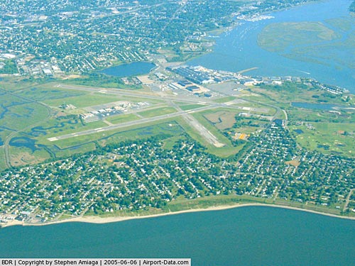
Igor I. Sikorsky Memorial Airport covers an area of 800 acres (324 ha) at an elevation of 9 feet (3 m) above mean sea level. It has two asphalt paved runways: 6/24 measuring 4,677 by 150 feet (1,426 x 46 m) and 11/29 measuring 4,761 by 150 feet (1,451 x 46 m). It also has one helipad measuring 40 by 40 feet (12 x 12 m).
For the 12-month period ending February 28, 2007, the airport had 77,617 aircraft operations, an average of 212 per day: 96% general aviation, 3% air taxi and 1% military. There are 241 aircraft based at this airport: 72% single engine, 11% multi-engine, 15% jet aircraft, 2% helicopters and <1% ultralight.
History
The airport was originally Avon Field, a racetrack where aircraft landed on the grass infield. It was the site of the country's first air show held in 1911, on the grounds of what is currently St. Michaels Cemetery. It became known as Mollison Field after Captain Jim Mollison's crash landing there in 1933 during an attempt to fly across the Atlantic. The City of Bridgeport purchased the airport in 1937, after which it became Bridgeport Municipal Airport. In 1972, it was rededicated as the Igor I. Sikorsky Memorial Airport, honoring the airport's most famous tenant, Igor Sikorsky, who selected Stratford as the site for his Sikorsky Aviation Corporation in 1929.
Controversy
At one time in the 1980s, the airport was simultaneously serviced by three carriers, US Airways Express, Delta Connection, and Continental Connection, however service to the airport declined rapidly in the 1990s. Airlines complained that the short length of the runway was preventing them from flying larger planes into the airport, and reducing profit. Continental Connection discontinued service to the airport in 1994, followed soon after by Delta Connection, which ended service in 1997. Finally, in November 1999, US Airways Express ended service to the airport, leaving Bridgeport with no commercial service.
The airport has been the subject of heated debate in the municipalities of Stratford and Bridgeport. While the City of Bridgeport owns the airport, the entirety of the property is located in the Town of Stratford. Before the end of World War II there was little more than salt marshes surrounding the airport, but in the 1950s and 1960s Stratford permitted extensive residential development in the Lordship area adjacent to the airfield. Bridgeport has pushed for runway and terminal expansion, hoping to attract new service to the airport, arguing that service to the airport is necessary for the growth of Bridgeport's economy. Stratford has opposed terminal expansion and any runway lengthening that would interfere with existing local roads. Even when the airport was served by major carriers, Stratford advocated for strict limits on flights in and out the airport because of noise impinging upon the Lordship and South End neighborhoods. In 2003, the Federal Aviation Administration mandated the lengthening of the two runways to accommodate unpaved safety overruns at each end. Stratford and Connecticut officials have vigorously resisted the FAA effort to install the overruns, but the FAA has notified Stratford, Bridgeport and state officials that it may obtain a federal court order to use eminent domain to complete necessary work to add the overruns.
In June 2006, US Helicopter began scheduled service to New York's Downtown Manhattan Heliport, with continuing service to John F. Kennedy International Airport. This marked the first time since 1999 that the airport welcomed regularly scheduled commercial airline flights. On 25 September 2009, US Helicopter suddenly shut down, ending their service.
In February 2007, state legislators from Bridgeport, in an effort to force expansion, introduced legislation allowing the State of Connecticut to take over the airport. Officials from Stratford would prefer the town take ownership of the airport and oppose the proposed state takeover.
Cargo
- FedEx Express
- FedEx Feeder operated by Wiggins Airways (Hartford)
The above content comes from Wikipedia and is published under free licenses – click here to read more.
|
 |
(Click on the photo to enlarge) |
Location
& QuickFacts
|
FAA
Information Effective: |
2006-09-28 |
|
Airport
Identifier: |
BDR |
|
Longitude/Latitude: |
073-07-34.2000W/41-09-48.5000N
-73.126167/41.163472 (Estimated) |
|
Elevation: |
9 ft / 2.74 m (Surveyed) |
|
Land: |
800 acres |
|
From
nearest city: |
3 nautical miles SE of Bridgeport, CT |
|
Location: |
Fairfield County, CT |
|
Magnetic Variation: |
14W (1985) |
Owner
& Manager
|
Ownership: |
Publicly owned |
|
Owner: |
City Of Bridgeport |
|
Address: |
45 Lyon Terrace
Bridgeport, CT 06604 |
|
Phone
number: |
203-576-7201 |
|
Manager: |
John Ricci |
|
Address: |
1000 Great Meadow Rd
Stratford, CT 06497 |
|
Phone number: |
203-576-8163 |
Airport
Operations and Facilities
|
Airport
Use: |
Open to public |
|
Wind
indicator: |
Yes |
|
Segmented
Circle: |
Yes |
|
Control
Tower: |
Yes |
|
Attendance
Schedule: |
ALL/ALL/0630-2200 |
|
Lighting
Schedule: |
DUSK-DAWN
ACTVT HIRL RYS 11/29 & 06/24; REIL RYS 06 24 11 &
29 - CTAF. |
|
Beacon
Color: |
Clear-Green (lighted land airport) |
|
Landing
fee charge: |
Yes
PARKING FEE ALL ACFT AFTER 2 HRS. LANDING FEE ALL ACFT EXCEPT
SOLO STUDENTS. |
|
Sectional
chart: |
New York |
|
Region: |
ANE - New England |
|
Boundary
ARTCC: |
ZBW - Boston |
|
Responsible
ARTCC: |
ZNY - New York |
|
Tie-in
FSS: |
BDR - Bridgeport |
|
FSS
on Airport: |
Yes |
|
FSS
Phone: |
866-293-5149 |
|
FSS
Toll Free: |
1-800-WX-BRIEF |
|
NOTAMs
Facility: |
BDR (NOTAM-d service avaliable) |
|
Certification type/date: |
I AS 5/1973 |
|
Federal Agreements: |
NGSPY3 |
Airport
Communications
|
CTAF: |
120.900 |
|
Unicom: |
123.000 |
Airport
Services
|
Fuel
available: |
100LLA |
|
Airframe
Repair: |
MAJOR |
|
Power
Plant Repair: |
MAJOR |
|
Bottled
Oxygen: |
HIGH/LOW |
|
Runway Information
Runway 06/24
|
Dimension: |
4677 x 150 ft / 1425.5 x 45.7 m |
|
Surface: |
ASPH,
RWY HAS EXTENSIVE CRACKING, SPALLING, RAVELLING |
|
Weight
Limit: |
Single wheel: 30000 lbs.
Dual wheel: 106000 lbs. |
|
Edge
Lights: |
High |
|
|
Runway 06 |
Runway 24 |
|
Longitude: |
073-07-55.0421W |
073-07-11.7989W |
|
Latitude: |
41-09-25.3598N |
41-09-58.0324N |
|
Elevation: |
6.00 ft |
6.00 ft |
|
Alignment: |
45 |
127 |
|
ILS
Type: |
ILS/DME |
|
|
Traffic
Pattern: |
Left |
Left |
|
Markings: |
Precision instrument, Good Condition |
Non-precision instrument, Good Condition |
|
Crossing
Height: |
53.00 ft |
52.00 ft |
|
Displaced
threshold: |
0.00 ft |
319.00 ft |
|
VASI: |
4-light PAPI on right side |
4-box on left side |
|
Visual
Glide Angle: |
3.00� |
3.00� |
|
Runway
End Identifier: |
Yes |
Yes |
|
Obstruction: |
19 ft road, 480.0 ft from runway, 525 ft left
of centerline, 14:1 slope to clear |
19 ft road, 200.0 ft from runway, 150 ft left
of centerline, 1:1 slope to clear
APCH RATIO 34:1 TO DSPLCD THLD.
+16' POLE-L 0' FM EOR 350' R OF CNTRLN; +4' BERM 0' FM EOR;
+12' FENCE 20' FM EOR. |
|
Runway 11/29
|
Dimension: |
4761 x 150 ft / 1451.2 x 45.7 m |
|
Surface: |
ASPH, Fair Condition
RWY HAS EXTENSIVE CRACKING, SPALLING, RAVELLING |
|
Weight
Limit: |
Single wheel: 30000 lbs.
Dual wheel: 108000 lbs. |
|
Edge
Lights: |
High |
|
|
Runway 11 |
Runway 29 |
|
Longitude: |
073-08-05.8621W |
073-07-04.2161W |
|
Latitude: |
41-09-58.4586N |
41-09-52.0542N |
|
Elevation: |
8.00 ft |
6.00 ft |
|
Alignment: |
98 |
127 |
|
Traffic
Pattern: |
Left |
Right |
|
Markings: |
Basic, Good Condition |
Non-precision instrument, Good Condition |
|
Crossing
Height: |
40.00 ft |
55.00 ft |
|
Displaced
threshold: |
0.00 ft |
364.00 ft |
|
VASI: |
4-light PAPI on right side |
4-box on left side |
|
Visual
Glide Angle: |
3.50� |
3.00� |
|
Runway
End Identifier: |
Yes |
Yes |
|
Obstruction: |
15 ft brush, 500.0 ft from runway, 75 ft left
of centerline, 20:1 slope to clear |
15 ft road, 200.0 ft from runway
APCH RATIO 20:1 TO DSPLCD THR. |
|
Helipad H1
|
Dimension: |
40 x 40 ft / 12.2 x 12.2 m |
|
Surface: |
ASPH, Good Condition
RWY HAS EXTENSIVE CRACKING, SPALLING, RAVELLING |
|
|
Runway H1 |
Runway |
|
Traffic
Pattern: |
Left |
Left |
|
Radio Navigation
Aids
|
ID |
Type |
Name |
Ch |
Freq |
Var |
Dist |
|
SKU |
FAN MARKER |
Stanwyck |
|
|
12W |
46.9 nm |
|
OP |
NDB |
Old Field Point Light |
|
316.00 |
13W |
11.2 nm |
|
TBY |
NDB |
Waterbury |
|
257.00 |
14W |
22.0 nm |
|
MMK |
NDB |
Meriden |
|
238.00 |
14W |
24.8 nm |
|
BBN |
NDB |
Babylon |
|
275.00 |
14W |
31.8 nm |
|
HF |
NDB |
Lomis |
|
244.00 |
15W |
36.3 nm |
|
PO |
NDB |
Meier |
|
403.00 |
12W |
45.2 nm |
|
SKU |
NDB |
Stanwyck |
|
261.00 |
12W |
46.9 nm |
|
PNJ |
NDB |
Paterson |
|
347.00 |
12W |
48.2 nm |
|
OGY |
NDB |
Bridge |
|
414.00 |
12W |
49.6 nm |
|
FOK |
TACAN |
Suffolk Co |
047X |
|
13W |
29.8 nm |
|
BDR |
VOR/DME |
Bridgeport |
25X |
108.80 |
12W |
0.2 nm |
|
HVN |
VOR/DME |
New Haven |
035X |
109.80 |
13W |
12.4 nm |
|
CCC |
VOR/DME |
Calverton |
119X |
117.20 |
13W |
20.4 nm |
|
MAD |
VOR/DME |
Madison |
041X |
110.40 |
13W |
21.6 nm |
|
CMK |
VOR/DME |
Carmel |
113X |
116.60 |
12W |
21.7 nm |
|
DPK |
VOR/DME |
Deer Park |
124X |
117.70 |
12W |
23.8 nm |
|
HFD |
VOR/DME |
Hartford |
096X |
114.90 |
13W |
38.8 nm |
|
LGA |
VOR/DME |
La Guardia |
078X |
113.10 |
12W |
40.7 nm |
|
PWL |
VOR/DME |
Pawling |
090X |
114.30 |
12W |
42.2 nm |
|
JFK |
VOR/DME |
Kennedy |
106X |
115.90 |
12W |
43.3 nm |
|
IGN |
VOR/DME |
Kingston |
123X |
117.60 |
12W |
43.5 nm |
|
TEB |
VOR/DME |
Teterboro |
021X |
108.40 |
11W |
46.5 nm |
|
CRI |
VOR/DME |
Canarsie |
070X |
112.30 |
11W |
48.1 nm |
|
GON |
VOR/DME |
Groton |
45Y |
110.85 |
14W |
49.6 nm |
|
HTO |
VORTAC |
Hampton |
083X |
113.60 |
13W |
39.5 nm |
|
BDR |
VOT |
Bridgeport |
|
109.25 |
|
0.1 nm |
|
ISP |
VOT |
Long Island Mac Arthur |
|
109.40 |
|
22.6 nm |
|
HFD |
VOT |
Hartford |
|
108.20 |
|
40.5 nm |
|
JFK |
VOT |
Kennedy |
|
115.10 |
|
43.5 nm |
|
GON |
VOT |
Groton |
|
110.25 |
|
49.6 nm |
Remarks
- THERE
MAY BE STANDING WATER OVER OR ADJACENT TO ALL SURFACES.
- AVOID
OVERFLYING RESIDENTIAL AREAS NE & SE OF ARPT. DEPARTING RY 24 AVOID
TURNS UNTIL 1/2 MILE BYD SHORELINE.
- WHEN
THE ATCT IS CLOSED ALL ENGINE RUNUPS ARE PROHIBITED. HOWEVER, IF AN
ACFT REQUIRES NIGHTTIME ENGINE MAINTENANCE, PPR FROM AMGR IS REQUIRED
AND THE RUNUPS ARE TO BE PERFORMED ON TWY G BTN J & K. PILOTS ARE
ADVISED TO USE CARE IN POSITIONING THEIR ACFT TO PREVENT DAMAGE FROM
PROP WASH TO AFLD SIGN
- UNEVEN
SURFACES LEFT SIDE RY 29.
- UNEVEN
SURFACES RY 29 SAFETY AREA APCH END LEFT SIDE.
- EXTSV
HOP SFC-10,000 FT 5-15 MI NORTHWEST-NORTHEAST, FOR TFC INFO WHEN INVOF
ARPT CTC SIKORSKY OPS ON 133.6/305.8 (0700-1630).
- WHEN
WINDS ARE LESS THAN 5 KTS REQUESTED USE OF RY 11 OR 29.
- WHEN
ATCT CLSD WX AVBL THROUGH BDR FSS FREQ 122.2.
- BIRDS
& WILDLIFE FREQUENTLY ON & INVOF ARPT.
- TGL
LDGS PERMITTED 0700-2200.
- TPA
1010(1000) LGT SINGLE ENGINE; 1510(1500) ALL OTHERS.
- ACFT
WHICH EXCEED 82 DECIBELS 2200-0700 REQUIRE 12 HR PPR CALL 203-576-7497
EXCEPT MILITARY EMERG AND MEDICAL ACFT.
- EXISTED
PRIOR TO 1959.
Based Aircraft
|
Aircraft
based on field: |
244 |
|
Single
Engine Airplanes: |
183 |
|
Multi
Engine Airplanes: |
24 |
|
Jet Engine
Airplanes: |
35 |
|
Helicopters: |
1 |
|
Ultralights: |
1 |
Operational Statistics
|
Aircraft
Operations: |
185/Day |
|
Air Taxi: |
3.2% |
|
General
Aviation Local: |
50.2% |
|
General
Aviation Itinerant: |
44.9% |
|
Military: |
1.7% |
Igor I Sikorsky Memorial Airport
Address:
Fairfield County, CT
Tel:
203-576-7201,
203-576-816
Images
and information placed above are from
http://www.airport-data.com/airport/BDR/
We
thank them for the data!
| General
Info |
| Country |
United
States |
| State |
CONNECTICUT
|
| FAA ID |
BDR
|
| Latitude |
41-09-48.543N
|
| Longitude |
073-07-34.243W
|
| Elevation |
10 feet
|
| Near City |
BRIDGEPORT
|
We don't guarantee the information is fresh and accurate. The data may
be wrong or outdated.
For more up-to-date information please refer to other sources.
|
|