 |
|
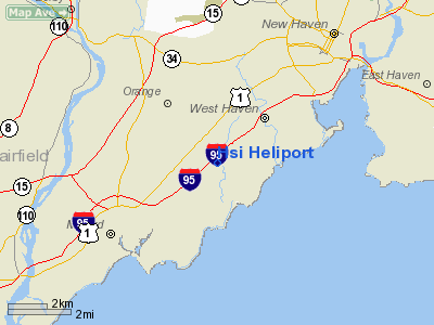
Helicopter Support Inc Heliport |
Location
& QuickFacts
|
FAA
Information Effective: |
2006-09-28 |
|
Airport
Identifier: |
5CT2 |
|
Longitude/Latitude: |
072-59-44.3730W/41-15-09.3490N
-72.995659/41.252597 (Estimated) |
|
Elevation: |
90 ft / 27.43 m (Estimated) |
|
Land: |
0 acres |
|
From
nearest city: |
3 nautical miles SE of Orange, CT |
|
Location: |
New Haven County, CT |
|
Magnetic Variation: |
14W (1990) |
Owner
& Manager
|
Ownership: |
Privately owned |
|
Owner: |
Helicopter Support Inc |
|
Address: |
89 Marsh Hill Rd
Orange, CT 06477 |
|
Phone
number: |
203-795-6051 |
|
Manager: |
David Adler, President |
|
Address: |
89 Marsh Hill Rd
Orange, CT 06477 |
|
Phone number: |
203-795-6051 |
Airport
Operations and Facilities
|
Airport
Use: |
Private |
|
Segmented
Circle: |
No |
|
Control
Tower: |
No |
|
Attendance
Schedule: |
UNATNDD |
|
Sectional
chart: |
New York |
|
Region: |
ANE - New England |
|
Boundary
ARTCC: |
ZBW - Boston |
|
Tie-in
FSS: |
BDR - Bridgeport |
|
FSS
on Airport: |
No |
|
FSS
Phone: |
866-293-5149 |
|
FSS
Toll Free: |
1-800-WX-BRIEF |
|
Runway Information
Helipad H1
|
Dimension: |
85 x 85 ft / 25.9 x 25.9 m |
|
Surface: |
ASPH, |
|
|
Runway H1 |
Runway |
|
Traffic
Pattern: |
Left |
Left |
|
Radio Navigation
Aids
|
ID |
Type |
Name |
Ch |
Freq |
Var |
Dist |
|
MMK |
NDB |
Meriden |
|
238.00 |
14W |
17.2 nm |
|
OP |
NDB |
Old Field Point Light |
|
316.00 |
13W |
17.5 nm |
|
TBY |
NDB |
Waterbury |
|
257.00 |
14W |
17.9 nm |
|
HF |
NDB |
Lomis |
|
244.00 |
15W |
28.4 nm |
|
BBN |
NDB |
Babylon |
|
275.00 |
14W |
39.1 nm |
|
PO |
NDB |
Meier |
|
403.00 |
12W |
47.8 nm |
|
FOK |
TACAN |
Suffolk Co |
047X |
|
13W |
29.9 nm |
|
HVN |
VOR/DME |
New Haven |
035X |
109.80 |
13W |
5.0 nm |
|
BDR |
VOR/DME |
Bridgeport |
25X |
108.80 |
12W |
8.0 nm |
|
MAD |
VOR/DME |
Madison |
041X |
110.40 |
13W |
14.2 nm |
|
CCC |
VOR/DME |
Calverton |
119X |
117.20 |
13W |
21.4 nm |
|
CMK |
VOR/DME |
Carmel |
113X |
116.60 |
12W |
26.5 nm |
|
HFD |
VOR/DME |
Hartford |
096X |
114.90 |
13W |
30.9 nm |
|
DPK |
VOR/DME |
Deer Park |
124X |
117.70 |
12W |
31.0 nm |
|
PWL |
VOR/DME |
Pawling |
090X |
114.30 |
12W |
41.3 nm |
|
GON |
VOR/DME |
Groton |
45Y |
110.85 |
14W |
42.9 nm |
|
IGN |
VOR/DME |
Kingston |
123X |
117.60 |
12W |
44.7 nm |
|
ORW |
VOR/DME |
Norwich |
037X |
110.00 |
14W |
48.5 nm |
|
LGA |
VOR/DME |
La Guardia |
078X |
113.10 |
12W |
48.6 nm |
|
HTO |
VORTAC |
Hampton |
083X |
113.60 |
13W |
36.7 nm |
|
BDL |
VORTAC |
Bradley |
027X |
109.00 |
14W |
43.6 nm |
|
BDR |
VOT |
Bridgeport |
|
109.25 |
|
8.0 nm |
|
ISP |
VOT |
Long Island Mac Arthur |
|
109.40 |
|
28.2 nm |
|
HFD |
VOT |
Hartford |
|
108.20 |
|
32.9 nm |
|
GON |
VOT |
Groton |
|
110.25 |
|
42.9 nm |
|
BDL |
VOT |
Bradley Intl |
|
111.40 |
|
43.6 nm |
Remarks
Hsi Heliport
Address:
New Haven County, CT
Tel:
203-795-6051
Images
and information placed above are from
http://www.airport-data.com/airport/5CT2/
We
thank them for the data!
| General
Info |
| Country |
United
States |
| State |
CONNECTICUT
|
| FAA ID |
5CT2
|
| Latitude |
41-15-09.349N
|
| Longitude |
072-59-44.373W
|
| Elevation |
90 feet
|
| Near City |
ORANGE
|
We don't guarantee the information is fresh and accurate. The data may
be wrong or outdated.
For more up-to-date information please refer to other sources.
|
|


