 |
|
|
|
|
|
Location
& QuickFacts
|
FAA
Information Effective: |
2006-09-28 |
|
Airport
Identifier: |
L22 |
|
Longitude/Latitude: |
116-24-28.0430W/34-07-40.0250N
-116.407790/34.127785 (Estimated) |
|
Elevation: |
3224 ft / 982.68 m (Surveyed) |
|
Land: |
35 acres |
|
From
nearest city: |
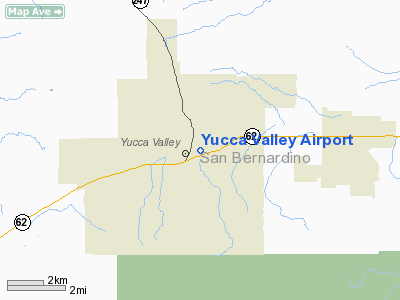
3 nautical miles E of Yucca Valley, CA |
|
Location: |
San Bernardino County, CA |
|
Magnetic Variation: |
14E (1985) |
Owner
& Manager
|
Ownership: |
Publicly owned |
|
Owner: |
Yucca Valley Airport Dist. |
|
Address: |
Box 2527
Yucca Valley, CA 92286 |
|
Phone
number: |
3 |
|
Manager: |
Rick Demel |
|
Address: |
41-800 Washington Street, B105, Box 440
Bermuda Dunes, CA 92201 |
|
Phone number: |
760-360-9665 |
Airport
Operations and Facilities
|
Airport
Use: |
Open to public |
|
Wind
indicator: |
Yes |
|
Segmented
Circle: |
Yes |
|
Control
Tower: |
No |
|
Attendance
Schedule: |
IREG |
|
Lighting
Schedule: |
RDO-CTL
ACTVT MIRL RY 06/24 - CTAF. |
|
Landing
fee charge: |
No |
|
Sectional
chart: |
Los Angeles |
|
Region: |
AWP - Western-Pacific |
|
Traffic
Pattern Alt: |
1000 ft |
|
Boundary
ARTCC: |
ZLA - Los Angeles |
|
Tie-in
FSS: |
RAL - Riverside |
|
FSS
on Airport: |
No |
|
FSS
Phone: |
951-351-3020 |
|
FSS
Toll Free: |
1-800-WX-BRIEF |
|
NOTAMs
Facility: |
RAL (NOTAM-d service avaliable) |
Airport
Communications
|
CTAF: |
123.000 |
|
Unicom: |
123.000
AUTOMATED UNICOM. |
Airport
Services
|
Airframe
Repair: |
MAJOR |
|
Power
Plant Repair: |
MINOR |
|
Bottled
Oxygen: |
NONE |
|
Bulk
Oxygen: |
NONE |
|
Runway Information
Runway 06/24
|
Dimension: |
4363 x 60 ft / 1329.8 x 18.3 m |
|
Surface: |
ASPH, Poor Condition
NUMEROUS CRACKS AND UNDULATIONS ON RY. |
|
Weight
Limit: |
Single wheel: 12500 lbs. |
|
Edge
Lights: |
Medium |
|
|
Runway 06 |
Runway 24 |
|
Traffic
Pattern: |
Right |
Left |
|
Markings: |
Basic, Good Condition |
Basic, Good Condition |
|
Displaced
threshold: |
360.00 ft |
330.00 ft |
|
Runway
End Identifier: |
No |
No |
|
Touchdown
Lights: |
No |
No |
|
Obstruction: |
40 ft pole, 1030.0 ft from runway, 40 ft left
of centerline, 20:1 slope to clear
RWY 06 APCH RATIO TO DSPLCD THLD 20:1.
+6 FT FENCE 0-75 FT FM EOR 60 FT L AND +2 FT FENCE 75 FT FM
EOR 60-125 FT R; +5 FT SIGN 82 FT FM RY END 100 FT R; +11
FT ROAD 190 FT FM RY END 125 FT R TO 90 FT FM RY END 125 FT
L. |
25 ft trees, 940.0 ft from runway, 100 ft left
of centerline, 29:1 slope to clear
APCH RATIO 50:1 TO DSPLCD THR.
+6 FT OBSTRUCTION LIGHTED FENCE 10 FT FM EOR 45 FT L TO 125
FT R. |
|
Radio Navigation
Aids
|
ID |
Type |
Name |
Ch |
Freq |
Var |
Dist |
|
SJY |
NDB |
San Jacinto |
|
227.00 |
14E |
35.6 nm |
|
SB |
NDB |
Petis |
|
397.00 |
14E |
47.9 nm |
|
NXP |
TACAN |
Coyote |
063X |
|
14E |
16.1 nm |
|
RIV |
TACAN |
March |
077X |
|
14E |
45.2 nm |
|
HDF |
VOR |
Homeland |
|
113.40 |
14E |
44.1 nm |
|
PSP |
VORTAC |
Palm Springs |
102X |
115.50 |
13E |
15.5 nm |
|
TNP |
VORTAC |
Twentynine Palms |
089X |
114.20 |
15E |
31.8 nm |
|
TRM |
VORTAC |
Thermal |
109X |
116.20 |
13E |
32.5 nm |
|
HEC |
VORTAC |
Hector |
074X |
112.70 |
15E |
40.3 nm |
Remarks
-
PAEW ADJACENT RY 06/24.
-
ESTABD PRIOR TO 5/15/59.
Based Aircraft
|
Aircraft
based on field: |
50 |
|
Single
Engine Airplanes: |
42 |
|
Multi
Engine Airplanes: |
4 |
|
Helicopters: |
1 |
|
Ultralights: |
3 |
Operational Statistics
|
Aircraft
Operations: |
279/Week |
|
General
Aviation Local: |
34.5% |
|
General
Aviation Itinerant: |
65.5% |
Yucca Valley Airport
Address:
San Bernardino County, CA
Tel:
760-360-9665
Images
and information placed above are from
http://www.airport-data.com/airport/L22/
We
thank them for the data!
| General
Info |
| Country |
United
States |
| State |
CALIFORNIA
|
| FAA ID |
L22
|
| Latitude |
34-07-40.025N
|
| Longitude |
116-24-28.043W
|
| Elevation |
3224 feet
|
| Near City |
YUCCA
VALLEY |
We don't guarantee the information is fresh and accurate. The data may
be wrong or outdated.
For more up-to-date information please refer to other sources.
|
|


