|
|
| Whiteman Airport |
 |
| IATA: WHP – ICAO: KWHP |
| Summary |
| Airport type |
Public |
| Operator |
Los Angeles County |
| Location |
Los Angeles, California |
| Elevation AMSL |
1,003 ft / 305.7 m |
| Coordinates |
34°15′33.57″N 118°24′48.35″W / 34.259325°N 118.4134306°W / 34.259325; -118.4134306Coordinates: 34°15′33.57″N 118°24′48.35″W / 34.259325°N 118.4134306°W / 34.259325; -118.4134306 |
| Runways |
| Direction |
Length |
Surface |
| ft |
m |
| 12/30 |
4,120 |
1,256 |
Asphalt |
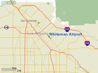
Whiteman Airport (IATA: WHP, ICAO: KWHP) is a general aviation airport located in the Pacoima district of Los Angeles, California, United States.
Located in the San Fernando Valley, Hollywood celebrities sometimes use this airport; however, Van Nuys Airport is used more often.
Whiteman Airport is home to Squadron 35 of the Civil Air Patrol. Facilities
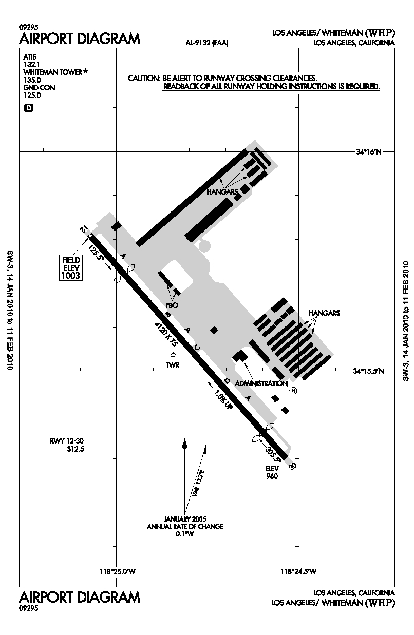
Whiteman Airport covers 184 acres (74 ha) and has one runway:
- Runway 12/30: 4,120 x 75 ft (1,256 x 23 m), Surface: Asphalt
Barton Heliport of the LACoFD
- The Los Angeles County Fire Department Air Operations unit is based at Barton Heliport, a heliport in the southeast corner of this airport.
The above content comes from Wikipedia and is published under free licenses – click here to read more.
Location
& QuickFacts
|
FAA
Information Effective: |
2006-09-28 |
|
Airport
Identifier: |
WHP |
|
Longitude/Latitude: |
118-24-48.3590W/34-15-33.5710N
-118.413433/34.259325 (Estimated) |
|
Elevation: |
1003 ft / 305.71 m (Estimated) |
|
Land: |
184 acres |
|
From
nearest city: |
1 nautical miles E of Los Angeles, CA |
|
Location: |
Los Angeles County, CA |
|
Magnetic Variation: |
14E (1990) |
Owner
& Manager
|
Ownership: |
Publicly owned |
|
Owner: |
Los Angeles Co |
|
Address: |
P.o. Box 1460
Alhambra, CA 91802-1460 |
|
Phone number: |
626-300-4615 |
|
Manager: |
Scott Wardle |
|
Address: |
12653 Osborne St.
Pacoima, CA 91331 |
|
Phone number: |
310-752-0574 |
Airport
Operations and Facilities
|
Airport
Use: |
Open to public |
|
Wind
indicator: |
Yes |
|
Segmented
Circle: |
Yes |
|
Control
Tower: |
Yes |
|
Attendance
Schedule: |
ALL/ALL/ALL |
|
Lighting
Schedule: |
DUSK-DAWN |
|
Beacon
Color: |
Clear-Green (lighted land airport) |
|
Sectional
chart: |
Los Angeles |
|
Region: |
AWP - Western-Pacific |
|
Traffic
Pattern Alt: |
1000 ft |
|
Boundary
ARTCC: |
ZLA - Los Angeles |
|
Tie-in
FSS: |
HHR - Hawthorne |
|
FSS
on Airport: |
No |
|
FSS
Phone: |
310-970-0102 |
|
FSS
Toll Free: |
1-800-WX-BRIEF |
|
NOTAMs
Facility: |
WHP (NOTAM-d service avaliable) |
|
Federal Agreements: |
NGY |
Airport
Communications
|
CTAF: |
135.000 |
|
Unicom: |
122.950 |
Airport
Services
|
Fuel
available: |
100LLA |
|
Airframe
Repair: |
MAJOR |
|
Power
Plant Repair: |
MAJOR |
|
Bottled
Oxygen: |
HIGH |
|
Bulk
Oxygen: |
HIGH |
|
Runway Information
Runway 12/30
|
Dimension: |
4120 x 75 ft / 1255.8 x 22.9 m |
|
Surface: |
ASPH, Good Condition |
|
Weight
Limit: |
Single wheel: 12500 lbs. |
|
Edge
Lights: |
Medium |
|
|
Runway 12 |
Runway 30 |
|
Longitude: |
118-25-04.5300W |
118-24-32.1500W |
|
Latitude: |
34-15-48.7000N |
34-15-18.0600N |
|
Elevation: |
1003.00 ft |
960.00 ft |
|
Alignment: |
127 |
127 |
|
Traffic
Pattern: |
Left |
Right |
|
Markings: |
Basic, Good Condition |
Basic, Good Condition |
|
Crossing
Height: |
40.00 ft |
40.00 ft |
|
Displaced
threshold: |
729.00 ft |
478.00 ft |
|
VASI: |
2-light PAPI on right side |
2-light PAPI on left side |
|
Visual
Glide Angle: |
3.30� |
3.30� |
|
Runway
End Identifier: |
Yes |
Yes |
|
Centerline
Lights: |
No |
No |
|
Touchdown
Lights: |
No |
No |
|
Obstruction: |
30 ft pline, 200.0 ft from runway, 45 ft right
of centerline
APCH RATIO 30:1 TO DSPLCD THLD; APCH RATIO TO DSPLCD THLD
OVER 33 FT BLDG 850 FT FM DSPLCD THLD 95 FT R 25:1.
HAS + 6 FT FENCE 60 FT FM EOR AND ROAD 70 FT FM EOR 125 FT
L TO R; +12 FT BLDG 135-200 FM FM EOR 20-50 FT L; +24 FT LIGHT
STANDARD 140 FT FM EOR 45 FT R. |
30 ft pline, 200.0 ft from runway, 10 ft right
of centerline
APCH RATIO 22:1 TO DSPLCD THLD; APCH RATIO TO DSPLCD THLD
OVER +35 FT TREE 488 FT FM DSPLCD THLD 110 FT R 13:1.
HAS 35 FT TREES 50 FT FM EOR 110 FT R; +6 FT FENCE 30 FT FM
EOR 125 FT L TO R; ROAD 80 FT FM EOR 125 FT L TO R; +30 FT
PLINES 160 FT FM EOR 125 FT L TO R; + 20 FT LIGHT 75 FT FM
EOR 20 FT L. |
|
Decleard
distances: |
Take off run available 3442.00 ft
Take off distance available 4120.00 ft
Actual stop distance available 3190.00 ft
Landing distance available 3181.00 ft |
Take off run available 3191.00 ft
Take off distance available 4120.00 ft
Actual stop distance available 3940.00 ft
Landing distance available 3462.00 ft |
|
Radio Navigation
Aids
|
ID |
Type |
Name |
Ch |
Freq |
Var |
Dist |
|
EMT |
NDB |
El Monte |
|
359.00 |
15E |
21.6 nm |
|
CPM |
NDB |
Compton |
|
378.00 |
15E |
23.8 nm |
|
GWF |
NDB |
Gen William J Fox |
|
282.00 |
15E |
30.4 nm |
|
NTD |
TACAN |
Point Mugu |
043X |
|
15E |
36.2 nm |
|
VNY |
VOR/DME |
Van Nuys |
078X |
113.10 |
15E |
4.4 nm |
|
SMO |
VOR/DME |
Santa Monica |
045X |
110.80 |
15E |
15.1 nm |
|
VTU |
VOR/DME |
Ventura |
019X |
108.20 |
15E |
32.8 nm |
|
CMA |
VOR/DME |
Camarillo |
105X |
115.80 |
15E |
34.0 nm |
|
ELB |
VOR/DME |
El Toro |
119X |
117.20 |
14E |
48.8 nm |
|
LAX |
VORTAC |
Los Angeles |
083X |
113.60 |
15E |
19.6 nm |
|
FIM |
VORTAC |
Fillmore |
072X |
112.50 |
15E |
24.0 nm |
|
LHS |
VORTAC |
Lake Hughes |
021X |
108.40 |
15E |
26.7 nm |
|
PMD |
VORTAC |
Palmdale |
092X |
114.50 |
15E |
28.3 nm |
|
POM |
VORTAC |
Pomona |
041X |
110.40 |
15E |
33.0 nm |
|
SLI |
VORTAC |
Seal Beach |
104X |
115.70 |
15E |
33.7 nm |
|
GMN |
VORTAC |
Gorman |
108X |
116.10 |
16E |
39.5 nm |
|
PDZ |
VORTAC |
Paradise |
059X |
112.20 |
15E |
48.5 nm |
|
LAX |
VOT |
San Pedro Hill |
|
113.90 |
|
31.1 nm |
|
SNA |
VOT |
Santa Ana |
|
110.00 |
|
44.3 nm |
Remarks
-
HELICOPTER OPNS 2500'
MSL (1500' AGL) AND BELOW.
-
POWER LINES SW OF RY
PENETRATE 7:1 TRANSITIONAL SFC.
-
BIRDS ON AND INVOF ARPT.
-
AIRPORT CLOSED TO HELICOPTER
TRAINING / PATTERN OPERATIONS 2000-0800.
Based Aircraft
|
Aircraft
based on field: |
722 |
|
Single
Engine Airplanes: |
655 |
|
Multi
Engine Airplanes: |
42 |
|
Jet Engine
Airplanes: |
15 |
|
Helicopters: |
10 |
Operational Statistics
|
Aircraft
Operations: |
297/Day |
|
Air Taxi: |
0.0% |
|
General
Aviation Local: |
47.0% |
|
General
Aviation Itinerant: |
52.9% |
|
Military: |
0.1% |
Whiteman Airport
Address:
Los Angeles County, CA
Tel:
626-300-4615, 310-752-0574
Images
and information placed above are from
http://www.airport-data.com/airport/WHP/
We
thank them for the data!
| General
Info |
| Country |
United
States |
| State |
CALIFORNIA
|
| FAA ID |
WHP
|
| Latitude |
34-15-33.571N
|
| Longitude |
118-24-48.359W
|
| Elevation |
1003 feet
|
| Near City |
LOS ANGELES
|
We don't guarantee the information is fresh and accurate. The data may
be wrong or outdated.
For more up-to-date information please refer to other sources.
|
|