 |
|
|
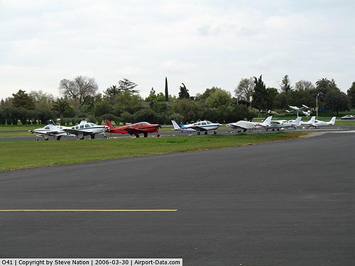 |
(Click on the photo to enlarge) |
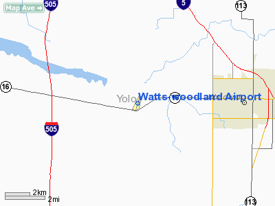
Location
& QuickFacts
|
FAA
Information Effective: |
2006-09-28 |
|
Airport
Identifier: |
O41 |
|
Longitude/Latitude: |
121-52-19.4780W/38-40-25.9550N
-121.872077/38.673876 (Estimated) |
|
Elevation: |
125 ft / 38.10 m (Surveyed) |
|
Land: |
100 acres |
|
From
nearest city: |
4 nautical miles W of Woodland, CA |
|
Location: |
Yolo County, CA |
|
Magnetic Variation: |
16E (1985) |
Owner
& Manager
|
Ownership: |
Privately owned |
|
Owner: |
M B Watts |
|
Address: |
17992 Co Rd 94b
Woodland, CA 95776 |
|
Phone
number: |
530-662-9631 |
|
Manager: |
M B Watts |
|
Address: |
17992 Co Rd 94b
Woodland, CA 95776 |
|
Phone number: |
530-662-9631 |
Airport
Operations and Facilities
|
Airport
Use: |
Open to public |
|
Wind
indicator: |
Yes |
|
Segmented
Circle: |
No |
|
Control
Tower: |
No |
|
Attendance
Schedule: |
OCT-APR/ALL/0800-1700,MAY-SEP/ALL/0700-1800 |
|
Lighting
Schedule: |
DUSK-DAWN
ACTVT MIRL RY 18/36 - CTAF. |
|
Beacon
Color: |
Clear-Green (lighted land airport) |
|
Landing
fee charge: |
No |
|
Sectional
chart: |
San Francisco |
|
Region: |
AWP - Western-Pacific |
|
Boundary
ARTCC: |
ZOA - Oakland |
|
Tie-in
FSS: |
RIU - Rancho Murieta |
|
FSS
on Airport: |
No |
|
FSS
Phone: |
916-354-0161 |
|
FSS
Toll Free: |
1-800-WX-BRIEF |
|
NOTAMs
Facility: |
RIU (NOTAM-d service avaliable) |
|
Federal Agreements: |
N |
Airport
Communications
|
CTAF: |
122.800 |
|
Unicom: |
122.800 |
Airport
Services
|
Fuel
available: |
100LLA
FUEL 24 HRS WITH CREDIT CARD. |
|
Airframe
Repair: |
MAJOR |
|
Power
Plant Repair: |
MAJOR |
|
Bottled
Oxygen: |
HIGH |
|
Bulk
Oxygen: |
HIGH |
|
Runway Information
Runway 18/36
|
Dimension: |
3770 x 60 ft / 1149.1 x 18.3 m |
|
Surface: |
ASPH, Good Condition |
|
Weight
Limit: |
Single wheel: 12000 lbs.
GROSS PAVEMENT STRENGTH PRVDD BY MGR; 12000 LBS. |
|
Edge
Lights: |
Medium |
|
|
Runway 18 |
Runway 36 |
|
Longitude: |
121-52-11.7200W |
121-52-27.3160W |
|
Latitude: |
38-40-43.4800N |
38-40-08.3980N |
|
Elevation: |
107.00 ft |
124.00 ft |
|
Alignment: |
127 |
19 |
|
Traffic
Pattern: |
Left |
Left |
|
Markings: |
Basic, Fair Condition |
Basic, Fair Condition |
|
Displaced
threshold: |
630.00 ft |
385.00 ft |
|
VASI: |
tri-color on left side |
|
|
Runway
End Identifier: |
No |
No |
|
Centerline
Lights: |
No |
No |
|
Touchdown
Lights: |
No |
No |
|
Obstruction: |
40 ft trees, 400.0 ft from runway, 5:1 slope
to clear
APCH RATIO 13:1 TO DSPLCD THLD.
+15 FT ROAD 125 FT FM EOR AND +20 FT BUSHES 100 FT RIGHT 75
FT FM EOR. |
20 ft ant, 300.0 ft from runway, 100 ft right
of centerline, 5:1 slope to clear
APCH RATIO 34:1 TO DSPLCD THLD.
+4'
FENCE 55' & ROAD 80' FROM THR. |
|
Radio Navigation
Aids
|
ID |
Type |
Name |
Ch |
Freq |
Var |
Dist |
|
MY |
NDB |
Halow |
|
222.00 |
16E |
32.2 nm |
|
SUU |
TACAN |
Travis |
113X |
|
17E |
26.0 nm |
|
BAB |
TACAN |
Beale |
023X |
|
16E |
34.3 nm |
|
TZZ |
VOR |
Travis |
|
116.40 |
17E |
20.0 nm |
|
MCC |
VOR/DME |
Mc Clellan |
029X |
109.20 |
17E |
22.0 nm |
|
MYV |
VOR/DME |
Marysville |
045X |
110.80 |
16E |
29.1 nm |
|
CCR |
VOR/DME |
Concord |
117X |
117.00 |
17E |
38.7 nm |
|
STS |
VOR/DME |
Santa Rosa |
077X |
113.00 |
16E |
45.2 nm |
|
SAC |
VORTAC |
Sacramento |
099X |
115.20 |
17E |
20.5 nm |
|
ILA |
VORTAC |
Williams |
091X |
114.40 |
18E |
25.0 nm |
|
SGD |
VORTAC |
Scaggs Island |
058X |
112.10 |
17E |
38.0 nm |
|
MXW |
VORTAC |
Maxwell |
037X |
110.00 |
18E |
42.0 nm |
|
SMF |
VOT |
Sacramento Metropolitan |
|
111.40 |
|
13.2 nm |
|
SAC |
VOT |
Sacramento Executive |
|
111.40 |
|
20.0 nm |
Remarks
-
ULTRALIGHT OPERATIONS
PROHIBITED.
-
TWIN ENGINE
ACFT BACK TAXI ON RY.
-
RY 18 UNLGTD
TREES HIGHER THAN OBSTN LGTS.
-
ESTABD PRIOR TO 15 MAY
1959.
Based Aircraft
|
Aircraft
based on field: |
67 |
|
Single
Engine Airplanes: |
54 |
|
Multi
Engine Airplanes: |
13 |
Operational Statistics
|
Aircraft
Operations: |
83/Day |
|
Air Taxi: |
13.3% |
|
General
Aviation Local: |
43.3% |
|
General
Aviation Itinerant: |
43.3% |
Watts-woodland Airport
Address:
Yolo County, CA
Tel:
530-662-963
Images
and information placed above are from
http://www.airport-data.com/airport/O41/
We
thank them for the data!
| General
Info |
| Country |
United
States |
| State |
CALIFORNIA
|
| FAA ID |
O41
|
| Latitude |
38-40-25.955N
|
| Longitude |
121-52-19.478W
|
| Elevation |
125 feet
|
| Near City |
WOODLAND
|
We don't guarantee the information is fresh and accurate. The data may
be wrong or outdated.
For more up-to-date information please refer to other sources.
|
|


