 |
|
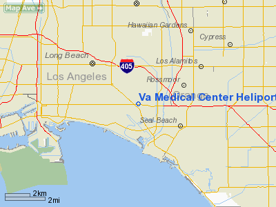
Veterans Administration Medical Center Heliport |
Location
& QuickFacts
|
FAA
Information Effective: |
2006-09-28 |
|
Airport
Identifier: |
CL48 |
|
Longitude/Latitude: |
118-07-10.2350W/33-46-33.0610N
-118.119510/33.775850 (Estimated) |
|
Elevation: |
76 ft / 23.16 m (Estimated) |
|
Land: |
0 acres |
|
From
nearest city: |
0 nautical miles E of Long Beach, CA |
|
Location: |
Los Angeles County, CA |
|
Magnetic Variation: |
14E (1985) |
Owner
& Manager
|
Ownership: |
Publicly owned |
|
Owner: |
Veterans Administration |
|
Address: |
5901 E. 7th Street
Long Beach, CA 90822 |
|
Phone
number: |
310-494-5400 |
|
Manager: |
Jule D. Moravec |
|
Address: |
5901 E. 7th Street
Long Beach, CA 90822 |
|
Phone number: |
310-494-5400 |
Airport
Operations and Facilities
|
Airport
Use: |
Private
MEDICAL. |
|
Segmented
Circle: |
No |
|
Control
Tower: |
No |
|
Attendance
Schedule: |
UNATNDD |
|
Sectional
chart: |
Los Angeles |
|
Region: |
AWP - Western-Pacific |
|
Boundary
ARTCC: |
ZLA - Los Angeles |
|
Tie-in
FSS: |
HHR - Hawthorne |
|
FSS
on Airport: |
No |
|
FSS
Phone: |
310-970-0102 |
|
FSS
Toll Free: |
1-800-WX-BRIEF |
|
Runway Information
Helipad H1
|
Dimension: |
220 x 80 ft / 67.1 x 24.4 m |
|
Surface: |
CONC, |
|
|
Runway H1 |
Runway |
|
Traffic
Pattern: |
Left |
Left |
|
Radio Navigation
Aids
|
ID |
Type |
Name |
Ch |
Freq |
Var |
Dist |
|
CPM |
NDB |
Compton |
|
378.00 |
15E |
9.3 nm |
|
EMT |
NDB |
El Monte |
|
359.00 |
15E |
19.3 nm |
|
PAI |
NDB |
Pacoima |
|
370.00 |
15E |
32.6 nm |
|
SB |
NDB |
Petis |
|
397.00 |
14E |
41.2 nm |
|
RIV |
TACAN |
March |
077X |
|
14E |
42.9 nm |
|
NFG |
TACAN |
Camp Pendleton |
055X |
|
13E |
47.5 nm |
|
RAL |
VOR |
Riverside |
|
112.40 |
15E |
35.1 nm |
|
HDF |
VOR |
Homeland |
|
113.40 |
14E |
46.7 nm |
|
ELB |
VOR/DME |
El Toro |
119X |
117.20 |
14E |
20.3 nm |
|
SMO |
VOR/DME |
Santa Monica |
045X |
110.80 |
15E |
21.9 nm |
|
VNY |
VOR/DME |
Van Nuys |
078X |
113.10 |
15E |
32.7 nm |
|
SLI |
VORTAC |
Seal Beach |
104X |
115.70 |
15E |
3.3 nm |
|
LAX |
VORTAC |
Los Angeles |
083X |
113.60 |
15E |
18.2 nm |
|
POM |
VORTAC |
Pomona |
041X |
110.40 |
15E |
24.6 nm |
|
SXC |
VORTAC |
Santa Catalina |
051X |
111.40 |
15E |
28.4 nm |
|
PDZ |
VORTAC |
Paradise |
059X |
112.20 |
15E |
30.7 nm |
|
OCN |
VORTAC |
Oceanside |
100X |
115.30 |
15E |
47.7 nm |
|
LAX |
VOT |
San Pedro Hill |
|
113.90 |
|
11.0 nm |
|
SNA |
VOT |
Santa Ana |
|
110.00 |
|
13.8 nm |
Remarks
-
VFR, PRIVATE
USE ONLY; 2-WAY RADIO COMMUNICATIONS WITH LONG BEACH ATCT.
Va Medical Center Heliport
Address:
Los Angeles County, CA
Tel:
310-494-5400
Images
and information placed above are from
http://www.airport-data.com/airport/CL48/
We
thank them for the data!
| General
Info |
| Country |
United
States |
| State |
CALIFORNIA
|
| FAA ID |
CL48
|
| Latitude |
33-46-33.061N
|
| Longitude |
118-07-10.235W
|
| Elevation |
76 feet
|
| Near City |
LONG BEACH
|
We don't guarantee the information is fresh and accurate. The data may
be wrong or outdated.
For more up-to-date information please refer to other sources.
|
|


